Fun waves to end the week, bigger surf Monday/Tuesday

Java, Bali, Lombok, Sumbawa forecast by Craig Brokensha (issued Tue 7th Oct)
Best Days: Wednesday, Thursday, Friday and Saturday mornings at exposed spots, later Sunday, Monday and Tuesday
This week and weekend (Oct 8 - 12)
A kick in S/SW swell was seen yesterday providing a bit more size across the region, but this has backed off a touch into today with favourable winds.
We should see a new medium-range S/SW groundswell filling in tomorrow and reaching just over the 6ft range at exposed spots through the afternoon before dipping away slowly through Thursday and further into the end of the week.
Winds will become a little funky into Friday and Saturday as E/SE trades back off and more variable breezes with a touch of west in them develop across the region. This should favour exposed breaks through the mornings as the swell bottoms out to an inconsistent 3-4ft+.
Sunday will start out slow but a new long-range and very inconsistent SW groundswell should arrive later in the day ahead of a much more solid kick of S/SW swell into Monday and Tuesday, discussed in more detail below.
 Next week onwards (Oct 13 onwards)
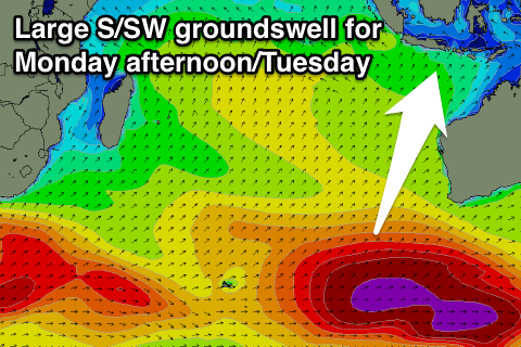
As touched on the last few updates a large S/SW groundswell due into the start of the week starting the 13th is shaping up nicely.
Already a vigorous polar storm firing up south-east of South Africa has set in motion a strong long-period SW groundswell, but by the time it arrives across our coast there isn't expected to be any major size. This is the swell responsible for Sunday afternoon's kick in size, with exposed spots likely to reach the very inconsistent 4-6ft at exposed spots later in the day.
Into Monday though, a more consistent and larger S/SW swell should fill in, generated by a broad fetch of severe-gale W/SW winds firing up on top of an active sea state from pre-frontal W/NW gales just ahead of it.
This should produce a large S/SW groundswell for Monday afternoon, reaching 8-10ft at exposed spots in Bali before easing from a similar size Tuesday morning.
Winds at this stage look good with variable breezes during the morning at selected locations before moderate to fresh E/SE trades kick in.
From here on there's nothing too major on the cards, but we'll review this Thursday.
16 day Bali Forecast Graph
16 day East Java Forecast Graph
16 day Sumbawa Forecast Graph
Comments
Hey craig wheres the lwt currently please advise me
Hi Camel,
Relative to Australia it's just west of WA, with another amplification just east of New Zealand, a third just west of South America and a last node (peak) to the west of South Africa.
Thank you craig . Ive been hoping for this storm to do sumthing for us this wknd ( in oz )
Hey Craig, any update on the mid-sized pulse reaching Bali late next week? I need to sort out whether to take just a standard shorty or bring a step-up as well.
Hi Wes, sorry didn't get a chance for an update yesterday.
Yep Monday/Tuesday's large pulse of S/SW groundswell is still on track and even looking a little stronger.
Probably looking at 8-10ft+ at exposed spots later Monday in Bali, easing from 8-10ft Tuesday and further through the week (moderate pulse Friday).
Winds looking good with variable breezes each morning and fresh E/SE-SE trades into the afternoons.
Hey craig with the lwt near w.a. I hope the storm track flares up but its not . This is new to me , can u explain why the storms arent moving into the window
Hi Camel, it was only west of WA for a short period before moving west and across Australia and is now pushing through the Bight.
This is what's bringing the strong storm activity focussed towards south-eastern Australia.
You want the LWT to either become real strong/amplified to the west of WA and or stall there to get large swells.
Ok it was there 8th oct but now its moved east ?
Yeah, that's it, the best way to track it before we get it up and running is here:
http://www.weatherzone.com.au/models/?lt=hemisphere&lc=sh
24hour steps of where the LWT nodes (peaks) are.
Unfortunately that link is home page for me thanks craig
G'day Craig - Anything on the horizon for the long term from around the 24th?
Cheers!
Not looking good at this stage EWOK, big blocking systems in the Indian Ocean and no major swells at all.
Cheers...i think haha, hopefully something rideable anyway