Bali: Nothing major until Friday, better next week

Java, Bali, Lombok, Sumbawa forecast by Craig Brokensha (issued Tue 1st Jul)
Best Days: Tomorrow, Friday onwards
This week and weekend (Jul 1 - 6)
After late last week's large and powerful SW groundswell event, wave heights have slowly backed away over the weekend, bottoming out as expected his morning across the region.
A long-range and inconsistent increase in SW groundswell is due through this afternoon and this should top exposed spots back up to an inconsistent 4-5ft+, holding into tomorrow morning before easing slightly through the afternoon and further Thursday.
Fresh E/SE trades are expected to strengthen into this evening and persist at strengthen through most of the forecast period, favouring protected spots which will be smaller than exposed breaks.
Friday's large kick in SW groundswell is still on track, with the storm generating the swell coming in a touch stronger than initially forecast on Thursday resulting in a slight upgrade in the size as well as an earlier arrival.
The swell should arrive overnight Thursday and build through Friday, likely reaching an inconsistent 6-8ft+ across exposed breaks during the afternoon.
A steady drop in size is then due into Saturday from 6ft to occasionally 8ft and further down through Sunday.
Next Monday onwards (Jul 7 onwards)
 Next week is looking great with a couple of large groundswells on the cards, the first from the SW Monday ahead of a possible follow up S/SW groundswell Friday.
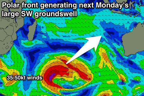
This will be linked to a strong amplification of the Long Wave Trough moving slowly from the Central Indian Ocean towards WA over the coming days before pushing east and across Australia early next week. This will strengthen and intensify polar fronts pushing up through the Indian Ocean as they feed off the upper atmospheric steering.
Currently an initial polar front is falling under the influence of the LWT, strengthening south-east of Madagascar ahead of an east-northeast projection through tomorrow and then north-east projection towards Bali Thursday.
This should generate a large and fairly consistent SW groundswell that is expected to fill in Monday and peak through the middle of the day/afternoon to 8ft+ across exposed breaks.
A slow drop in size is due through the middle of the week, softened by a couple of weaker secondary fronts firing up towards us in the wake of the initial swell generating front.
The trades should also start to back off a bit but remain moderate to fresh in strength.
The S/SW groundswell for later next week will be produced as the Long Wave Trough moves right over WA, directing polar fronts through our southern swell window, up off the WA coast. At this stage the models are still moving around regarding the strength and positioning of the fronts pushing towards WA, but we'll provide another update on Thursday.
16 day Bali Forecast Graph
16 day East Java Forecast Graph
16 day Sumbawa Forecast Graph