Overactive period ahead for Indonesia

Java, Bali, Lombok, Sumbawa forecast by Craig Brokensha (issued Tue 17th Jun)
Best Days: Thursday onwards
This week (Jun 17 - 20)
Thursday afternoon's and Friday morning's kick in strong S/SW groundswell failed to really show around Bali, which is a weird one as the same swell hit WA a few days before and offered large waves across most of the state. Instead medium levels of swell persisted, and we've seen a low point in swell activity the last two days.
A long-range and inconsistent pulse of SW groundswell is due tomorrow across the region but this will be overshadowed by a much larger and stronger SW groundswell Thursday and Friday.
The source of these swells was a long-lived frontal progression that started it's life south of South Africa around Wednesday/Thursday last week and pushed through the Southern Indian Ocean while aiming bursts of severe-gale W/SW winds through our swell window.
The progression is currently weakening west of WA, with a final mid-latitude front pushing favourably north up towards us through yesterday and this morning, helping to add to the consistency of the large swell.
Size wise, tomorrow's precursor should come in at an inconsistent 4-5ft+ at exposed locations around Bali, but Thursday should see wave heights climbing considerably into the afternoon as the large SW groundswell fills in. By close of play exposed locations should be in the 10ft+ range ahead of a a peak overnight and then drop from a similar size Friday morning.
Moderate to fresh E/SE trades will favour slightly protected breaks but expect less size the more you tuck away from the swell.
This weekend onwards (Jun 21 onwards)
The large swell seen through the week should continue to tail off into Saturday, from 6ft to occasionally 8ft at exposed spots but from Sunday onwards we should see a series of large SW groundswell pulses filling in.
This will be related to the westerly storm track through the Southern Indian Ocean remaining over-active through the coming week with a couple of strong nodes of the Long Wave Trough traversing the basin.
With this a series of vigorous polar fronts will fire up towards us, the first through the coming days, generating a large pulse that should arrive very late Monday and peak Tuesday to 6-8ft at exposed breaks with the possibly bigger bomb in the mix.
The swell should back off a touch into Wednesday back to 6ft+ or so at exposed locations as closer-range levels of S/SW swell fill in from a mid-latitude low forming off WA Sunday evening.
A low point in swell is likely on Thursday but only short-lived with another large but long-range and less consistent swell fills in for Friday.
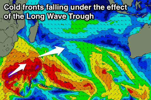 This swell will be generated by a much stronger and broader frontal progression (right) firing up under South Africa, under the effects of the Long Wave Trough (shown below in the video as the red/purple stream lines pushing under South Africa), generating large pumping swell for J-Bay but also a very strong long-period SW groundswell for us later next week.
At this stage we're looking at another swell in the 10ft range but we'll review this again on Thursday.
Coming back to the winds expected from the weekend onwards and we should see light and variable breezes developing with weak E/SE trades from mid next week onwards.
16 day Bali Forecast Graph
16 day East Java Forecast Graph
16 day Sumbawa Forecast Graph
Comments
That's a great map/video of the swell.
The video is actually of the 500hPa winds in the upper atmosphere, and indicate the position and strength of the Long Wave Trough.
These winds steer the surface systems and that's why you can see the fronts on our WAMs wind charts following a similar path to the upper level pattern.
Outside corner is starting to break with that new swell filling in. Shot by AB: