Bali: Easing surf over coming days, large pulse due late next week

Java, Bali, Lombok, Sumbawa forecast by Craig Brokensha (issued Thu 12th Jun)
Best Days: Friday, Satureday, Sunday, Tuesday onwards
Tomorrow and this weekend (Jun 13 - 15)
A strong but inconsistent long-period S/SW groundswell should be filling in across Indonesia today with a peak due to later this afternoon to 6-8ft at exposed spots around Bali.
Into tomorrow and the weekend the swell should drop away slowly, with a reinforcing but only medium sized S/SW groundswell on Saturday likely to soften the blow. Exposed spots should still offer 4-5ft+ waves most of Saturday before backing off noticeably later and back to 3ft or so Sunday. Some small SE trade-swell may be seen at exposed breaks as well from Saturday through Tuesday next week from a strong easterly ridge to the south of the region, but the size likely won't be above the background S/SW groundswell.
E/SE trades will kick up a bit tomorrow and remain fresh through Saturday but from Sunday afternoon onwards and more so Monday we should see them becoming lighter, and even variable each morning.
Next Monday onwards (Jun 16 onwards)
As touched on last update, besides a couple of medium sized background SW groundswells for Tuesday and more so Wednesday there's nothing major on the cards until Thursday and Friday, but this will be in the form of an large and powerful SW groundswell.
This will be related to a vigorous and long-lived polar front progression taking place over the coming days, initiated under South Africa and ending south-west of Western Australia.
An initial tight polar low currently south-east of Madagascar will set in motion an active sea state for a secondary much larger and broader polar front to push up and over. A pro-longed fetch of gale to severe-gale W/SW winds will be generated through our south-west swell window before the progression finally starts to break down while approaching WA on Monday.
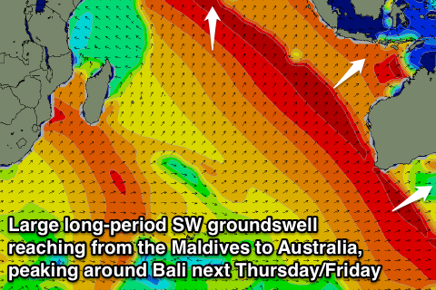 What will result is a large and powerful SW groundswell that will impact the Maldives, Sumatra, Bali and Australia, with the swell expected to arrive strongly Thursday afternoon and likely peak overnight but hold well into Friday morning.
Size wise we should see 8-10ft+ waves either side of the peak at exposed spots around Bali, with a touch less size towards Sumbawa.
Winds are this stage look to be generally variable, but we'll confirm this in Tuesday's update.
Longer term we may see another similar but slightly smaller SW groundswell 3-4 days layer, but we'll have another look at this on Tuesday.
16 day Bali Forecast Graph
16 day East Java Forecast Graph
16 day Sumbawa Forecast Graph
Comments
Surf update Thursday 12th June. Uluwatu was only 5ft today and maybe 3-4ft
on dusk and getting smaller.The surf was good but size wise a bit disappointing.
FRIDAY 13th update ulus swell 2-3t early then rapid rise 6ft plus maybe dont figure bigger than Thursday anyway only downside a bit windy.
Evo, had similar reports from a friend over there, weird this swell hasn't hit at all, must be missing Bali somehow, as it came in very strong across WA, 8ft+ Margs, 6ft sets up Gero way.
Craig, same Nurda in West Java reporting waves bigger yesterday than today......waves gone twilight zone
Peak was expected later yesterday, but nothing really showed.
Craig/Ben
What sort of confidence levels do you have in the back end of this 16 day forecast? when l say back end l'm thinking 25th on. Decision time!
Thanks
At this early stage I'd put 50% chance as the models are stuggling to decide what form a vigorous polar front will take while pushing up past the WA coast Friday next week. One solution has it turning into a cut-off low which isn't as good for swell production.
I'd keep a close eye on each update over the coming days. By next Tuesday we should be starting to firm up though.
Thanks heap Craig!
Really appreciate you taking some time to respond to these queries
Its like your forecast was a day behind. Yesterday (Friday 13th) was double overhead at some east coast locations so swell obviously had a good south component. Today east coast still had swell and Ulus this morning was like a "NE wind swell on the Oz east coast".
I found the same thing with a forcasted swell a week or two ago
How confident are you guys with your 16 day forecast? I know it must change from swell to swell, but do you have an average percentage. I know the weather bureau wont go into too much detail more than four days in advance due to unreliability.
I noticed a couple of days ago it was basically going to be 4-6ft everyday following the big swell Thursday 19/6, now you have two days 8ft and two days 8-10ft. Big difference in my book. Craig s forecast notes are usually very good, not very impressed with the 16 day forecast.
I know you probably wont say due to 'commercial interests' or something, but do you just pump the swell charts available elsewhere into your calibrated modelling?
sypkan, we're working on a verification system at the moment that'll be able to give you some running percentages. The difficulty is assimilating actual report input data however we're pretty confident that the output produced will be useful.
Cool it would be good to have, but you might be giving too much away with that Ben i.e. how unreliable long term forecasting is. I was just wondering about a general percentage.
Not bagging you guys, as I said the bureau wont even give two week wind data due to unreliability, one has to look elsewhere, but the bureau is conservative by its nature.
I find the 16 day wind data quite good, but the swell seems to jump all over the place, I guess that is what you get when it updates 4 times a day (I think I read that). That is why I was wondering how you come up with it. Clearly Craig uses many sources, hence the pretty pictures with his forecasts. But the long term forecasts would have to be automated, no hints there obviously?
Its ok, I know the swell charts elsewhere jump all over the place long term as well, so I didn't really expect much different from you guys for the 16 day thing, but I thought I would give it ago because you gave me a legrope with the subscription. While I am not overly impressed with the 16 day, it is still very useful, and I am impressed with the legrope!
sypkan, any WAM is only as reliable as the wind data that is input into it. Nearly all WAMs freely available on the internet use GFS wind data as their inputs, hence the unreliableness of the WAMS is not a function of the WAMS, but more a function of the GFS wind data model. Its fair to say that any wind data models more than 7-9 days out can be taken with a grain of salt to some extent, particularly if there's some very active low pressure systems in the models, particularly around the tropics and temperate zones. Hence I can't speak from experience too well on the storms that create the Indian Ocean swells, but I'm assuming any variations on the tropics/temperate zone forecasts has some impact on the southern indian ocean storms. One also has to remember that it's not just MSLP (which we as surfers only really care about). Any small changes in the upper atmosphere can have a reasonable impact on the MSLP forecasts.
There are lots of questions contained within your post sypkan, and with limited time I'll just round up and say that we're happy to publish accuracy data (yes, it decreases over time, we're not hiding behind it). However there are many factors that are difficult to quantify in these verification models.
For example, if we forecast an 8-10ft swell at 14 days out, and it arrives a day late - but is spot on size wise, was the forecast correct or not?
How about if we forecast a swell to arrive at 3pm, and it arrives at 6pm - just as the sun goes down? The surf may have only technically been a few hours late, but if it's a brief event and peaks under the cover of darkness - when you can't surf - before fading rapidly before dawn - does it count as a hit or a miss? What kind of error margin do we allow?
And what kind of accuracy is required for wave heights? If the forecast is 2ft and the surf comes in at 3ft, it's fair to say that the forecast was under. But if the forecast is 8ft and the surf peaks at 10ft, is this a forecast hit or a miss? How about an 18ft forecast vs a 20ft verification?
For what it's worth, most other long range weather forecasts use similar data sources (so the overall trends are usually the same), and yes - all of our forecast graphs are automated.
However the strength of the Swellnet forecasts are (1) the proprietary algorithms we've created to calculate surf heights from the swell data, and (2) the way we display the forecast data on our graphs (mainly in relation to the East Coast and the dual-height system).
Happy to answer any other questions you have though.
Also - may be better starting a new forum thread, as it's not quite approrpiate to have them in this Indo forecast (it'll be harder to find them in the future).