Xmas XXL swells for Eddie and Mavericks

 Keen swell watchers have had a lot to follow over the last week. So much so they haven't known where to look: the North Pacific has produced storm after storm, while one of the biggest swells the North Atlantic has ever seen is currently bearing down on Europe.
The Pipe Masters was put on hold yesterday due to the size. Meanwhile Peahi was pumping and perfect for the second day running, and the Big Wave World Tour got underway last night at Punta Galea in Spain.
Of much greater significance for the big wave contingent is a likely 'Eddie' swell hitting Hawaii's North Shore just before Christmas. The same swell will strike America's West Coast a day or so later bringing Mavericks to life.
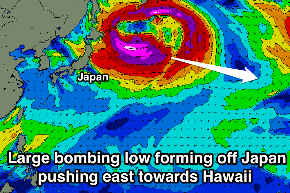
Pointed out in our Hawaii long-range forecast Tuesday, current weather models are now firming on another 'bombing low' forming off Japan mid-next week, feeding off an extremely cold burst of air from Siberia. This will see surface pressure drop from 1000hPa to 960hPa within 24 hours, clearly exceeding the required threshold of a drop of 24hPa within a day.
The most exciting characteristic of this low will be its size and longevity as it pushes east through the North Pacific, only weakening once it's to the north of the Hawaiian Islands (and past Hawaii's swell window).
Also, it's interesting to note that the remnants of the large 'bombing low' in the Atlantic producing the current XXL swell across Europe will move across Russia and feed into the back of the system moving off Japan, increasing the longevity and strength of the storm traversing the North Pacific.
Current forecasts have a very large fetch of severe-gale to storm-force W/NW winds projecting from Japan towards Hawaii and the US West Coast as the low moves slowly east.
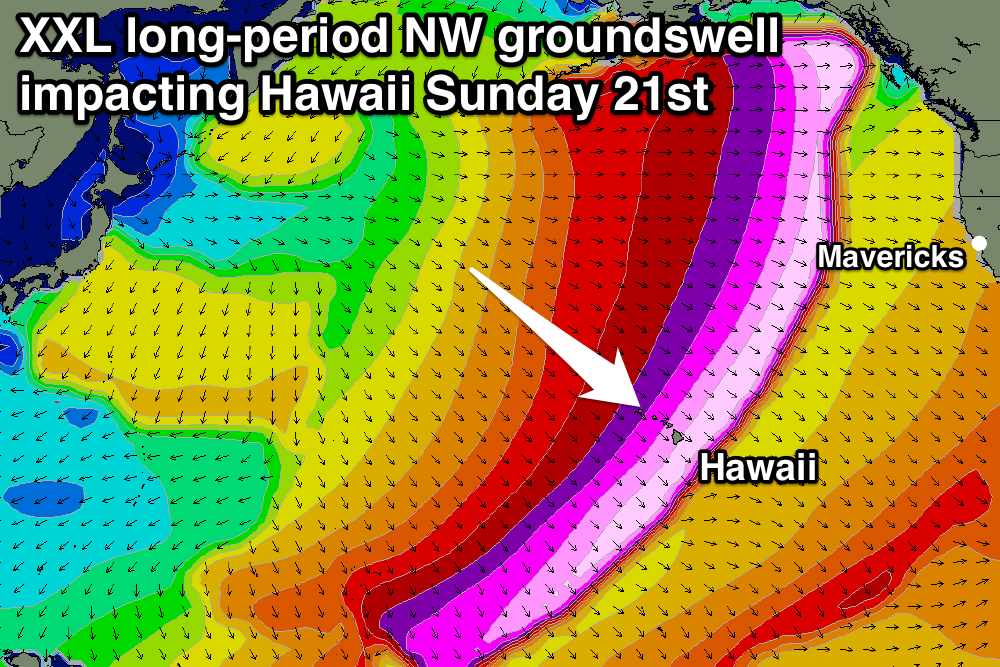
The general rule of thumb for storms generating the required 20ft+ of swell for the Eddie Aikau Invitational is that the storm pushes east past the International Date Line, and current forecasts have it doing so while weakening.
If everything goes to plan the end result should be an XXL NW groundswell for Hawaii peaking on Sunday evening the 21st of December in the 25ft range across Waimea with 30ft+ sets at deep water offshore reefs.
After the swell hits Hawaii it is expected to also travel onwards to Northern California building through Monday and peaking in the 20ft+ range at Mavericks. The swell is forecast to hit California on the evening of the 22nd and peak on the 23rd. Poignantly it was on December 23rd 1994 - exactly 20 years previous - that Mark Foo passed away at Mavericks. Foo had flown from Hawaii to Mavs chasing a very similar swell as this is predicted to be.
Winds at this early stage look favourable for both Hawaii and Mavericks, so it's a very real possibility that the Eddie, and perhaps even the Titans of Mavericks contest, runs. This is on the heels of yesterday's contest in Spain at Punta Galea.
So for big wave surfers the presents are stacking up under the tree. However, as this swell is still over a week away we'll provide running updates on the potential of the Eddie Aikau and Mavericks events over the coming days. Keep an eye on the comments below. //CRAIG BROKENSHA
Comments
What's the favourable wind direction for Waimea?
E'ly to NE trades. If winds go too E/SE they blow up the face.
Sunday 21st super long period swell. Waimea prefers 15-16 secs
Yeah that's right - I remember a couple of really long period swells over the last couple of years that didn't end up doing as much at Waimea as expected, because the bathymetry was focusing the main energy elsewhere. Will be interesting to see what this one does.
Yeah good point Mick, longer period NW groundswells are known to be focussed away by the outer reefs. Will have to wait and see with this one.
Yeah apparently for the eddie to go ahead the head of the fetch needs to be closer to Hawaii from what I recall.
Mentioned above "The general rule of thumb for storms generating the required 20ft+ of swell for the Eddie Aikau Invitational is that the storm pushes east past the International Date Line, and current forecasts have it doing so while weakening."
Thanks Craig. sometimes I don't read all of your waffle!!! ;)
Jeez if you don't read it no one will, haha!
Maybe I'll just put up big bright colourful WAMs and a number forecast of how big we think it'll be and that's it, ha!
Ha ha!!! I think Mrs Donweather would even read it then!!
SN forecast were pretty accurate when I was on North shore last year. So If that forecast holds then Jaws will be in the 40 foot range and have 70-80 foot faces. With the XXL crew ready could be groundbreaking sessions
Why the hell aren't they thinking of running Jaws?
That's where the cutting edge is , that what everyone wants to see.
Its a long way out Steve...but everyone is issuing swell alerts for the eddie including surfline. Wondering if Southey has opinion regarding El Nino 5.5. It's not often on the same day (today) we have xxl waves in two oceans. Also how did RCJ and Maurice go at Nazarre
MC's reply is in the Hercules thread Mick.
Someone rattled my cage . Was ankle deep in kids shit this arvo . ( almost literally )
Yeah ElNino has peaked early and is currently transitioning fast . I wouldn't read much into that itself . The PDO is switching also ( Nth Pacific ) which may have bearing on this Hawaiian season . As for the Atlantic I presume that is AMO related . Of which I'm not that familiar with its impact on Surf . It would presumably have a lot to with the Gulf Stream .
As for 2 events at once.
It's not rare in the Southern Hemisphere , a two nodal LWT will deliver two separate and almost longitudal opposite systems . A two node system has more potential energy than 3 or 4 .
As for the next swell was wondering if 10-11 days is Hercules big brothers travel time to the pacific or the same system now circumnavigating . Either way the uppers are stalling over each oceans western basin !?!!
Is El Niño 5.5 a typo , or is there something I'm not aware of ( an ongoing joke ) I'm usually pretty slow with wit !
5.5 was NOAA forecast on there scale for upcoming northern hemi. interesting as it looks like an above average season with only 2 weeks so far of mediocre waves.
When you say forecast scale are you talking about wave action . Or SST's influence on Atmospherics ?!
BTW .
1967 was a similar year to this year .
Be it a short period of warm PDO in a cool PDO dominated phase , plus in a transition of El Nino to La Nina ......
Wiki - Pacific Decadel Oscillation ( PDO ) .... And in the mechanics section , read the teleconnections to ENSO bit , also the diagram is very informative of how the Long Wave Trough ( Uppers ) tend to stall in the Far Upper NW Pacific . There is another teleconnections to the Atlantic , but I can't find it .
How is the forecasted super bomb swell looking ?
Hi Southey, sorry had the young bloke all weekend so didn't much of a chance to respond in depth.
I check the NOAA site occasionally. The 5.5 was a scale they said for degree of forecasted El Nino for the upcoming Northern Hemisphere Winter.. i.e. 10 being a strong El Nino. I can't find it, was from earlier this year. Mainly I am only looking at the basics - so more the SST's and forecasts.
And really it's just for planning, if its going to be strong El Nino try, will try to get to Hawaii as East Coast will be flat here.
I'm a bit more uneducated on those other parameters, but it's great to read. example last season was really windy with a lot of NE on Oahu in particular....is there any weather specifics relating to this? ENSO for example reports last month low level winds and abnormalities but that's difficult to correlate except from photos and first hand reports.
Really interested in Indo for next year too, have leased a place for 6 months from June so really want to explore. The Indian Ocean has overachieved for the past 18months, so interested in your opinion if Indian Ocean going to stay in form.
Yeah know what it's like . I have two young tip rats .
The ENSO & PDO has more to do with storm formation strength , location and frequency .
Although it does have an effect on trades , it's less defined and maybe has more to do with more local SST anomalies than the overall picture . But not withstanding that it still does have a general effect on averages . Specifically a la nina is more than not attributable to higher occurrence of kona winds . More so on a recovering / waning la nina .
And higher frequencies of light trades and variables in El Niño .
This is very insignificant though .
It's not like the Indian / Indonesia where upwelling and a complex drainage system comes into play let alone continental effects from either Asia or Australia having effects on local winds .
And the Indian swell source is more of a SAM , ACW and less so but still significant IOD influence on storm generation , frequency and location .
None of this study of all /some influences gives you more a chance of scoring .
Early season Indo was a fluke this year , however I have had confirmation by so e guys around here that swore as the season went on the abundance of WSW swells gave way to an abundance of more SSW . But that's third hand reports .
Always interesting Southey;)
Ive been out off Exmouth for the last 8 weeks and only home for 5 days, due for some good time off :)
I remember last Nov and Dec out here was hot as hell and not much wind compared to this Nov-Dec....?
The last couple of months here, there has only been a few windless days but not that warm, every other day it has been howling 20 plus knots from the SSW-W, small period wind swell etc. Have noticed that there has also been alot of moisture in the air, the decks are always wet with due in the mornings even with lots of wind...?
Maybe its a change...? Who knows.!
IMO its totally different to last year and the year before out here. Just a general observation from being out 20 miles offshore in the thick of it.
I was gonna bring this 2 cents of on hand information up in an El-nino thread but Mick Free has sparked it here, my apologies.
Thanks Southey. I have been watching the direction all year and confirm the swell direction change too. Same in Africa a lot of WSW swells May - July. Normally I hate the SSW swells for Indo but now know a couple of spots that absolutely pump on that direction. So its opened a few new search zones.
Yeah Welly, not very hot at all this year. Beautiful.
Unfortunately the low forecast to form off Japan now doesn't looks to be as well structured as it was forecast at the end of last week, with the fetch now looking to split in two.
This isn't good for the Eddie swell potential and as a result forecasts now look to be below Eddie thresholds and more in the 18-20ft+ range.
We'll continue to keep an eye on it over the next couple of days.
But more importantly, will the split low bring a big dump to Japan Craig!!!
Yep still big totals forecast for Tuesday and Wednesday!
Sweet music to my ears!!!
Chaos at Mavericks yesterday.. instagram.com/kyle_buthman
Howz the crowd factor out there?!? Madness!!
Yeah looked absolutely packed, dangerous!