How does forecasting influence crowds?

people who mobile/text their mates and their dogs, when things gets going are way worse

i notice around here if its good for a while especially mid week its often uncrowded even if predicted to be good but if theres only one day in two weeks that looks ok it will be packed.
But if its pumping and no ones out im a bit curious as to why. Happens often here, packed or empty. (mid coast WA)

v. interesting topic.
I've been curious about this for a long time.
Last swell I decided to conduct a little experiment, inspired by DonW , who claimed that uptalking or or even mentioning a size or region could influence crowds. So I decided to do my very best to down talk it, to trash talk it and try and put people off. To see if it might ameliorate some of the effects of the best E swell in months peaking on the weekend. Nah, no effect, or at least none I could discern. The primo point waves were all packed to the gills. There were some quieter options, not many at the peak of the swell due to the SE wind but as the swell eased a few more came on but the Points were still chockas.
I think there' s just so many information sources now that these easily forecast, hyped swells: the ones that stand out like dogs balls are just going to be packed at the good spots.
Thankfully there still seem to be a few under-hyped swells that over achieve, mostly long period souths and tradewind swells that combine with other sources, to allow for some lesser crowded conditions.
Oh yeah, and sharks. That is the only surefire method of crowd reduction in 2015.
Yep, fell for this just recently. Used the usual sources of swell prediction. Planned the drive, added a day, just to be sure. Swell didn't arrive, so heh, what's going on - checked again. Stayed another day. Swell didnt happen , so headed back. Yep, you guessed it, it arrived the next day and the locals would have been happy. Not this little veggie. But I suspect that all sites get their info from a single source.
Hype ? How about comparing it to the party scene . If you often party & your in that scene you will hear about every party & go to them . But if you dont party and you have distanced yourself from the scene you don't get invited , or go . Same with surfing the hype is really just information & your perception of it . If you dont hear or read the info then it doesn't exist . Crowded surf zones must accentuate it a lot
I think it does have a affect.they say 7/10 on the report you go for a surf and the water is busy.then they do 5/10 and its under half the people. But the surf was better.i stopped going off the rating ages ago...

I'm still perplexed at how a surf report (or forecast) 'rating' seems to be the gravitational pull for many punters.
Seriously, it's just a number that's based on a huge range of individual interpretational information. As I've said elsewhere before, Swellnet never had ratings for the first few years - but we were asked by a data client to include them, so we did.
As such I've never felt comfortable with summing up the broader surf community's recreational pursuit with a single number that's meant to quantify large, diverse expanses of coastline - it's just too hard. But unfortunately, the way society consumes data means that we can't ignore it.
In the meantime, I wholly recommend reading the actual surf report, looking at the actual pictures, and reading the written forecast notes too.
I'll say that for a great deal of young surfers, their only knowledge of surf forecasting comes by the ratings. You often hear things down here in the car park: "Saturday should be good, five stars on surf forecast". We also get the big swell hype with southerlies that might light up the points. It's very rare to hear a young 17 year old surfer talk about swell height and period.
I personally don't think it has much of an influence on crowds in our neck of the woods. The biggest influencer of crowds at any given spot is the bastards who call and text their mates to descend on a spot. Instagram and FB are the main facilitators, and you routinely see the young blokes who turn up in groups of 4 as it is post photos on Facebook and tag their mates saying "yeeewww it's on boys". I'm even guilty of checking the instagrams of certain surfers to see what the waves are doing haha.
Couldn't agree more DDD.
I've been a big critic of the ratings, not because of it's effects on crowds, just because it is so often farcically inaccurate.
Best example was last year, day of the winter; local Point as good as it gets. 2 or 3 barrels on every wave and the SN report gave it a 4/10. Effect on crowd? Nil. Carpark was packed, surf was packed. Word spread so quickly that the report rating was effectively meaningless.

FR said "Last swell I decided to conduct a little experiment, inspired by DonW , who claimed that uptalking or or even mentioning a size or region could influence crowds. So I decided to do my very best to down talk it, to trash talk it and try and put people off. "
Accolades too you FR as I had a feeling that whole forecast thread you were achieving something, but not a little experiment. Haha.
Surely took old Sheepio for a freeride...
Ben said "I'm still perplexed at how a surf report (or forecast) 'rating' seems to be the gravitational pull for many punters..... "In the meantime, I wholly recommend reading the actual surf report, looking at the actual pictures, and reading the written forecast notes too."
TonyB so did you read the written forecast notes?
Shame on you eh;) what a waste of petrol and planning.
I feel for ya...
Maybe next time take Caml's advice with period and direction of the swell from the buoys.
"hype is really just information & your perception of it . If you dont hear or read the info then it doesn't exist"
Nah don't bother reading the buoys or the forecast notes just go on a journey, waste some petrol and time having a happy happy joy joy of a time time... ;)
Harha fr I like that . I haven't seen this"rating" and im probably not going to , but where would surfing be without frothers & hype ? Pretty boring
I think most of you know my thoughts about this topic. I've experienced it first hand, both over-hyped swells and under-hyped swells. I know which ones I now prefer to surf!!!

"Last swell I decided to conduct a little experiment, inspired by DonW , who claimed that uptalking or or even mentioning a size or region could influence crowds. So I decided to do my very best to down talk it, to trash talk it and try and put people off."

Anyhoooo, just keep your eyes on the gulf, as I told all of you "experimenters" a few weeks ago... Enjoy your forecast notes...
Well I guess the general consensus is that the 'rating /10' means nothing and I've actually never looked at that. I reckon the photos are borderline pointless also as they're just a snapshot in time and usually not from great angles.
I know my coast and what the banks are doing and what it needs so I appreciate the 'Surf Forecast section' where it predicts swell height (m), period and direction……I reckon that's a massive help and all you really need if you have any surf / ocean knowledge.
What gets me more is calling 4-5 foot a week out when for example this swell today is 2 foot, maybe 3. Wouldn't it be better to pump the breaks and only give specific swell height forecasts when it is fairly certain?
Erm, who called 4-5ft a week ago? And for what coast?
The idea of the forecast notes is to provide the best possible outlook given the information at hand, but that doesn't always play out as expected. It's the nature of the forecasting beast.
Sheepdog wrote:Anyhoooo, just keep your eyes on the gulf, as I told all of you "experimenters" a few weeks ago... Enjoy your forecast notes...
Nothing to see here. Ya can all move on now please!!!

Liking the look of some of these forecasts.. Just a matter of where it sits, looks to be more around the Tropical North.
Sure a gulf TD or cyclone is nothing out of the ordinary... mostly they track into the QLD interior, fizzle out in the Cape or head back into the NT, nothing to get excited about there unless you're a farmer or got a banana prawn licence for the gulf.......it's much, much rarer for them to track into the CS, reform and become swell producers.
Thats a totally separate kettle of fish.
Is that what you are calling SD?
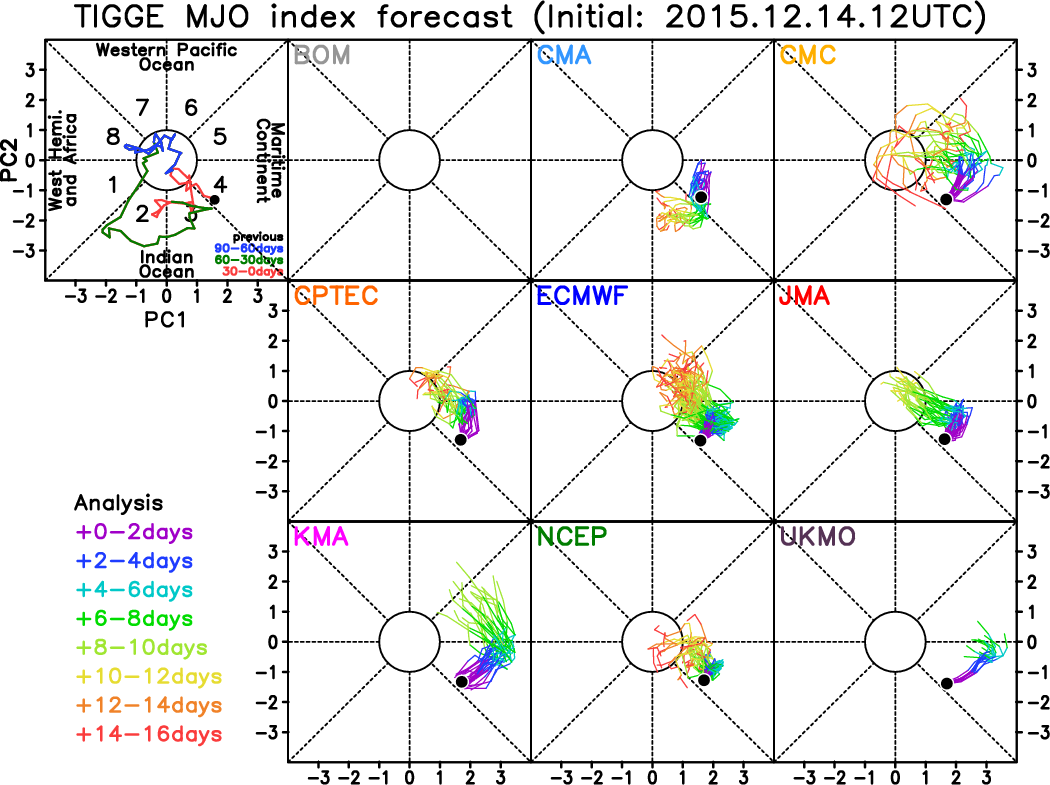
Take your pick on those MJO model forecasts Craig, some of them are good, some meh....I haven't been tracking the models to see which one has been resolving the MJO the best lately. Have you got a preference?
Sheepdog wrote:Enjoy your forecast notes...
"Wow" Sheepio....
The forecast notes are for you to read and enjoy as well Dawg..... ;) Work as a team IMO.
The funny thing I laughed at, is some comments during that thread of " Forget Tues and Wed; Thurs onwards looking great for the points" and " Here comes the East swell", extremely amusing.!
As everyone seems to be better at forecasting surf, winds etc, than the bloke who is forecasting....?
There is always someone better and bigger than yourself in any realm, no matter what it is.
wellymon wrote:There is always someone better and bigger than yourself in any realm, no matter what it is.
Does this apply to God?
Craig wrote:Liking the look of some of these forecasts.. Just a matter of where it sits, looks to be more around the Tropical North.
Love the CMC one......can't go wrong with their forecast!!!
UKMO going WAY out there!!!
donweather wrote:wellymon wrote:There is always someone better and bigger than yourself in any realm, no matter what it is.
Does this apply to God?
.
Fuck knows, who is that?

Try spelling it backwards. I'm sure he'd agree.

Yep, simple solutions folks - jamming technology along the coast, near carparks, headlands and points especially so punters can't text, or upload pics to facebook or instagram while standing in the carpark. Let's start a crowd funding campaign!
Serious though, it is the 'word of mouth' factor that kills good lineups. East coast shifting sands and and beach break conditions means a "good bank" will form in various locations, and at times it can stay uncrowded for quite some time - I've come to learn who the locals are around here who can't keep their mouth shout, they discover the set up, and well, the next day the crowd grows, and the day after, with all their mates - it's then I head off to find the next good set up ;-)
wellymon wrote:Sheepdog wrote:Enjoy your forecast notes...
"Wow" Sheepio....
The forecast notes are for you to read and enjoy as well Dawg..... ;) Work as a team IMO.
The funny thing I laughed at, is some comments during that thread of " Forget Tues and Wed; Thurs onwards looking great for the points" and " Here comes the East swell", extremely amusing.!
As everyone seems to be better at forecasting surf, winds etc, than the bloke who is forecasting....?There is always someone better and bigger than yourself in any realm, no matter what it is.
Spot on, welly... And Ben got it just about right, 11 days before the event.... yeah, 24 hours out, but a fuckn good long term call..... He didn't "experiment", or flip flop.... Stuck true to his call,....
Don, "nothing to see here".......
Really.... With the greatest respect, mate, the whole mjo/ gulf/pacific setup is like an orchestra, in laymans terms.... Alot of amateur swell watchers focus in on "one instrument", and not the whole band, so to speak.........
At the moment, we have a deepening trough over inland NQLD..... As I explained a few weeks ago, these setups can occasionally be quite conducive to Gulf lows.... Now... As one instrument in the "orchestra", it of course can't produce swell for SEQ..... But as a band member, it can help set things in motion.... There's a good chance a tropical low will form in the gulf...... The monsoon trough will of course run through the low.... As the low drifts south, so to will the monsoon trough..... Some charts have this low as fr south as 23s'....... This means the monsoon trough will be running west east from Mt Isa to New Cal' and beyond..... The monsoon would not be this far south without the gulf low's influence... This in turn set's up more possibilities......
Now a best case scenario for this system, and for SEQ, is an ese track over the qld coast......... The worse case scenario is actually still quite good..... Thanks to the gulf low, evenif it remains over inland qld, it will place the monsoon trough in prime position over the coral sea... This in turn will invigorate a ridge....None of this would occur without that low dragging down the monsoon trough...
Have a look here, Don
http://www.metvuw.com/forecast/forecast.php?type=rain®ion=swp&noofdays=8
freeride76 wrote:Take your pick on those MJO model forecasts Craig, some of them are good, some meh....I haven't been tracking the models to see which one has been resolving the MJO the best lately. Have you got a preference?
Me neither sorry, will have to keep a close eye on proceedings this summer.
Here, Don.... One possible scenario re' the "orchestra", and not just the violin lol.... I'll explain it in very basic laymans term, also know as wellyish, or wellymonese.... ;)
1- low forms in gulf..

2 - low deepens and moves south - a big chunk of monsoon scud , thanks to the low breaks off near townsville... Isobars bending over great divide, and tasman high in prime position.....

3 - Low, monsoon scud, firmly in place, ridge deepening, scud may interact with more minge east of Solomons....

4 - Thanks to gulf low, monsoon trough firmly established across coral sea.. Small secondary tropical low has formed... Pressure squeeze between monsoon trough and tasman high..

5 - Gulf low and secondary pacific low has trough firmly entrenched... Impressive trade fetch established... And that's a worse case scenario, all thanks to our little maestro in the gulf getting the orchestra to play..

As for surf REPORTS contributing to crowds, well that really depends how early in the morning they are available. A quick glance at today's reports from the sydney area has reports updated anywhere between 5:45 and 7:45am. Let's face it if you've slept in till 7:30am this time of year you've already missed it and will be lucky to beat the seabreeze, especially if you have to travel say 30 minutes + to your chosen location.
It's the FORECASTS that lure clued in surfers to congregate en masse at out of the way locations at the crack of dawn, they're planning on being in the water well before the first reports come out. Personally I have very fond memories of one pre-dawn road trip down to bawley point for a much hyped swell that wasn't even worth paddling out for (unexpected onshore wind). And why would I be happy about that? Because it was worth it to see about a hundred other guys standing around in the first glow of light (scattered between 3 or 4 breaks) with disappointed looks on their faces thinking "F$%K, what do we do now??"For me that was a better outcome than if the waves had been pumping and ridiculously crowded.
So in summary if the forecasts weren't available or maybe just very basic like the BOM coastal waters forecast, then more surfers would choose to wait for the reports or have to at least drive around a bit more checking locations and you may not have as many out of towners swarming to a particular wave at first light.
talkingturkey wrote:Try spelling it backwards. I'm sure he'd agree.
Haha, Is he also known as the conductor of the orchestra!
Especially when playing the flute and the triangle goes .......D i n g g g g g g.......
wellymon wrote:talkingturkey wrote:Try spelling it backwards. I'm sure he'd agree.
Haha, Is he also known as the conductor of the orchestra!
Especially when playing the flute and the triangle goes .......D i n g g g g g g.......
"Conductor"????? Fuckn Maestro to you, buddy.......
Swells from systems covered by BOM would not be affected crowd wise IMO..... However, the old "mysto swells", those swells that caught everyone by surprise in the 1970s/80s and part of the 90s, the long period stuff from out beyond, I reckon they would have more of a crowd on them now.... I mean in 78', when a cyclone formed in Australian waters and moved into the SEQ swell window, everyone from Bells to Agnes knew about it..... But a Cyclone and associated fetch way out beyond Fiji generally wasn't covered back then, thanks to no world wide web.... Scored many epic "mysto swells"...... But now they're dissected 7 days , even 11 days before arrival.....
I've got to agree with you there dog, back in the 70/80s many times we could get great waves at Lennox 1st day of a swell with next to nobody out. 2nd day of a swell the byron crew would turn up and then 3rd day we'd get the Qld crews hitting it but now they're lined up on the rocks before the swell even hits!
Partly swell forecasts being too accurate but a lot to do with mobile phones and punters wanting to surf with all their mates rather than having a sneaky sesh by themselves.
Fark, we used to love sneaking off someplace and getting uncrowded waves then telling blokes they missed it but not telling them where then sneak off the next day too!
"I've got to agree with you there dog"......
Jeezuz.... We'll be standing under the mistletoe together, next..... Stop it seal... Ya makin' me feel uncomfortable bahahaha.... ;) ....... Yeah, those "mysto swells" were the go.... Seal, with the close range cyclones back in the 70/80s, in some ways the crowd was a lot more intimidating, especially at Burleigh, where a pretty heavy local crowd used to rule the roost.... I was a north end grommet, and used to catch the first surfside bus down to burleigh..... Seen a few blokes have their 70's surfy hair held whilst copping some severe uppercuts.... As a 14yo grommet, you knew your place.... We certainly didn't make too much eye contact with the older guys.... One morning an older bloke named Dave McDougal waved me into a gem.... Dunno why.... Still dunno why.... He ripped....Didn't really know him.... Maybe he was hungover or something....But wow.... I thought I'd won the stubbies... lol....
I tend to look at the synoptics myself and make my own judgements, and then see the forecast notes to see what they say about it just as confirmation. If it isn't in the forecast notes then it's usually because I am relying on one model and Ben and crew check much more data from many sources.
But still, the forecasters rarely pick up on something that I can't see for myself, but they will tell me when there is model divergence so I can guess that the likelihood is reduced.
The forecaster notes only come out every 2 days, so if I am going to be available for a surf in some given future, I'll be checking out the 12 hourly synoptic updates.
I very rarely look at the daily reports and ratings, and have gone to the beach a few times to find the report didn't accord with my thoughts on the quality of the swell.
On the other hand, my local is Maroubra, so it doesn't matter, it's gonna be crowded anyway. Summer is for surfing out of Sydney.
["Conductor"????? Fuckn Maestro to you, buddy......."]
That"s really rude and disrespectful Sheepio I don't have Aids at all, so please don't call me buddy!!!
Welly to you please.
As in layman's terms, that also is so rude and disrespectful.
I find in many of your posts once you get the wrong end of the stick (sorry for the pun), you go on the offensive and bag out people at your own will....
Just relax a little, sit/lie down, have a scratch if you want but you don't, in no way have to discriminate people at your own will just to make you feel like you're the top dog spelt backwards.
Please next time you bring up orchestral weather maps get some archives you've saved from the past?
It might make sense in layman's terms.Anyways Staitey,Definitely not a gripe just food for thought. I'd be interested to hear others opinion…………
I like to use scientific words until the moment that I don't understand the word then get frustrated if it isn't in laymans terms . Theres forecasters words & carpark words & more too , english is confusing
wellymon][quote=Sheepdog wrote:["Conductor"????? Fuckn Maestro to you, buddy......."]
That"s really rude and disrespectful Sheepio I don't have Aids at all, so please don't call me buddy!!!
Welly to you please.
As in layman's terms, that also is so rude and disrespectful.
I find in many of your posts once you get the wrong end of the stick (sorry for the pun), you go on the offensive and bag out people at your own will....
Just relax a little, sit/lie down, have a scratch if you want but you don't, in no way have to discriminate people at your own will just to make you feel like you're the top dog spelt backwards.
Please next time you bring up orchestral weather maps get some archives you've saved from the past?
It might make sense in layman's terms.Anyways Staitey,Definitely not a gripe just food for thought. I'd be interested to hear others opinion…………
Have you got anything to say about the possible meteorological scenarios, wellymon? Anything at all? Or perhaps maybe just don't bother about the topic..Perhaps you could bring my wife into it, like blowin did.... Laughed at his joke , wellymon? Good one was it? Anyhow, give us your interpretation of the next 7 days..

Remember your job on Uplift a few months ago Sheepy?
Now that was personal.
Aaaaand the bait has been taken..... Ok, andy, run us through the event..... Start with Uplift making up stories about my wife, my profession.... The I'd like you to detail his outlandish accusations about southey, which is what that little scenario was all about... The floor is yours.....
Ps - at no time did I demean his ex wife..... And as I said to uplift, I'd delete the post once he had read it, which i did 15 minutes after posting..... The post about my wife, not ex wife, has not been deleted..
As I said, the floor is yours....
Yep...... As I thought, Andy....... Do you want to stir shit and munch popcorn and do crowd experiments? Or do you want to talk about,,,, say a maritime airmass, or cross equatorial flows invigorating monsoons, potential for slow moving troughs over warm water?

Guys calm down and have a snickers ... " you get angry when your hungry. " ......
Sheepo you can get orchestral , but to me the MJO progression is what separates or takes that initial gulf trough / low moisture out east . It's plain and simple the MJO for most of the time is a form of atmospheric tide .
It's a meal , the initial surface conditions in a broad region , ( the size strength and locations of highs , troughs , lows etc ) is the ingredients . In summer the MJO is the steam oven . How long and what power setting is up to it . Yes it appears sheepo is the chef . I'm hungry , who else wants a dish . ;-)
Whilst all you guys are getting all lathered up over some tropical soup , I'm eyeing something else off closer to God . ( oops sorry I mean agent Bourne ) .
For sure Sheepio.
The next 7 days will be similar to the last up here.
2-3ft trade slop from the east with se-ese-ne winds.
As regards crowds well thats another story when you constantly say about the long range swells coming from way outside of our window friend!
Quote Sheepio "However, the old "mysto swells", those swells that caught everyone by surprise in the 1970s/80s and part of the 90s, the long period stuff from out beyond, I reckon they would have more of a crowd on them now...."
Well the truth is that you are the man on here talking about them so much;)
Thats for real, so chew on that like an old rotten bone.
Was going to say the MJO is the bass line in the orchestra but Southey just said it.
Never said anything at all nancy pants about your lovely wife, I just laughed because you get all wound up chasing your tail that has a tick on it.
Sit down and stay.
southey wrote:Sheepo you can get orchestral , but to me the MJO progression is what separates or takes that initial gulf trough / low moisture out east . It's plain and simple the MJO for most of the time is a form of atmospheric tide .
.
Exactly Southey.
SD put the cart before the horse saying it was the gulf low that dragged the MT trough south. The gulf low is a result of the monsoon trough being activated by the advancing MJO phase.
He's partially correct , but look further south also , you have a trough /low / front progressing East too at roughly the same time . The combination of the gulf low and the MJO is also what draws moisture into towards the Qld coast from out east of the solomans this combining with the gulf low interaction with the passing MJO .
The MJO acts like a giant wave or atmospheric tide and will actually (just like a surfing wave) drag things out towards it (west atmospherically ) before carrying everything combined back towards shore ( East atmosperically ) . I wasn't here to correct anyone in particular , more so opening minds and adding a little distraction to the heat induced troppo symptoms leaching out . Shit Humour is my only form of diversion . Apologies in advance . No quokkas were harmed in the production of this post .
hahahhaha, we're all just kicking cans down the road .
Wellymon, I've hardly partaken in forecast notes for months.. Agreeing with ben on the last long range swell was my first interaction in ages... So your "Well the truth is that you are the man on here talking about them so much;) Thats for real, so chew on that like an old rotten bone" ------is just bullshit.... Go back and check the forecast notes..... Months, man..... And this is a swell forecast site right?... What do you expect Ben, or Craig, or Don, or Steve, or me when i choose to, to talk about on a swell forecasting site? Now even the crowds are dawgs fault..... Fuckn hilarious......So apart from hanging with the in crowd and joining the free ride pack, what's your point really?
Southey... It's all an interaction.... There's been a semi permanent inland low now for ages, which i went into detail about in forecast notes 2 weeks ago, where I stated the next tropical low will develop in either the gulf or Solomons, which of course was scoffed at when i wrote it...
27/11/ 6.46pm - "Totally unrelated - IMO, 2 spots to watch over the next 4 weeks re tropcal low development is good old reliable solomons - not exactly going out on a limb with that one lol.... But I think eastern side of Solomons.......
The other thing I'd watch for is the Gulf..... In particular, I'd watch for an odd development - A "land low", or deep trough over Qld/NT moving north, being pushed pushed northwards by an early season larger than normal high.... As the dry low/trough encounters the 29'ish warm waters, anything can happen.."
6.50pm "These quite rare lows can often turn cyclonic, head ese crossing the cape or even below (townsville), and then deepen again in the pacific..".......
On the 1 december, , the scoffing began..... Some bright spark wrote this to me;
"But put your panties back on and tell us if you see anything looming in the Solomons or Gulf. This goose is cooked.".....
Well...... I'd like to say , YES.... i do see something looming........ lol.....
Now, Southwald........ Now no more private investigators, mate..... Fuck i copped it in the neck for going in to bat for you buddy lol
Just a thought I had recently. I guess off the bat the obvious answer would be yes. I like most surfers these days use forecasts such as on this site however I wondered the effect it has had on surf crowds.
I have found swells such as the last one and many before tend to be called so far in advance these days and I wonder whether the hype out weighs the event.? Coastalwatch will put up a one week banner 'EAST COAST SWELL ALERT' as though there's some need to run for the hills or go out an buy the latest Seadoo model.
I'm not sure if it by design or due to our insatiable need for information but what would be the advantage of over predicting swell and broadcasting them so early? Obviously things change as the models come more into alignment closer to a swell but it seems more often then not many swell events end up being downgraded and punters get a little disappointed (or is it the crowds that disappoint?). So as such does swellnet (and the likes) ever consider being a little more vague or conservative with these long term forecasts (i.e 'there could be an a better than average run of swell for next week') ?
I personally avoid crowded places for quiet beach breaks more often than not so crowds rarely effect me but I thought imagine the times when people didn't have a week to prepare for a swell and those on the pulse got lucky.
Definitely not a gripe just food for thought. I'd be interested to hear others opinion…………