Beaches Covered In Dead Stinking Fish

Yeah it's hard to imagine that the Desal plant isn't connected in some way. Craig's much more well versed on the gulf currents, so I'll let him comment further - unfortunately I don't know anything more about the situation (although I'll have a look around).

I heard a radio news story (ABC Radio National, so it has some credibility) that the fish kills had started in waters off the Eyre, and later moved over to Gulf St Vincent. I'm not sure how far the influence of the desal plant extends, but I'd imagine it's not quite that far.

SurfSouthOz have a couple of theories here - http://blog.surfsouthoz.com/?p=79

Hi Willywag, it's hard to lay a cause as I don't have all the facts in front of me but just some pointers about the Desal Plant that could be part of the blame.
The natural circulation through the gulfs is clockwise in direction, ie Southern Ocean water enters the western sides (Port Lincoln and Edithburgh respectively) then travels north around to the top and then down the eastern sides (past Innes NP and Adelaide respectively) and then back into the open ocean as per the diagram below.
In my study we placed brine concentrations at the proposed Desal outlet locations in Spencer Gulf (off Point Bonython) and Gulf St Vincent (Port Stanvac). The release rate and concentrations were adjusted to the proposed brine output from the Port Stanvac desal plant.
What you can see in the below diagram is that the brine follows the natural flow of the gulfs circulation, ie down the coast from Port Stanvac, and up and then around and down from Point Bonython.
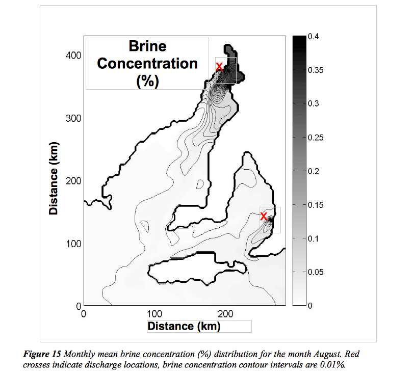
Interestingly in your observations you noted that we are only seeing the fish dying in the Southern Adelaide beaches and this fits in with the area the desal output brine would affect, as with the circulation being down away from Adelaide, Semaphore and further north would be unaffected by the brine.
So in this case you could say that the Desal plant could be a major contributor.
The problem in the SA gulfs is that they are highly saline by nature in that evaporation far exceeds fresh water input resulting in very salty briney water.
Add to this limited circulation to the open ocean and you get very high salinity water at the end of the gulfs and less saline water at their openings to the Southern Ocean.
The gulf in its natural state has always been this way but when we introduce additional salty water into the already highly saline environment it can't be good.
There's also the 'dodge tide' phenomena which sees little to no tidal movement every 14 days, and this is the main problem with the desal plant, as the dispersion of the brine depends on strong tidal movement past the plant. Every 14 days this vanishes and this can lead to a build of brine in the outlet area which could lead to fish deaths.
I can't make a call on this, as I know the water temps have been slightly above average and with no major mixing a large algal outbreak could starve the fish of oxygen but I guess more tests need to be done around the new Desal Plant.

I'd be interested to know the if the loss of sea grass that washed up at Glenelg, and the death of bottom dwellers had anything to do with each other. I'd also be interested to know if that sea grass loss was from the Desal outlet area. The mid and metro coasts get sea grass wash up periodically after SW storms, so sea grass loss is not unusual.
There just seems to be a number of coincidences (and assumptions) that point to Desal being part of the problem.
Craig, If the larger flow of the gulf is clockwise, then why & how is inshore flow northward?
Does the Desal brine outlet project past a point to which the flow is southward (as indicated in your diagram)or is it still in the northward flow? Does the brine that is discharged stay on the bottom as it disperses? (Salt water is heavier than freshwater so it would stand to reason) Could there have been a greater concentration of salt in the brine at the time the Desal cranked up?
If all these things turn out that it all points to the Desal starting up, could it all just be a one off, and we shouldn't be too worried about it?
Hi Ben, the general circulation is clockwise, and sorry I should of said but that second graph is bottom circulation, not surface.
There is longshore drift during swell events and sea breezes to the north along the Adelaide coastline but this is close inshore and limited in depth I'm pretty sure.
The brine is released at depth but is meant to be 'sprayed' out along a pipe line so it dispersed quickly into the surrounding water column. The tidal mixing is supposed to help this process further. So yes it will stay at depth and build up during low tidal cycles/movement.
The concentration of the brine is twice that of the surrounding ambient ocean water!
Say you have 1L of ocean water, 43% is turned to fresh water (yes less than 50%) and the remaining 53% is returned to the ocean with twice the salinity.
That is the problem with Desal Plants, they are hugely inefficient, costly, wasteful and bad for an area that has low wave/current/tidal energy.
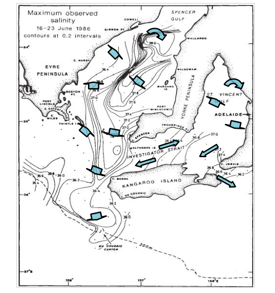
thanks for your replies guys. Craig the above diagram showing the dispersal of saline water is very interesting. Is this published material, because if it is the goverment should be showing the public, but guess what....crickets. This whole thing stinks more than Southport beach last week.
You'd hope they were aware of it, and yes it's published. Keep in mind that second diagram is the 'forecast' brine outfall from the Desal Plants and it may spread slightly different to this (but you'd be safe to follow this as the general pattern).
The first diagram shows the contours of the 'observed' outflow of highly saline bottom water from the natural circulation during winter.
The gulfs are quite dynamic and interesting water bodies in my opinion!
Yeah Don, as per my first post..
I can't make a call on this, as I know the water temps have been slightly above average and with no major mixing a large algal outbreak could starve the fish of oxygen but I guess more tests need to be done around the new Desal Plant.
By: "craig"
Don, the article indicates algal blooms as being responsible for the deaths, and I can understand that for dolphins and penguins, but not so for bottom dwellers.
Perhaps I can be educated as to how an algal bloom affects different depths of ocean.
From my limited knowledge the oxygen is only added to the water column through mixing and absorption at the surface (other than an underwater thermal vent in volcanically active regions).
So if an algal bloom occurred this would stop the oxygen getting into the water column and hence effect every living fish and mammal through the entire water column, top to bottom.
Any Marine Biologists out there?
Surfstarved, what species of fish were reported a being washed up. Were they bottom dwellers, I know f all but saline water sinks, the chemicals in the membranes they use in desal most probably sink. The fish deaths are bottom dwellers, no reporting of gar, Tommies.an interesting side note, from my observations salmon have not been affected. Salmon can tolerate water higher in salt content than allot of other fish species.
Not a marine biologist but an algal bloom would both use up oxygen due to bacterial respiration as well as block sunlight from penetrating the water. The loss of sunlight on the ocean floor would inhibit photosynthesis, which stops plant growth (things like sea grass). Maybe some of the bottom dwellers depend on plant based food sources.
Algae (phytoplankton) are plants and photosythesise in the light, producing oxygen...It is true that through respiration in the dark they consume oxygen which may lead to oxygen depletion. This is exacerbated during the decay of a bloom due to the action of bacteria. For this to be a big problem however, we would need to be seeing a HUGE bloom across the gulf, of pea-soup proportions and it is just not there......
Willywag - Sorry, the report was about a week ago and I'm not even sure if they went into that much detail. Anyway, I had too many bad habits in my teens, so the memory's not all that flash at the best of times.

Quite a technical question related to the gulf's etc... Why does the mid & victor suck so much in comparison with the rest of the state? Strictly speaking swell/wind angle relationships and reef/sand drift? Any other complications/issues/bathmetry? I know there are far better places to surf as does every other SA surfer but is there a definitive answer on how we can better understand our coastline? How long's a piece of string i hear you ask...
In short (as this is worthy of a separate thread) - the Mid's problems are related to bathymetry and a narrow swell window.
On the other hand (and keep in mind I'm no expert on this), in my opinion Victor's problem is all related to its geology.
Take a look at the map on the link below, and consider the coastal coverage of each geological province. You'll notice that it dices various parts of the state into similar surfing regions - and that Victor is in a world of its own.
Also note that the Mid - which has some bloody good shaped reefs, despite the lack of swell - shares the same geology of Yorkes.
http://www.minerals.dmitre.sa.gov.au/geological_survey_of_sa/geology/geo...
The same can be said for other parts of the country - check out the geological makeup of other states and you'll notice some similarities where regions of good surf breaks start and finish.
Wow, that's a pretty amazing diagram Ben, definitely goes someway to explaining possibly why the South Coast is the almost coast!
I'm not sure I'm totally understanding your comments above Ben? Are you saying that swell is affected by the geology (ie rock type) of the ocean floor?
No, its a reference to the poor quality wave setups around Victor Harbor. The region is open to a lot of swell but there's only a handful of reefs (all of which are pretty ordinary on a national scale) for a reasonable length of coast, and the beaches are very flukey.
Meanwhile, surf locations just a hundred kilometers away (as the crow flies) are insane. This is due to the local geology, which the linked map shows perfectly.
If you know the South Coast of NSW, grab a local geology chart and have a look at the characteristics there too. It highlights several other surf zone boundaries. I haven't had time to look at many other locations but will do so over the coming days.
Thanks Ben, but I'm still not understanding what your link between local geology and good waves is? Can you explain what you think the link between local geology and waves is? I would have thought it's more linked to local bathymetry than actual geology.
It's the local geology that makes up the reefs and beaches we surf on.
For example, certain rock and sediment structures are shaped by thousands/millions of years of wave action into excellent quality reefs, while other differing rocks/sediments in similar wave prone areas fall short of quality/shape.
So whether this is all due to the different geology in each area and one can get better shaped reefs off one type of rock/sediment than another.
Thanks Craig. Not knowing the areas that you guys have been referring too and relating that to the geology image that Ben posted above, can you guys tell me the two geological types that Ben is referring to above and note which one gives the good waves and which one gives the bad waves.
Don, it really doesn't matter. We're way off topic anyway - probably best to start another thread if you're really curious about the rocks of the Fleurieu Peninsula.
So, back to the fish. All dead, eh?
Back off topic (briefly)... I read somewhere (here?) that the angle at which the sedimentary rock layers of an area lay influences reef break quality. Sydney's sandstone is at fairly flat angles which allows decent waves to form. Places like Port Stephens and other areas of MNC I've seen rock angles of 30deg and the layers tend to be jagged... crap for waves.
As you were...
Yes, that's very true B (I've read about it as well, and it certainly makes sense). Well worth another thread or an article.
Not sure if this was posted before, but PIRSA have set up a "Fish Mortalities Response" webpage. Worth keeping an eye on.
Latest article on Adelaide now confirms that four more have washed ashore - two at Yorkes, one at West Beach and one at Outer Harbor.
This debunks the Desal theory, but still - it'll be very interesting to see what the final report says.
http://www.adelaidenow.com.au/four-more-dolphin-carcasses-wash-up-on-our...
I agree the spate of dead dolphins is weird, we will have to wait to find out what the 'experts' say is causing it and I suppose trust their explanations. The government is running with the story of high water temps etc causing low oxygen levels in the water, I'm no marine biologist, but dolphins breath air don't they? How does low oxygen in the water affect them? In addition the story that says the last mass fish kill was on Good Friday is crap. I've seen loads of fresh dead fish washed up since Easter. Friday just gone i saw about 30 big angel fish washed up on southport beach in the space of about 30 metres, all had clear eyes and looked healthy except for being stoned cold dead. The number of dead cow fish on the beaches is mind blowing, I never realised there were that many cow fish out there, now apparently there is not. They are all above the high tide mark drying in the sun along with the leatherjackets, strongies, puffers and snapper etc.
Oceanographer Professor Jochen Kaempf from Flinders Uni has put together this graph that will take a little explaining but is quite interesting.

Shown is the EPA observations of salinity 100m away from the the Diffuser that outputs the brine discharge.
The light blue line is the ambient (natural) salinity level.
The olive, purple and dark blue lines are the measured salinities at different points during the Port Stanvac pumping cycle.
The red line is the maximum allowed additional salinity during discharge and is always 1.3ppt above the ambient (so legally the plant can't go above this line).
During normal discharge (the first 10 days of March) the salinity is around 0.5-1ppt above the natural levels. You can see though that between the 13-17th of March the levels returned to the ambient levels indicating that the Desal Plant was turned off and nothing was discharged.
Now the interesting stuff comes in around the 22nd of March where the recorded salinities fall below the ambient levels. How can this happen if only briney water is discharged from the Diffuser?
The only plausible reason for this is that something other than brine was discharged into the gulf (diluting the salinity of the surrounding water), and with the Fish Kill occurring at a similar time it looks like it could of been a pollutant. It could of also been 'fresher' less saline water being released, but why would a Desal Plant be dumping out fresher water than it is taking in (this defeats the purpose)?
It will be interesting to see the reaction to this graph and hypothesis on why salinities fell below natural levels from the 23rd of March.
Interesting indeed. I wonder what PIRSA have to say about this?
I was at the rally at Porties jetty on Anzac eve. The government wheeled out some heavies to support their agenda, with some notable absentees in the ministers responsible Gago and Hunter. Basically they repeated the same thing over and over again regardless of the questioning from the public, which was the fish and dolphin deaths were totally unrelated and had nothing to do with increased production at the desal plant and all to do with an algal bloom and virus. I talked to our local member and he basically told me I was a conspiracy theorist and dreamer to think that the desal has any fault in the deaths and that the plant should have been built at Cape Jervis to minimise the damage to the marine environment. I have been banging on the theory that the deaths may have been caused by the desals plant membrane's being washed out, now a researcher has said this may be a possiblity. What will the government say now? F-All they will run with the story that suits them and their agenda ie GETTING RE-ELECTED. Professor Jochen Kaempf also noted last night on telly that the discharge and fish kill also coincided with a DODGE TIDE. How suprising. Maintain The rage people!
Dodge Tide!
Thanks for pointing that out Willywag, totally forgot about that when looking at the charts.
For those unfamiliar with the tides in SA's gulfs, every 14 or so days there's no tidal movement through them as the gravitational forces from the moon and sun cancel each other out.
This is the worst time to be dumping anything into the gulf as it is allowed to sit there and build up with the lack of tidal mixing.
This was the big killer in my studies and I'm pretty sure there are restrictions on discharging through dodge tides..
Craig, where is the ambient salinity levels measured with respect to the desal diffuser outlet as I note on the graph above that the ambient levels jumped around the fish kill.
And I'm no scientist, but if there was an algal bloom in the water, what impact would this have on the salinity of the water? ie would it reduce the salinity as shown by the graphs above.
Also, why has the purple line not recovered like the other lines have trended post fish kill?
To me there's still too many unanswered questions to be pointing the finger?
And Willwag, if they were washing out the desal plant's membranes, wouldn't this be even more saltier than normal due to the salt being captured in the membranes?
Don, I'm no expert but I would say that as desalination works via osmosis the salt would not build up on the membranes. The fresh water would difuse through the membrane and off to storage leaving a salty brine that would be pumped back out into the gulf. The theory I have is that although the desal has been operational (testing etc) for some time the plant has never been rampt right up, therfore all the membranes had not been used. I know in my industry (wine), membranes and filter cartriges must be cleaned out of all chemicals etc used in their manufacture, as well as chemicals used for their storage. You cant just leave these things drying out they must be stored correctly to preserve their integrity. It is this stuff that may have been washed out, with fresh water prior to the increased production at the plant. In saying that I may be totally off the mark and happy to be put straight.
i just googled - chemicals used in desalination- very interesting.
Don, I'm not sure on all of those questions, but I'd say the ambient is taken well away from the Diffuser in a totally different area, possibly kilometres away.
And that small spike in the ambient salinity is due to the dodge tide. The lack of tidal mixing has resulted in a small build up of saline water.
Not sure on the other questions sorry, and I'm not pointing the finger. It does seem that something fishy happened around the 22-23rd of March, and this is at odds of the Government saying the Desal Plant has no part to play at all in the fish kill.
Another hypothesis could be that the chemicals discharged into the gulf could of set off the algal bloom? Sill a lot of unanswered questions.
Craig and Ben, as you guys probably have a fair understanding of the currents etc that run through Gulf St Vincent, what are your ideas on the mass deaths of bottom dwelling species of fish ie leatherjackets, Snapper, strongies etc off Southern Adelaide beaches, not to mention the deaths of an unusual number of dolphins and penguins. Why havn't they been washed up in numbers on Semaphore beach? The theorys abound down here. Where are the dead Garfish, Tommies and Salmon, where are the dead squid? Craig I understand you did some work on the proposed Desal Plant a while ago, what do you reckon? It just seems a bit too weird that all the fish are being washed up on the southern beaches after the desal plant has been rampt up.