Smaller surf, with a new swell for next week

Western Australia Surf Forecast by Craig Brokensha (issued Friday 5th October)
Best Days: Swell magnets Sunday and Monday mornings, Tuesday, Wednesday all locations
Recap
Wednesday afternoon's large kick in long-period SW groundswell still offered solid sets in the 8ft range across the South West yesterday morning, but winds were too strong and tricky. Conditions pumped into the afternoon though with a drop in swell and wind strengths, creating excellent surf.

Mandurah and Perth were clean but small to tiny.
This morning the swell has faded further with less then ideal winds in Perth and Mandurah, better across the South West with a few leftover sets. Winds have since freshened from the N'th.
Today’s Forecaster Notes are brought to you by Rip Curl
This weekend and next week (Oct 6 - 12)
Currently a mid-latitude low is drifting east across our region, bringing the shift in onshore winds and this low will continue east tomorrow, resulting in winds reverting back to the S/SE across the South West, and SE in Perth and Mandurah.
A small pulse of SW groundswell should keep Margs around 3-4ft tomorrow, tiny to the north, with Sunday similar in size but with better E/SE offshore winds through the morning, S/SE into the afternoon.
The surf will continue to ease into Monday with clean conditions on the swell magnets again across the South West in the morning.
Our new long-range groundswell pulses for Tuesday and more so Wednesday are still on track, with a broad and strong polar storm forming south of South Africa yesterday.
A pre-frontal fetch of W/NW gales has generated Tuesday's pulse, with Margs due to come in at 3-4ft+ or so across magnets, tiny in Perth and Mandurah.
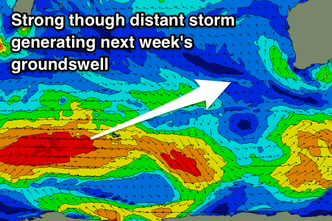 Wednesday's better long-range W/SW groundswell is being generated by the bulk of the storm, with a fetch of gale to severe-gale W/SW winds pushing east, breaking down once reaching the Heard Island region.
The groundswell is due to arrive overnight Tuesday and peak through Wednesday to a good though inconsistent 6ft on the exposed reefs in Margs (if not for the odd rare bigger one), 2ft in Mandurah and 1-2ft Perth.
Winds will remain great and offshore out of the E-E/NE on Tuesday, variable into the afternoon and then E/NE tending NE and then variable on Wednesday as another inland surface trough forms into a low and pushes offshore.
The low is expected to quickly move back inland and drift south-east, with winds a little dicey but most likely variable across the South West and NW further north.
Longer term a small new SW groundswell may be seen on Thursday but beyond this a flurry of mid-latitude frontal activity is expected as a strong node of the Long Wave Trough develops to our west.
This looks to bring onshore winds and large surf into the weekend and beyond, but more on this Monday. Have a great weekend!