Easing swells and winds to end the week, large W/SW swell for Sunday but onshore

Western Australia Surf Forecast by Craig Brokensha (issued Wednesday 6th June)
Best Days: Thursday morning Mandurah and Perth, early Friday Margs, Mandurah and Perth through the morning, Monday morning
Recap
Gale-force N'ly tending NW winds yesterday ahead of a strong W/SW change through the day, but no real quality surfing options.
This morning the swell has remained poor with fresh and gusty onshore winds.
Today’s Forecaster Notes are brought to you by Rip Curl
This week and weekend (Jun 7 - 10)
The severe low linked to our current poor conditions is stalling to our south, with a fetch of severe-gale S/SW winds being generated in our southern swell window.
The low will weaken this evening and start moving east out of our swell window, resulting in a drop in localised W/SW swell tomorrow with onshore W/SW tending SW winds across the South West.
Perth and Mandurah are likely to see variable winds and fun 2-3ft leftover sets, more to 6ft across the South West.
The fetch of S/SW gales will generate a moderate to large S/SW groundswell for Friday morning across the South West, with 6ft to possibly 8ft across magnets, with small 2ft+ waves in Mandurah and 2ft Perth.
 Winds for Friday morning are dicey, the north half of the Cape is likely to see variable if not local E/NE winds, onshore from the W to the south, with Mandurah and Perth offering light E winds.
It will be another case of checking the local winds observations around Margs to make a call on surfing Friday morning. In any case the afternoon will be poor with a freshening NW breeze.
This increasing NW airstream will be linked to a vigorous mid-latitude front approaching from the west, with it forming today west of Heard Island.
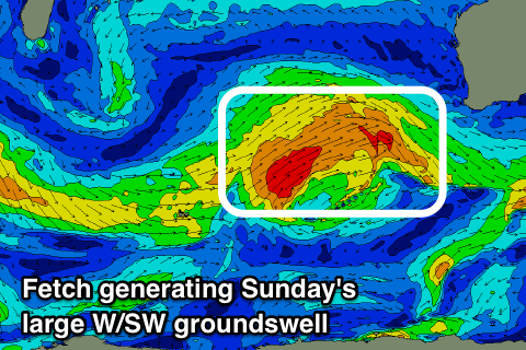
A great fetch of W/SW gales are being projected through our south-western swell window, moving more into our western swell window tomorrow and Friday.
The front will move in on us Saturday bringing strong NW winds that may reach the gale-force range into the afternoon, along with building levels of NW windswell.
The groundswell is due Sunday, peaking into the afternoon, mixed in with some local W/SW swell behind an overnight change.
The South West looks to build to 8-10ft but with gusty W/SW tending SW winds, with 3-4ft surf in Mandurah and 3ft waves in Perth.
Monday will hopefully see variable winds in the wake of the front and clean easing surf across all regions, down on Sunday afternoon's size.
Longer term it looks like a strong node of the Long Wave Trough will develop through the Indian Ocean, bringing winter calibre storms and swell from next weekend, with a fun large pulse before this next Wednesday/Thursday. More on this Friday.
Comments
Still cooking in Perth this arvo..