Good easing surf tomorrow, oversized and pumping Saturday

Western Australia Surf Forecast by Craig Brokensha (issued Wednesday 25th April)
Best Days: Thursday morning, later Friday protected spots, Saturday for experienced surfers, Sunday morning
Recap
Poor waves across the South West with small onshore surf, while Perth and Mandurah continued to see good surf with 2-3ft waves across both regions with morning offshores.
This morning we fell in between swells but conditions were good across all locations and we're now seeing some new SW groundswell building in the South West with sets to 4-5ft.
We should see the South West reach 6-8ft by late today and 2ft+ in Mandurah with 2ft sets in Perth but with sea breezes.
Today’s Forecaster Notes are brought to you by Rip Curl
This week and weekend (Apr 26 - 29)
This afternoon's first pulse of large SW groundswell is due to peak overnight, easing back from 6ft to possibly 8ft across the South West tomorrow morning, 2-3ft in Mandurah and 2ft in Perth.
Conditions are looking good with a light E/NE wind at dawn, tending NE through the morning and then NW-W/NW into the afternoon with an approaching front, linked to our large SW groundswell on Saturday.
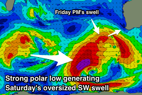
Currently a vigorous polar low is forming just east of Heard Island, with two seperate fetches developing.
 First a more northern and mid-latitude fetch of W/SW gales will be projected towards us today and tomorrow, weakening while clipping the state tomorrow evening.
This will produce a large W/SW groundswell that's expected to build through Friday and reach 6-8ft across late in the day across Margs, 2-3ft in Mandurah and 2ft+ in Perth. Winds look average though workable in protected spots as the swell kicks later with a S/SW tending S/SE breeze across the South West and morning SE winds further north, giving into afternoon sea breezes.
Moving into Saturday and we'll see an oversized long-period SW groundswell filling in, produced by stronger severe-gale to storm-force SW winds at the core of the polar low, projecting slightly north-east through tomorrow.
This swell is expected to fill in through the morning and peak during the middle of the day with large 10-12ft waves across Margs swell magnets, 3-4ft in Mandurah and 2-3ft in Perth.
It should be kept in mind the models are combining the W/SW swell energy from Friday with the new SW groundswell and over-forecasting the overall size of the swell at some spots Saturday.
A fresh E-E/NE wind will create clean conditions, easing off into the afternoon and tending variable creating an excellent surf day for experienced boardriders.
The swell will ease off steadily through Sunday with less favourable NE tending N/NE winds.
Early next week isn't too favourable as the swell continues to ease with average NW tending SW winds Monday and S/SE breezes Tuesday.
We should see some small to moderate sized mid-period W/SW swell Wednesday ahead of a possible better S/SW groundswell Thursday/Friday, but more on this next update.
Comments
Nice satellite grab from the storm generating Saturday's swell.
Promising report Craig - always good to see some activity.
Do you expect N/E winds for the offshore metro area for Saturday or more a S/E trend?
I'd say early E/SE tending E through the morning and then E/NE midday before going variable.
Craig will you doing another updated forecast today or has nothing changed since Wednesday?
I'm on the froth
Yep, but there's no real change.