Large SW swell building Friday, with a secondary pulse Saturday as winds improve

Western Australia Surf Forecast by Craig Brokensha (issued Wednesday 11th April)
Best Days: Early Friday Mandurah and Perth, protected spots later in the day, Saturday morning, Sunday morning, Monday in the South West, later next week
Recap
Our large SW groundswell provided solid sets across all locations and there were early favourable winds across the South West, good up around Mandurah as well but poor in Perth.
This morning was cleaner around Mandurah and Perth with straight offshore winds and few fun sets hanging in the mix. Margs was bumpy and average with a drop in swell.
Today’s Forecaster Notes are brought to you by Rip Curl
This week and weekend (Apr 12 - 15)
Tomorrow will be a lay day across all locations with a further drop in swell from today and fresh onshore W/SW tending SW winds, as the cold front linked to Friday's first increase in large SW groundswell clips the state.
Currently we're seeing a fetch of slowly weakening gale to severe-gale SW winds projecting towards us, with the front clipping us tomorrow, followed by a secondary embedded front on Friday.
 This along will generate a large increase in SW groundswell through Friday with exposed breaks in the South West expected to reach at least 8ft into the afternoon, and mostly likely 10ft on the sets late in the day.
Mandurah should build to 3ft into the afternoon, with Perth reaching 2-3ft, but conditions will be poor across the South West with a gusty S/SW breeze. Try protected spots for a wave. There's a good chance for early S/SE winds around Perth and Mandurah early Friday, though expect smaller waves compared to the afternoons size.
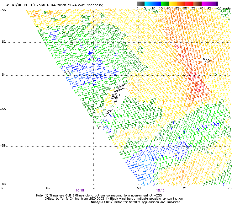
Our less consistent but more powerful long-period SW groundswell energy for Saturday is still on track, with satellite observations (right) confirming fetches of severe-gale to storm-force winds in our swell window west of and around the Heard Island region.
This swell should provide large powerful though inconsistent sets to 10ft Saturday morning (if not for the odd bigger cleanup bomb, with 3ft surf in Mandurah and 2-3ft waves in Perth.
Conditions will improve with great offshore E/SE winds around Perth and Mandurah, light SE across Margs before sea breezes kick in.
The swell is due to ease slowly through the day, down from 6ft to possibly 8ft Sunday morning across the South West, 2-3ft in Mandurah and 2ft+ range Perth.
Morning SE winds are expected across the South West again (likely tending E/SE for a period) before sea breezes kick in. Mandurah and Perth should see E/SE winds.
Next week onwards (Apr 16 onwards)
 We'll see the surf continuing to ease into early next week, with the storm linked to our possible S/SW groundswell for Tuesday forming a little too late and east of our swell window.
Conditions will be great Monday with an E/NE offshore across all locations, tending variable into the afternoon, with late weak sea breezes likely.
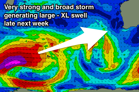
Mid-week a small-moderate W/SW groundswell is due off a less than favourably structured mid-latitude low, but of greater importance is a vigorous polar storm that's due to develop south of South Africa and project a significant fetch of severe-gale to storm-force W/SW winds through the south-west Indian Ocean, breaking down before getting closer to us.
At this stage this system would produce a very large long-period and powerful W/SW groundswell (bigger than the coming swell) for later Friday and Saturday with possible offshore winds. We'll have a closer look at this impressive storm on Friday though.