Clean fun surf across magnets, onshore from the weekend and large Tuesday

Western Australia Surf Forecast by Craig Brokensha (issued Wednesday 4th April)
Best Days: Margs swell magnets Thursday and Friday mornings, Perth and Mandurah Wednesday morning, protected spots in the South West
Recap
Good conditions yesterday with a fun reinforcing SW groundswell across the South West and morning offshores, tiny to the north.
This morning a new SW groundswell provided more size across all coasts, 4-6ft in the South West, 2ft in Mandurah and 1-2ft Perth, though conditions weren't as clean, but workable.
Today’s Forecaster Notes are brought to you by Rip Curl
This week and next (Apr 5 - 13)
Today's SW groundswell is expected to ease through tomorrow under much better E/SE offshore winds, with 4-5ft sets in the South West, 1-2ft in Mandurah, tiny to the north.
A new reinforcing SW groundswell is due into the afternoon, produced by a relatively weak polar front and we'll see this swell easing into Friday from 4ft on the sets in the South West with tiny waves to the north.
Winds look great again with a straight E'ly offshore (E/NE around Mandurah and Perth) ahead of sea breezes.
 Moving into the weekend and we're now unfortunately looking at onshore winds across all coasts as a weak surface trough moves in from the west bringing W/SW winds on Saturday and W/NW tending W/SW winds Sunday. There's the possibility of more variable winds Sunday morning but we'll review this Friday.
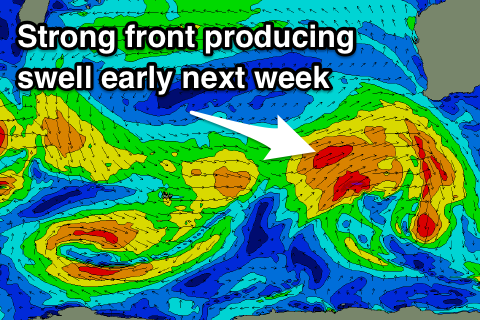
The weak surface trough will be the precursor to a much strong polar front projecting up and towards us under the influence of the strong node of the Long Wave Trough.
This system will be the first of a couple of stronger storms moving through the Indian Ocean, generating swell for early-mid next week and the following weekend.
Coming back to the first swell though, an initial fetch of strong W/SW winds will set in motion an active sea state for a secondary better fetch of gale to severe-gale SW winds to move over, projecting north-east towards us and across us Sunday evening/Monday.
We should see a large SW groundswell for Tuesday, with Monday offering a building windswell reaching a messy 6ft+ in the South West late, 2-3ft in Mandurah and 2ft Perth.
Tuesday will see larger messy surf to 8ft across the South West, 3ft in Mandurah and 2-3ft Perth but with strong W tending W/SW winds.
Lighter S'ly winds are due Wednesday as the swell eases across the South West, better and E/SE across Perth and Mandurah.
The next large groundswell due into next weekend will be produced by a vigorous but distant polar low forming west of Heard Island.
At this early stage we're looking at a fetch of severe-gale W/SW winds projected through our swell window as the low moves slowly east and then possibly projecting towards us. It's too early to put down a size on this swell but it's looking large. More on this Friday.