Easing surf, lots of activity from late week

Western Australia Surf Forecast by Craig Brokensha (issued Monday 20th March)
Best Days: Tuesday, dawn Wednesdat, later Friday protected spots, Saturday morning
Recap
Well what a weekend of surf! Saturday saw onshore winds and the beginnings of a building XL swell, reaching this range into the afternoon across the South West. Onshore winds limited the best waves to protected spots, while the outer bommies offered some monsters.
Sunday was the day to get out the big guns with offshore winds, easing 10-12ft surf and 3ft waves around Mandurah and Perth.
Today the swell was smaller but still great and around 4-6ft in the South West, with 2ft waves to the north under offshore winds.
This week and weekend (Mar 21 - 26)
Smaller surf is expected tomorrow as the weekend's XL SW groundswell continues to ease, but some background energy will keep Margs kicking around 3-4ft with 1-1.5ft waves further north.
A new pulse of S/SW groundswell from an intense polar low forming late in our swell window over the weekend should come in Wednesday morning offering good 4-5ft sets across magnets open to the southerly swell. Perth and Mandurah aren't due to see any real size at all off this low.
Easing surf is then expected into the afternoon, smaller Thursday.
Conditions are looking good again tomorrow, if not a tad windy with fresh and gusty E'ly winds for most of it, tending SE late across the South West as a small low drifts south down along the coast.
This low will then deepen a little while drifting south Wednesday, resulting in fresh to strong S/SE tending S/SW winds, and some possible small weak S/SW swell Thursday but with onshore S/SW winds (not worth worrying about).
The low should weaken Thursday evening allowing winds to tend back to the S-S/SE Friday.
From Friday we should see some fresh SW groundswell building across the state, bigger into Saturday.
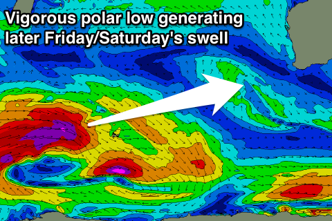 This swell event has already started to be generated by a vigorous polar low spawning south-east of South Africa, with a fetch of severe-gale to storm-force W'ly winds being projected through our far swell window.
The low will broaden while weakening slightly as it pushes east, breaking apart east of Heard Island and generating two pre-frontal W/NW fetches on the periphery of our south-western swell window.
What we can expect from this is some small SW groundswell Friday morning from the pre-frontal W/NW fetch, coming in at 3-4ft in the South West (0.5-1ft Perth) but following closely behind will be the long-period and larger SW swell.
We should see Margs kicking through the afternoon to a solid 6ft, possibly bigger near dark, with a peak Saturday morning to 6-8ft (if not for the odd bigger sneaker). Perth should see 2ft sets late, with 2ft to nearly 3ft sets Saturday.
Winds on Saturday morning look good at this stage with a light offshore E'ly but a vigorous low deepening significantly south-west of us (due to a strengthening node of the Long Wave Trough) looks to bring a W/NW change into the afternoon.
The models are still moving around regarding the structure and speed of this low, and this looks to be related to the possible formation of a tropical cyclone off our North West.
In any case it looks like we'll see a large to XL swell generated by this low, building through Sunday and peaking Monday with SW breezes.
Beyond this there's likely to be some follow up polar frontal activity through our southern swell window, but more on this and Sunday/Monday's swell in the next update Wednesday.
Comments
Peaking on Monday .
"In any case it looks like we'll see a large to XL swell generated by this low, building through Sunday and peaking Monday with SW breezes"