Possible windows of fun waves late week, lots of activity from the weekend

Victoria Forecast by Craig Brokensha (issued Monday 9th April)
Best Days: Desperate surfers east of Melbourne tomorrow, possibly Thursday morning, Friday morning both regions, Surf Coast Sunday onwards
Recap
Fun-ish waves across the Surf Coast Saturday morning with smaller surf than the previous days but clean conditions on both the beaches and reefs.
The Mornington Peninsula was the pick on Sunday with clean conditions and good sized sets to 4ft, easing through the day, while the Surf Coast continued to offer a few fun ones.
This morning we've back to small leftover but clean 2ft sets on the Surf Coast and bumpy average waves to the east.
Today’s Forecaster Notes are brought to you by Rip Curl
This week and weekend (Apr 10 - 15)
The coming couple of days aren't looking too flash with the swell continuing to fade under local offshore winds (try the Mornington Peninsula early for the odd 2ft'er), while come Wednesday the surf will be small to tiny under an unfavourable dawn W/NW tending SW breeze and S/SE into the afternoon.
Looking at the W'ly and W/SW swell energy due mid-late week and the frontal progression firing up towards WA isn't as ideal for our region as it was looking on Friday.
An initial fetch of W/SW gales then pushed a little too far north of our swell window, and during Wednesday we're hardly due to any size developing across both regions until late.
 The Surf Coast may see 2ft sets late with 3-4ft waves on the Mornington Peninsula but with that onshore S/SE wind.
A better W/SW groundswell energy is due to build through Thursday and fade through Friday produced by a better aligned but weaker fetch of strong W/SW winds under WA, and more polar strong to gale-force SW winds.
This will likely see the Surf Coast building to 3ft into the afternoon Thursday, easing from 2ft to occasionally 3ft Friday morning. The Mornington Peninsula should reach 4-5ft, easing from the 4ft range Friday.
Now, winds are still looking a bit tricky as a possible surface trough brings offshore NE winds Thursday morning as forecast by the European version, while the American GFS has lingering S/SE winds Thursday, better Friday with a light morning N/NW breeze in the morning (hopefully N/NE to the east).
With the divergence you'll have to check back here Wednesday for confirmation on the local winds.
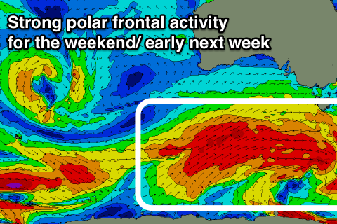
Moving into the weekend and a flurry of strong polar frontal activity firing up towards WA late week will make its way east towards us on the weekend and re-strengthen under the effects of a strengthening node of the Long Wave Trough.
We'll see an initial strengthening mid-latitude front followed by much broader and strong polar activity, generating back to back pulses of moderate to large groundswell.
At this stage it looks like we'll see a moderate sized plus mix of building W/SW groundswell and windswell Saturday as the first front pushes through, peaking Sunday morning, with better groundswell energy likely into the following week.
Winds through this period will be from the western quadrant, favouring the Surf Coast and other protected locations, but we'll nail down the specifics on swell wise and local winds once the models converge a little more Wednesday.