Good Surf Coast tomorrow, beaches early next week, then swell again late week

Victoria Forecast by Craig Brokensha (issued Friday 15th December)
Best Days: Surf Coast Saturday, beaches east of Melbourne Monday morning and early Tuesday, Surf Coast Thursday and Friday mornings
Recap
Tiny waves for the most part across the Surf Coast yesterday, with 1-2ft sets left at 13th Beach, though early light winds gave into increasing onshore breezes. The Mornington Peninsula was small and average.
This morning we've got light winds and clean conditions across the Surf Coast with a building swell that's now around 2ft, but will increase further during the day while strengthening in power. The Mornington Peninsula also offered light winds but conditions aren't looking too appealing with lots of lump and wobble.
We should see the new W/SW swell that's currently building reaching 3ft on the Surf Coast mid-late afternoon and 4-6ft on the Mornington Peninsula, though with afternoon sea breezes.
Today’s Forecaster Notes are brought to you by Rip Curl
This weekend and next week (Dec 16 – 22)
This afternoon's increase in W/SW swell was generated by a frontal system pushing under the country the last two days, and should hang in tomorrow morning at a similar 3ft on the sets across the Surf Coast and 4-6ft on the Mornington Peninsula.
A secondary front is sliding in from the west now, generating a pre-frontal fetch of strong W/NW winds. A reinforcing W/SW swell is due off this front later tomorrow and Sunday morning, keeping the surf up in that 3ft range at swell magnets on the Surf Coast and 4-6ft to the east.
Then behind this, one final burst of strong and favourably tracking SW tending W/SW winds should soften the easing trend into Sunday afternoon, with a more pronounced drop in swell visible Monday morning. Easing sets from 2ft+ are expected on the Surf Coast and the 4ft range on the Mornington Peninsula.
 Coming back to the local winds, and a light W/NW-NW breeze will create great conditions across the Surf Coast tomorrow morning before sea breezes kick in, while Sunday is still looking poor as a weak trough off the East Coast directs freshening E/SE tending SE winds into the coast.
An improvement in conditions should be seen across select beaches Monday morning with an E/NE-NE wind before SE sea breezes develop.
The swell will continue to fade through Tuesday owing to a deep and powerful low off the West Australian coast setting up a blocking pattern through our swell windows, and an early N'ly wind will favour the exposed beaches with small fading 2ft sets.
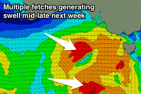
Now, of greater importance is the interaction of this cold core low off the WA coast with a warmer inland surface trough as they both drift south-east across the Bight and into the Southern Ocean.
We'll see these systems combine resulting in the re-intensification of the low directly south-west of us, with a flurry of strong to gale-force W/SW and SW winds projected through our swell windows during Tuesday and Wednesday.
This should generate moderate amounts of mid-period W/SW groundswell, building through Wednesday and peaking Thursday at this stage.
We're looking at surf to the 4ft range on the Surf Coast and 6ft+ on the Mornington Peninsula Thursday under a W/NW-W/SW airstream, favouring the Surf Coast.
Follow up activity is on the cards for the following weekend, but we'll have a closer look at this and the swell mid-late week on Monday. Have a great weekend!
Comments
That's a really nice hawk (I think) at the lookout in today's surf report pics. Well taken!