Good Surf Coast waves all week

Victoria Forecast by Craig Brokensha (issued Monday 11th September)
Best Days: Surf Coast Tuesday, Wednesday morning, Thursday, Friday
Recap
Lots of swell Saturday with a window of OK winds across the Surf Coast during the morning, while yesterday conditions were great all day with fun amounts of easing swell.
The swell has bottomed out into this morning leaving small clean waves at swell magnets across the South West and fun 2-3ft sets on the Mornington Peninsula.
This week and weekend (Sep 12 - 17)
Later today we should see some new W/SW groundswell filling in, but a much stronger and better swell is due tomorrow.
This swell was generated late last week and into Saturday by a strong but distant polar low south-west of WA.
The system weakened while slowly moving east closer towards us, so this should help keep the consistency of the swell reasonable.
 There's been no real change to the expected size across the region with the Surf Coast magnets due to reach an inconsistent 3-4ft tomorrow with 6ft sets on the Mornington Peninsula and winds look great. A light NW breeze should favour the Surf Coast all day, with the swell dropping back temporarily into Wednesday morning.
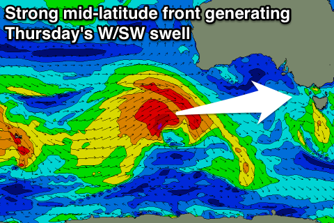
Gusty W/NW winds will continue to favour the Surf Coast during the morning, but a W/SW-W change is due through the day, associated with a mid-latitude front pushing in and across us.
This mid-latitude front is currently south-west of WA, with a great fetch of W'ly gales being generated through our western swell window.
This front will continue east, weakening a touch but maintaining a good fetch of strong W/SW winds through our western swell window, passing over us Wednesday.
A moderate to large sized W/SW groundswell is due off this system, building Thursday and peaking into the afternoon, but the front pushing into us Wednesday will generate moderate amounts of mid-period W/SW swell for the morning.
 The Surf Coast looks to be in the 3-5ft range most of the day, strongest into the afternoon, with 6ft to occasionally 8ft sets on the Mornington Peninsula.
Winds look like they'll be fresh to strong from the W/NW-W through most of the day, favouring the Surf Coast, while better NW winds are due Friday as the swell eases back from 3-4ft and 6ft range respectively.
Moving into the weekend, we'll see a relatively benign mid-latitude front deepening right off our door step on Friday and into Saturday with a tight fetch of severe-gale SW winds due to be generated in our swell window.
This is expected to produce some large stormy SW swell for Saturday though the size is a little uncertain with some model divergence. Winds are mostly looking poor and strong to gale-force from the W/SW tending S/SW, while we may see a ridge of high pressure moving in quickly Sunday, resulting in much better conditions. We'll look at this dynamic low again on Wednesday.