Great Surf Coast waves

Victoria Forecast by Craig Brokensha (issued Wednesday 6th September)
Best Days: Surf Coast Thursday, early Friday, early Saturday, Sunday, Tuesday onwards
Recap
Large clean but rawish Surf Coast waves yesterday, coming in around 6ft on the sets in the morning before building further towards 8ft on the sets into the afternoon with an increasing in SW groundswell. Winds remained favourable for protected spots all day, and today we've seen the more southerly S/SW swell filling in.
Cape Sorell has been hovering around a large 6-7m over the last 24 hours with a Max Wave Height recording of 13.6m last night.
This is translating to large 6-8ft waves across the Surf Coast reefs again with a moderate to fresh offshore wind.
We should see the surf remaining large most of today out of the S/SW as winds tend a little more W'ly across the state.
This week and weekend (Sep 7 - 10)
Today's large and powerful S/SW groundswell was generated by an amazing fetch of gale to severe-gale S/SW winds stretched out from the polar shelf, up into Bass Strait, but we've since seen this fetch weakening and moving off slowly to the east.
With this we'll see the S/SW groundswell easing later today, back further through tomorrow.
The Surf Coast reefs should still see 4-6ft waves tomorrow morning, with 6-8ft waves on the Mornington Peninsula.
A fresh W/NW breeze will create excellent conditions for the protected reefs ahead of a shift to the W again into the afternoon.
 Our new swell for Friday is still on track, but it's looking to arrive more from a SW direction and come in a touch smaller than forecast Wednesday.
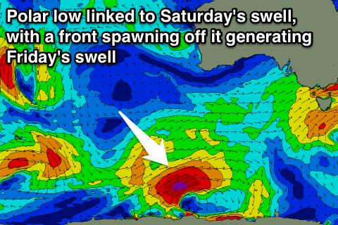
A strong polar low that's currently forming south-southwest of WA will generate a tight fetch of severe-gale W/SW winds before a cold front spawns off it, pushing up and into us tomorrow afternoon and evening. We'll see SW gales generated right on our doorstep, generating a close-range SW swell Friday.
The groundswell from the polar low is then expected to fill in Saturday as the close-range energy eases.
Size wise we should see the Surf Coast coming in at 4-5ft on Friday with 6-8ft sets on the Mornington Peninsula, easing back from a similar size Saturday morning, smaller into Sunday.
Winds on Friday will only be favourable for a short period around Torquay with early W'ly breezes, tending W/SW mid-morning.
Saturday looks to play out similar, but with SW winds into the afternoon, while Sunday will be much cleaner on the Surf Coast with a W/NW tending NW breeze.
Longer term, as touched on Monday we've got some fun W/SW groundswell due into next week, initially from a distant and strong polar low followed by more consistent energy into the end of the week. More on this Friday though.