Great Saturday morning and Monday morning

Victoria Forecast by Craig Brokensha (issued Friday 9th December)
Best Days: Surf Coast and protected spots east of Melbourne Saturday morning, Monday morning exposed beaches, early Tuesday east of Melbourne
Recap
Clean windy conditions yesterday morning but no swell, while a strong W'ly change kicked up a building windswell through the afternoon but with no quality.
Today a moderate sized mid-period SW swell has filled in with solid 3-4ft waves on the Surf Coast and 6ft surf on the Mornington Peninsula. The Torquay region wasn't too bad with raw semi-clean options in protected spots, while the rest of the coast was poor.
A peak in swell is due through today with a few bigger sets above 4ft on the Surf Coast and 6ft on the Mornington Peninsula but with poor SW winds.
This weekend (Dec 10 - 11)
The strong front responsible for today's swell is moving off to the east and with this we'll see the swell drop through tomorrow.
A new long-range and strong W/SW groundswell that impacted Western Australia yesterday is due to arrive later this afternoon and peak tomorrow morning across the state, easing later in the day and further Sunday.
Most locations should see inconsistent 3ft waves tomorrow morning on the Surf Coast, with 4ft sets at magnets early, easing through the day, while the Mornington Peninsula should see 5-6ft sets.
A morning W/NW-NW wind will create great conditions on the Surf Coast, and protected spots east of Melbourne, with onshore breezes developing late morning.
Sunday when the swell becomes smaller is a little dicey with a light to moderate SW tending S/SE breeze that may be light from the W early around Torquay.
Next week onwards (Dec 12 onwards)
 The SW swell due Monday has been downgraded a touch, with the pre-frontal and post-frontal fetch generating it now looking a bit weaker than forecast on Wednesday.
Still, the beaches will be really fun with clean conditions under a N/NE offshore and 3-4ft sets across the Mornington Peninsula and 2ft+ waves on the Surf Coast. Winds may tend N/NW on the Surf Coast through the morning if we're lucky.
Come Tuesday a straighter N'ly offshore is due but the surf will be small and fading from 1-2ft on the Surf Coast and 3ft across the Mornington Peninsula on the sets.
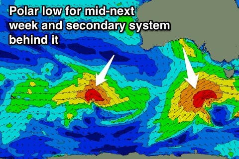
A late W'ly change is on the cards and this will be linked to a strengthening polar low to our south-west, starting to muscle in up towards us on Wednesday.
This could be the first of two strong systems, with an initial moderate sized S/SW groundswell on the cards for Thursday followed by a secondary pulse over the weekend although with onshore winds, but more on this Monday. Have a great weekend!
Comments
Yes yes. 4-5ft offys was always a mirage
At least we get two in a row off shore days with some waves except......... I have to work.
Looking nice this morning.. early lines at 13th Beach.
Still looking good a few minutes ago: