No shortage of quality waves for Southern NSW

Sydney, Hunter and Illawarra Surf Forecast by Ben Matson (issued Wednesday 6th December)
Best Days: Thurs/Fri AM: fun easing NE tending building E/NE swells with early light winds. Sat: mix of swells with early light winds. Sun/Mon: smaller, but clean early.
Recap: A solid combo of steady S’ly and building NE swell on Tuesday delivered 3-5ft surf across most beaches on Tuesday, before the S’ly swell eased today and the NE swell became dominant, maintaining 3-5ft surf across the Hunter to Sydney coast, reaching 4-6ft south from Sydney. Conditions were tricky on Tuesday with freshening S/SW winds, though we did see isolated patches of lighter SW winds. Today conditions have been very good overall with mainly light variable winds.
Today’s Forecaster Notes are brought to you by Rip Curl
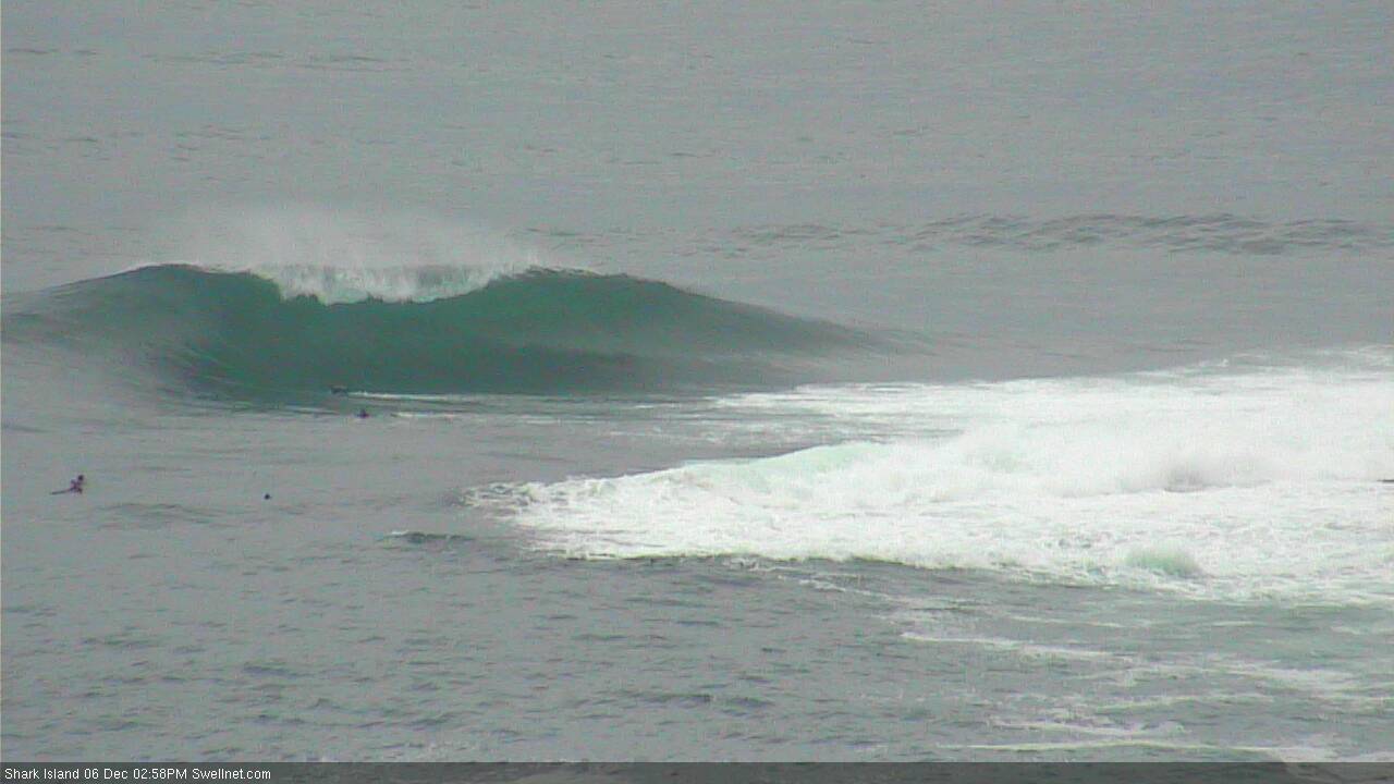
Decent peak at Shark Island this afternoon
This week (Dec 7th - 8th)
The great surf outlook for Southern NSW continues.
Our current NE swell will ease into Thursday, but a new long range E/NE swell will arrive into the afternoon and then peak through Friday, generated by a pair off E’ly dips north of New Zealand early in the week.
Wave heights should level out around 3ft+ across most NE facing beaches on Thursday morning, before rebuilding to 3-4ft+ either late in the day or (more likely) into Friday morning, with a broad spread of size across the entire region.
Unlike our current swell, which was more NE in direction and favoured the most size south of Sydney due to the fetch's position and alignment, this incoming E/NE swell was generated many thousand of kilometres from the mainland and should therefore provide a more uniform size distribution. The only downside with this event is that the sets will be much less consistent than what we have seen over the last few days.
Also, as I made mention in Monday's notes, I wouldn't overly surprised if a few locations delivered bigger waves than these estimates (owing to the initial development of the first of the E'ly dips, which was quite impressive although a long way form the mainland). An initial boost in swell period could produce a couple of hours of bigger bombs - most likely centred around Friday morning - but on the balance it feels like inconsistent 3-4ft+ surf is probably a good ballpark figure.
We may also see a minor south swell during the next few days, generated by a small low developing in eastern Bass Strait at the southern extremity of the existing broad coastal trough. However it’s not expected to line up very well so any swell we see will be small and confined to south swell magnets (the existing NE and new E/NE swells will be much more dominant).
The only concern through this period are the winds. An approaching front will freshen winds from the north from late morning Thursday onwards, though the early morning should see a lengthy period of light offshore winds (so, aim for a paddle before work).
The front will cross the coast during Friday morning, swinging winds around to the west though a S’ly change trailing behind will push across the region during the day, reaching the South Coast mid-morning, and the Sydney region early-mid afternoon. It won't be terribly strong but will be enough to bump things up.
As such, Friday morning is also your best window for a surf as we’ll see strong energy from the E/NE and an early light offshore breeze. There may also be a small level of N/NE windswell across the coast in the morning too, thanks to Thursday afternoon’s freshening trend.
So, the short version: aim for the morning session both days.
This weekend (Dec 9th - 10th)
Friday’s southerly change won’t have much fetch trailing behind, so the south swell possibilities into Saturday aren’t very high. South swell magnets should pick up 2ft to maybe 2-3ft of peaky S’ly swell in the morning, but elsewhere will be relying on leftover, easing E’ly swell from Friday. This small south swell will probably ease into the afternoon too.
The good news for weekend warriors is that we can expect solid, though inconsistent and easing E’ly swells to kick things off. Saturday morning should see inconsistent 3ft+ sets early morning, down to 2-3ft into the afternoon, and further to 2ft+ by Sunday afternoon. Again, expect long breaks between the sets.
A stronger Southern Ocean front modelled to push through the lower Tasman Sea on Saturday has had its alignment tweaked in the latest model guidance (more zonal, or west-to-east) which has reduced its surf potential. Early Sunday morning should see a small push into the 2ft+ range, with a second, bigger south swell likely arrive mid-late afternoon, offering 3ft+ sets at south swell magnets (upper end of this size range across the Hunter, smaller elsewhere), but confidence is weakening on this source so don’t make any plans around it - many beaches will dip out under such a poorly aligned storm track.
As for local conditions, a weak pressure gradient thanks to a broad high pressure system will create light variable winds and afternoon sea breezes. So once again, aim for the mornings for the best conditions.
Next week (Dec 11th onwards)
We’ve seen an abrupt change in the long range guidance since Monday, with the Southern Ocean storm track shunting out of our swell window.
Next week’s potential surf now looks like it’ll be reliant on the trades, which are expected to firm up north and north-east of New Zealand later this week. We won’t see a lot of size or strength from this pattern it should stop the open beaches from becoming tiny through the first half of next week. Monday should also see some small easing south swell from Sunday's energy.
Otherwise, there are no major swell sources on target for our near or mid-range swell windows. However, it's worth mentioning that the last few model runs have had a tropical cyclone near the southern Solomons at the end of each run for quite some time.
The latest guidance has started to strength this (modelled) system quite a bit, but what often happens in this scenarios is that we see it linger at the ‘end’ of the model run for quite some time, until it’s resolved and locked in with a firm formation timeline.
As such, we need to keep an eye on this system but I suspect it won’t be until this weekend or early next week where it starts to become a more of a sure bet for surf potential. And even then, SE Qld is a better target initially - we need lots of pieces of the puzzle to come together before Southern NSW is in the firing line from a potential tropical cyclone.
More on this in Friday’s update.
Comments
Lovin summer so far
Arms are already gone!!! Three surfs yesterday, and probably another two today...
Not the young man I once was, could do with an outboard motor.
Backing off a bit now or perhaps it’s the low tide not helping?