Building NE swell from Thursday onwards

Sydney, Hunter and Illawarra Surf Forecast by Ben Matson (issued Monday 13th November)
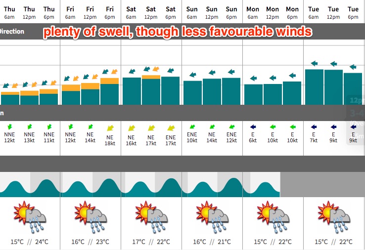
Best Days: Plenty of NE swell from Thursday onwards but winds will also be out of the NE until Sunday at least. A better E/NE swell is on the cards for Mon/Tues with lighter winds but confidence is not high at the moment.
Recap: Saturday delivered a great round of southerly swell in the 3-5ft range, with mainly light offshore winds and light afternoon sea breezes. Size dropped to 3ft on Sunday before easing further during the day; winds were light E’ly all day. Size eased further to 2ft today though there seems to be a small E’ly swell in the mix too. Winds have been light onshore once again.
This week (Nov 14th - 17th)
With no new swell sources due over the coming days, wave heights will remain very small across Sydney beaches through the middle of the week. Winds will slowly clock around to the E/NE then NE in the afternoons, bumping up the open beaches.
By Wednesday afternoon, the local NE flow should be sufficient enough to generate some small NE windswell for the coast, due on Thursday. We won’t see much size, and the concurrent NE breeze will provide bumpy conditions at open stretches, but NE facing beaches should pick up 2ft sets by Thursday afternoon, and maybe 2-3ft by Friday afternoon. Expect smaller surf at south facing beaches, and across the northern Hunter.
This weekend (Nov 18th - 19th)
The weekend outlook is a little tricky, with the models moving around considerably over the last few days regarding our upcoming E/NE swell event due Sunday onwards.
To begin with, Saturday should see a continuation of local NE windswell and moderate to fresh NE winds. Size should perk up a little more with 2-3ft+ sets across open NE facing beaches. It’s worth point out that we could also see an upwelling event around Saturday or Sunday because by this time we’ll be into our fourth or fifth consecutive day of coastal NE breezes. This could drop surf zone water temps by two or three degrees.
The new swell expected on Sunday has suffered a downgrade in the latest model guidance, though we are experiencing some see-sawing heights between each model run. At the moment we’re actually seeing divergence between models - which is unusual, considering the way they converged on this scenario late last week (I’ve been monitoring this progged event since the Friday prior, i.e. ten days ago) - and right now the entire leading edge could very well be shunted back until Monday.
If this occurs, then we’ll probably continue to see another day of short period NE swell on Sunday, though slightly smaller than Saturday due to a gradual weakening of the coastal trough and thus the local fetch. Let’s peg size around the 2-3ft mark and expect moderate NE winds to boot.
However, don’t be surprised if Wednesday’s updated forecast includes this new swell back into the matrix.
Next week (Nov 20th onwards)
So, this swell has been on the card for quite some time, and we’re still looking at quite a few more days until confidence beds down. But, it’s looking like Monday and Tuesday next week will see plenty off E/NE swell with light winds as the trough weakens along the coast, leaving us with a light variable flow.
For now, I will revise wave heights down to around 4ft across open beaches, though we’re still over a week away so some elasticity is still required at this early stage.
For what it’s worth, the middle of next week is expected to see a renewed strengthening Tasman high direct a broad NE flow across the western Tasman Sea, generating a lengthy period of NE swell about the NSW coast later next week and into the following weekend. So, there is plenty of surf in the longer term outlook still to negotiate.
More on that in Wednesday’s update.
Comments
Amazing footage off Ulladulla over the weekend. Fast forward to the last 10s..