Strong, windy end to the week, ahead of a fantastic weekend of SE groundswell

Sydney, Hunter and Illawarra Surf Forecast by Ben Matson (issued Monday 17th July)
Best Days: Thurs/Fri: large windy south swell. Biggest Friday, but with dicey winds. Large range in size between beaches too, depending on exposure. Sat/Sun: large clean SE groundswell with light offshores.
Recap: Saturday was tiny across Sydney beaches whilst Sunday saw a small new south swell deliver inconsistent 2ft sets in Sydney and 2-3ft sets across the Hunter. Today this small south swell eased right back and is pretty much unrideable this afternoon.
Next week (July 18th - 21st)
We have little to no new swell for the next two days.
A series of poorly aligned lows passing through the peripheries of our far window may provide minor pulses of south swell but no meaningful surf is expected at most beaches. Freshening offshore winds (W/NW tending W/SW) will groom the coast but it’s unlikely you’ll get wet, with a surfboard at least anyway.
A complex, deep low pressure system will cross the Tasmanian region on Tuesday, with associated cold fronts responsible for these freshening winds. They’ll eventually enter our south swell window on Wednesday morning but it’ll be an acute angle and I’m not confidence we’ll see much, if any size before the sun goes down.
That being said, a small increase in the forward speed of this storm, or an slightly anti-clockwise shift in the wind direction could see a possible late increase in south swell at exposed south swell magnets on Wednesday. I'll update in these notes if I come across any new data to suggest otherwise.
Overnight Wednesday we’ll start to see a rapid increase in S/SW swell from a SW tending S/SW fetch that’ll encompass the entire East Coast from SE of Tasmania to the Capricorn Coast in Central Queensland. That’s one heck of a spatial coverage - almost all of which will be aimed away from the coast (at least partially, anyway).
This system will display several individual fetches, and will correspondingly deliver a couple of strong short and mid range pulses of south swell for the rest of the week. To be honest, it’s hard to pick the precise trend of each for now so it’s probably best to blanket both Thursday and Friday with a size range, and expect some elasticity within each day as each swell ebbs and flows.
Thursday looks like it’ll be the smaller of the two, up to 4-6ft at south facing beaches though very steep in its southerly direction - so considerably smaller elsewhere (even more so than what we usually see under south swells) - protected southern corners may only be a foot or so. Winds will however be more out of the west as a secondary system approaches, so conditions should be clean. The Hunter should see slightly larger waves.
Friday should deliver a little more size (peaking around 5-6ft+ south facing beaches, bigger in the Hunter) thanks to a strong secondary fetch wrapping around the Tasman Low, but the swell direction should be a little more south. As such, protected locations should - by comparison to Thursday - see a little more size, but it'll still be quite small thanks to the acute southerly swell direction.
The main problems is that we’ll be at risk of S/SW gales enveloping the coast during the day and this will cause problems away from sheltered southern ends. Early morning has a chance for an early W/SW breeze though (quite gusty too).
So, it’ll be strong from the south but quite windy to finish the week, very typical for this time of the year.
This weekend (July 22nd - 23rd)
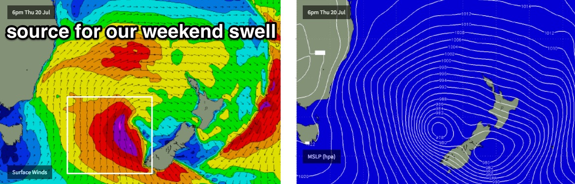
The low responsible for this swell will move towards New Zealand on Thursday and will reintensify into Friday, with gale to storm force S’ly winds generating a sideband SE swell for southern NSW. This is due to arrive on Saturday morning and should provide strong 6ft+ sets at exposed beaches, mainly those facing south. The swell may not be in the water at first light but should really start to kick in by mid morning, with a peak ezpected into the afternoon.
The great news is that winds are expected to ease rapidly and tend light W’ly as a high pressure system moves in from the west - so we’re looking at clean conditions everywhere.
Southern corners will be smaller but they should pick up a healthy percentage of size because of the more S/SE thru' SE swell direction. In fact, if this system comes off as modelled with wind speeds around 45kts+, we’ll see long swell periods (14-15 seconds) and this should create even larger surf at offshore reefs, and across the Hunter.
Let’s fine tune the specifics on Wednesday.
Sunday’s looking equally clean with light offshore winds, and a strong but slowly easing swell from 4-6ft at dawn, down to 3-4ft throughout the day.
So, at this stage it’s shaping up to be the best weekends of winter waves thus far this season. Let’s hope the models don’t move around too much.
Next week (July 24th onwards)
Nothing major showing up in the long range charts at this stage. But with a great weekend ahead, it’s hardly an issue right now.
Comments
Finally! Now make this part of the forecast for the payers!!!
Now ya talkin!
Fine weekend to be travelling away - but then again the Ulu's forecast ain't looking too shabby either :)
Hey Ben, how will this swell work for east coast Victoria? e.g the prom...?
West Coast of the prom won't see anything, but east from the Prom to the border should pick up some strong SE swell from this system. It's not perfectly positioned - a little too far north, and the fetch is even less favourably positioned for here compared to locations further north along the NSW Coast - but as an example, our model is estimating 6ft (double overhead) with light offshore winds for Mallacoota on Saturday.
https://www.swellnet.com/reports/australia/victoria/mallacoota/forecast
Thanks for the info mate,cheers!
Ooooooohhhhhh I know dozen or so river mouths that will be spitting pits!
Maybe I should come for a drive up your way for this swell hmmmmm.