Thursday is the pick of the forecast period in Sydney

Sydney, Hunter and Illawarra Surf Forecast by Ben Matson (issued Monday 5th June)
Best Days: Chance for a pocket of OK conditions and building swells early Wednesday. Thursday should see lighter SW winds and a building E'ly swell - this is currently the pick of the forecast period. Large but windy surf expected for the weekend.
Recap: The weekend saw slowly easing southerly swells though Saturday wasn’t much different in size from Friday with strong 4-6ft surf at south facing beaches. Wave heights eased into the afternoon and further to 3ft+ Sunday morning and 2-3ft this morning (smaller away from south swell magnets) and conditions have been generally clean with light winds.
Next week (Jun 6 - 9)
We have an active week on the synoptic charts, with generally dicey conditions though Thursday is offering a ray of opportunity.
With the current swell fading right out, we’ll kick off from a clean slate Tuesday morning. A gusty S/SW change is expected to push through around dawn, and will dominate much of the day however the initial fetch will be locally thin in latitudinal spread, and thus won’t be great for swell production. A small increase in short range energy is expected during the afternoon (2-3ft south facing beaches) but it’ll be quite wind affected.
A low will form in the western Tasman Sea and broaden a S/SE thru’ SE fetch adjacent the South Coast overnight Tuesday, which will further build surf size into Wednesday - but again with generally gusty winds from the southerly quadrant. There is a chance that we’ll see W/SW thru’ SW winds early morning from Sydney through to the Hunter region (in associated with the close proximity of the low) but this is an outside chance. And, surf quality probably won’t be very high - it’ll be smaller at this time (though building) and so it’s hard to have any confidence for a window of opportunity. It does certainly exist though.
Surf size will reach a peak into the afternoon, up to 4-6ft at south facing beaches, with a slightly broader spread of size owing to the S/SE the’ SE infeed around the bottom of the low, swinging the swell direction slightly more to the east of south.
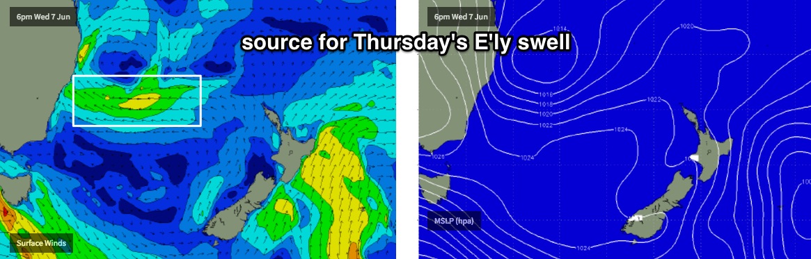
The low will then clear to the north, and surf size will abate from the S/SE into Thursday morning. However, we will concurrently see a building E'ly swell from a nice E'ly fetch expected to develop well east of Sydney - around the low's southern flank - late Wednesday onwards. This could provide anywhere between 3ft and maybe 5ft of peaky short range swell across the coast. As for local conditions, in general we can expect light winds from the SW, though there is a risk of a lingering southerly through the Hunter. Fingers crossed we see those early offshores.
Another cold front will enter the Tasman Sea late Thursday bringing a gusty overnight S/SW change to the region. This system doesn’t look quite as well aligned for our region but an increase is likely into Friday, perhaps some 3ft sets at south facing beaches with mainly SW winds (Thursday's E'ly swell will be a brief event, and will ease to 2-3ft by Friday).
There is a chance for an upgrade from Friday's developing S'ly fetch but at the moment the models are suggesting the strongest part of this next system will develop later Friday and thus provide a large swell increase for Saturday.
I’ll have more on that in Friday’s notes.
This weekend (Jun 10 - 11)
A strong southerly change pushing through the Tasman during Friday may result in the formation of a Tasman Low, but even if that doesn’t happen we’ve got a large S’ly swell for the weekend. Very strong, broad southerly winds extending north from Tasmanian latitudes will generate plenty of size and stregnth for our region. However, winds look dicey - mainly fresh and gusty from the south. Size could easily be north of 6ft+ so let’s see how the models are handling the situation on Wednesday.
This swell event will likely peak on Saturday, so Sunday’s looking at easing winds and swells from the southerly quadrant.
Next week (Jun 12 onwards)
Nothing major on the charts at this stage. The models have the weekend’s Tasman Low (if it forms) lingering in a weakened state to the north of our swell window, which would maintain moderate but easing SE tending E’ly swells into Monday but other than that there’s nothing to pin down specifically for the long term right now.