Lots of south swell ahead, but tricky winds

Sydney, Hunter and Illawarra Surf Forecast by Ben Matson (issued Friday 4th September)
Best Days: Sat: early offshores and a peaky south swell. Mon/Tues: fun S/SE groundswell and good winds.
Recap: Thursday panned out pretty much as expected. A combination of easing S’ly groundswell, new short range NE windswell and a mid-period E/SE groundswell all worked together to produce excellent 3ft+ waves across the Sydney and Hunter coasts under a freshening offshore breeze. Bigger surf was reported on the South Coast, because the core fetch was aimed a little better towards this region. Today we’ve seen building short range S’ly swell under a moderate to fresh southerly airstream, with sets in the 4-5ft range at south facing beaches and smaller surf elsewhere. Winds were SW (even W/SW!) for a brief period early morning across some locations but in general the waves have been pretty ordinary.
This weekend (Sep 5 - 6)
Today’s south swell will be well and truly on the way out by Saturday morning.
However, we’ve got a small new south swell expected to build across the region, generated by a modest front that tracked into the lower Tasman Sea on Thursday. This should keep south facing beaches in the 2-3ft+ range for much of the day, perhaps a little slow at times but otherwise fun. Keep in mind that beaches not open to the south will be considerably smaller due to the swell direction, but the Hunter should see a few bigger bombs.
Winds are expected to be offshore through the morning thanks to a building ridge of high pressure as the Tasman Low (responsible for today’s swell) pushes eastwards. However a weak front exiting eastern Bass Strait tonight will sweep along the Southern NSW coast during the day, delivering a S’ly tending S/SE change through the afternoon (into the South Coast around lunch, and Sydney mid-afternoon). So, surf early for the best waves.
In Wednesday’s notes, I mentioned that the merger of a polar front and a mid-latitude low S/SE of Tasmania on Friday would kick up a slightly bigger swell for Sunday. The good news is that this swell has been upgraded a little; the bad news is that it’s also been pushed back until Monday.
However, a small unrelated long range S’ly groundswell (of polar origins south of the continent) is showing up on the charts but this will probably just mix in with the leftovers from Saturday’s southerly groundswell to offer occasional 2-3ft sets at south facing beaches. Unfortunately, conditions aren’t looking too flash as a building ridge across the coast will drive moderate E’ly winds across most locations. There’s an outside chance for a period of light variable winds at dawn but I wouldn’t hold your breath.
In short: Saturday morning is the pick of the weekend, at south facing beaches.
Next week (Sep 7 onwards)
The new S/SE swell for Monday looks really good, although you’ll initially have to find a beach that enjoys northerly winds. Interestingly, the swell models aren’t really picking up this swell very well - but I’m expecting most south facing beaches to see inconsistent sets in the 3ft+ range, with bigger 4ft+ bombs at reliable south swell magnets and across the Hunter. Beaches not open to the south will be smaller, and the surf will be quite inconsistent at times. There's also a chance for a minor NE windswell at NE facing beaches too.
The source of this swell is a series of polar fronts tracking N/NE through the south-eastern corner of the Lower Tasman Sea from today through into Sunday. Remember those excellent, unusual S/SE swells we had a few months back? The broad synoptic flow doesn’t look too dissimilar to that pattern except core winds are a little weaker and the fetch is slightly off-axis.
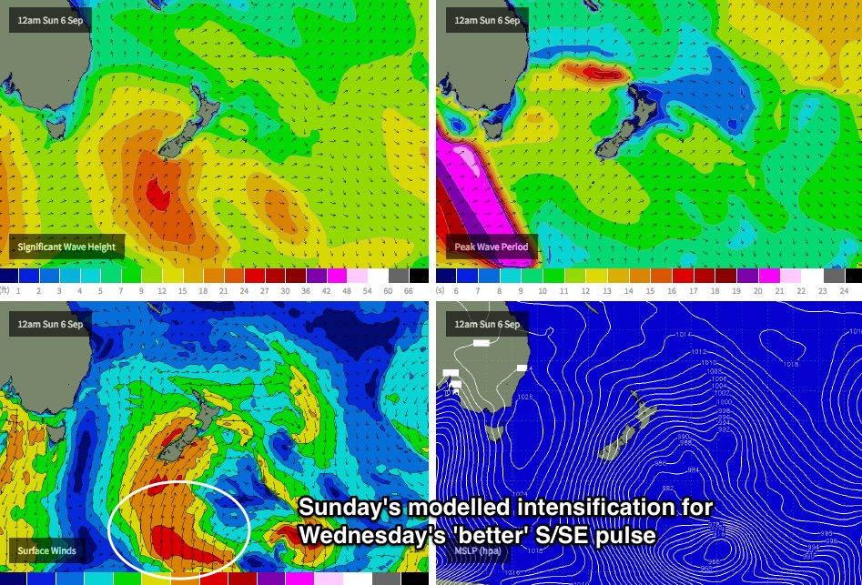
The extended duration of this storm track means that we should see intermittent energy holding through Tuesday and even Wednesday; in fact Wednesday’s pulse could end up being the pick of the series with a little more strength and size, owing to the storm track’s peak intensity south of New Zealand on Sunday (see chart below).
The key to finding good waves throughout this period will be to dial into the local winds. And the outlook is tricky with a front/low combo expected to cross the SE corner of the country on Monday, swinging a fresh morning northerly breeze around the west - so although the early session may be wind affected at some exposed beaches, it should imporove rapidly through the middle to latter part of the day (at this stage, pencil in an arvo session - I'll update in the comments below over the weekend if the models evolve).
Freshening SW winds are then expected on Tuesday as a new cut-off low develops just off the Tasmanian coast, and at some point (either later Tuesday or early Wednesday) we’ll see the low track NE, almost parallel to the Southern NSW coastline, strengthening S/SW winds along the coastal margin and building a large short range S’ly swell with set waves in the 5-6ft+ range at south facing beaches. So the mid-week trend looks windy and sizeable from the south (again!).
As such, if you want to capitalise on the aforementioned S/SE groundswell, it looks like Monday and early Tuesday will be your best windows. And unfortunately, the suggested better pulse of S/SE swell for Wednesday will probably be overshadowed by the large short range S’ly swell and accompanying gusty S/SW winds. Let’s wait and see how Monday’s model guidance is stacking up.
Otherwise, the longer term beyond Wednesday suggests easing S’ly swell through the second half of the week ahead of some new moderate southerly groundswell next weekend, originating from an active frontal progression in the Southern Ocean mid-week.
Have a great weekend, see you Monday!
Comments
Thanks again Ben, your forecast is always my first point of call before i study the maps for myself...learnt so much from you this year!!!