Average finish to the week, but looking good next week

Sydney, Hunter and Illawarra Surf Forecast by Ben Matson (issued Wednesday 24th September)
Best Days: Thurs AM: small peaky NE windswell, best around lunchtime.
Recap: Monday’s south swell eased to 2-3ft early Tuesday as expected, but managed to hold its size all day (which was unexpected). Early light winds gave way to freshening nor’easters in the afternoon. Very small leftovers this morning have offered meagre surfing options across the southern NSW coast today, and freshening NE winds this afternoon are slowly generating a new windswell.
This week (Sep 25-26)
A rather lacklustre finish to the working week. Today’s freshening NE winds will strengthen a little more overnight, whipping up a small windswell for Thursday morning but it’s not expected to be very high quality.
Local winds will be the key to success tomorrow. It looks like the early session will see a rapidly abating N’ly tending NW airstream, ahead of a moderate W’ly developing mid-late morning, holding through the early afternoon before a gusty S’ly change arrives across the Sydney region late afternoon (reaching the South Coast much earlier).
As such, the early session will probably see the most size but there’ll be some wobble on top. NE facing beaches should manage set waves between 2ft and maybe 3ft (smaller at south facing beaches, and in the northern Hunter) but conversely the South Coast may pick up a little more size through the afternoon.
The best surf throughout Sydney will probably be around the middle of the day, so keep an eye on the surf cams (best option: Manly) to monitor conditions.
Also in the water on Thursday will be a small, very inconsistent pulse of long range S’ly swell, generated by an intense polar low that tracked below the continent on Sunday. However there won’t be much more than a stray 1ft to perhaps 2ft set from this source. The leading edge of this swell has already been detected at the Eden buoy (Tp 16s at 2pm today) but is really only worth noting for curiosity purposes.
Anyway, the latest computer model output has strengthened Thursday’s southerly change, and so consequently has upgraded size expectations for Friday.
But before you get excited, this upgrade in size also comes with an increase in the strength of the accompanying southerly wind.
So, although south facing beaches will see the biggest waves (3-4ft+), they’ll be very bumpy. A few select regions - probably just the Northern Beaches - may see a brief window of SW winds but it’s unlikely to occur at many other places.
Therefore you’ll have to aim for a beach not open to the south, in order to secure a compromise between size and quality. Expect very small surf at protected locations due to the swell direction and period (and relatively small size). However the Hunter will probably see bigger waves, probably 4-5ft and very bumpy.
This weekend (Sep 27-28)
There’s a couple of sources of swell on the cards for the weekend but overall it’s a bit of a mixed bag. A weak secondary fetch trailing Thursday’s southerly change (later on Friday) will maintain a modest short range south swell for Saturday (3ft south facing beaches, smaller elsewhere but bigger in the Hunter) - but local winds will remain moderate out of the south as well. We should see early pockets of W/SW winds but you'll have to get in quick for the best conditions.
As detailed on Monday, a small front slipping into the southern Tasman Sea on Friday will generate some small sideband southerly energy for late Saturday and (more likely) Sunday, but only at south facing beaches and just a couple of inconsistent feet. The Hunter may see a few bigger waves but overall it's not worth too much excitement. Conditions will be much cleaner in the morning though, with light NW winds tending fresh NE in the afternoon.
Long term (Sep 29 onwards)
We have a couple of interesting swell sources on the radar for next week.
First up: Sunday’s late freshening NE wind may whip up a local quality windswell for Monday, probably just a couple of feet in Sydney but potentially another foot or two bigger on the South Coast.
Elsewhere, and just backtracking for a moment, Thursday’s southerly change is expected to form a low pressure system in the central Tasman Sea on Friday, before it moves towards New Zealand on Saturday.
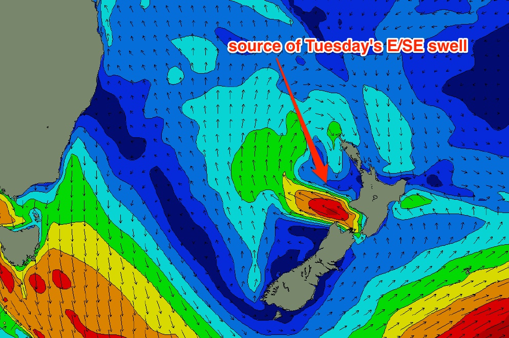
During Sunday, a new E’ly fetch is expected to develop within western Cook Strait (the body of water separating New Zealand’s North and South Islands - see chart below) and this is expected to generate a small and inconsistent but well defined E’ly swell for the region, probably arriving sometime around Tuesday with occasional 2-3ft sets at open beaches. I’ll update this in more detail on Friday once the outlook becomes a little more clearer and confident.
We’re also looking at a reasonably strong front through the lower Tasman Sea later Tuesday, which is expected to kick up a strong south swell for Wednesday. The models have been a little skewy on this over the last few days so I don’t feel comfortable pinning down wave heights right now, but at this stage it could generate a reasonable amount of size and energy, albeit windy on top.
And finally, a tropical low is modelled to form near New Caledonia over the weekend, before drifting south-east and merging (somewhat) with the remnants of the weekend’s central Tasman low. This is expected to form a broad new sub tropical low north of New Zealand on Monday which has good potential for a decent E/NE groundswell arriving sometime around Thursday.
However the tricky part of the long term equation is where the low will track - some model guidance has it slipping quickly south, in which case New Zealand’s North Island would shadow swell prospects for southern NSW. Right now it looks like being worthy of around 2-3ft of inconsistent long period E/NE swell but I’ll evaluate the model data more closely in Friday’s update.
Comments
as with another recent windswell which cleaned up after a change in wind direction, todays swell seemed to get better and more groundswell like (ie period increases, more sets and not so much in between) in the hour or so of glassy conditions before the southerly hit. Do the back of these systems create some sort of swell, or is it just the NE windswell cleaned up?