Lots more swell to come

Southern Tasmanian Surf Forecast by Craig Brokensha (issued Friday April 12th)
Best Days: Today, tomorrow morning, Sunday, Monday morning, Tuesday, Wednesday
Features of the Forecast (tl;dr)
- Moderate + sized, reinforcing S/SW swell for today with NW-N/NW tending W/NW winds
- Easing surf tomorrow AM with N/NW-NW tending S/SE winds
- Moderate sized S/SW swell for later tomorrow, peaking Sun AM with N/NW tending variable winds
- Easing swell Mon with W/NW tending fresher W/SW-SW winds
- Moderate + sized SW swell later Mon, peaking Tue with W/SW tending SW winds (likely W/NW early)
- Easing swell Wed with N/NW tending NE winds
Recap
Wednesday afternoon's strong pulse of groundswell eased back into yesterday morning, coming in more around 4ft across Clifton with lumpy, wind affected conditions.
This morning the swell was back to 3ft+ with morning offshore winds, but a reinforcing pulse of S/SW swell is now showing strongly across Clifton.

New swell sighted this afternoon (note old mate about to cop it on the head - right)
This weekend and next week (Apr 13 - 19)
Today's reinforcing pulse of S/SW swell which has boosted Clifton back to 3-4ft is due to ease into tomorrow morning, though still come in at 3ft.
This drop will be temporary with a good pulse of new mid-period S/SW swell due into the afternoon, peaking Sunday morning.
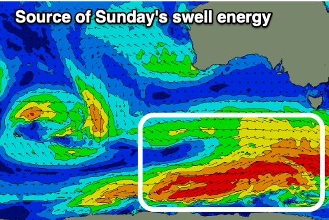
The source is healthy but patchy fetches of strong to gale-force W/SW winds currently on the polar shelf, with a kick back to 3-4ft expected later Saturday, easing from a similar size Sunday morning.
Monday looks smaller and back to 2-3ft temporarily before the next pulse of swell arrives into the afternoon.
Coming back to the local winds though and a moderate NW-N/NW offshore will give into weak sea breezes tomorrow, N/NW tending variable Sunday.
Monday will then see N/NW winds, tending W/SW-SW during the day and strengthening as the next swell generating system moves in.
That being a broad, slow moving polar low firing up under the country on the weekend.

We'll see a great fetch of gale-force W/SW winds projecting through our western and then south-western swell windows, producing a moderate + sized pulse of SW swell for later Monday but more so Tuesday.
We're looking at strong 4ft sets across Clifton on Tuesday with W/SW tending SW winds, but there's a good chance of early W/NW winds. We'll confirm this Monday.
Otherwise, Wednesday looks great with a NW offshore, tending NE into the afternoon along with easing 3ft sets.
The longer term is a bit divergent for now but there looks to be a few small swell sources on the cards. Check back Monday for the latest. Have a great weekend!
Comments
Missing these updates! Any reason for the week long lull?
Sorry mate, Craig's away - I'll have an update this arvo.