Great run of surf for the points from Thursday onwards

South-east Queensland and Northern NSW Surf Forecast by Ben Matson (issued Monday 8th October)
Best Days: Tues: small peaky beachies early. Thurs: building surf across the outer points, though windy. Fri/Sat/Sun: great waves across the points, though windy.
Recap: So, how was your weekend? The easterly swell pumped both days, and was noticeably strong if a little inconsistent, pushing 3-4ft through Saturday afternoon and Sunday, easing to 2-3ft today with a lot less frequency. Light variable winds delivered clean conditions on Saturday, and freshening southerlies on Sunday provided great options across the outer points. Today’s been a mixed bag with early light offshores ahead of afternoon sea breezes and some ripping thunderstorms across many parts of Far Northern NSW and SE Qld over the last few hours.
This week (Oct 9 - 12)
Today’s Forecaster Notes are brought to you by Rip Curl
Let me begin today’s notes by pointing out that around this time of year, there’s usually a lot of groaning and moaning about the lack of swell and persistent northerly winds. We’ve had a pretty good run, eh? Next time someone complains about out-of-season northerlies in April, I’ll remind them about this out-of-season run of easterly swell and southerly wind.
Anyway, we’ve got an excellent forecast period ahead. Tuesday looks a little average with freshening northerly winds and slowly easing E’ly swells from today, but there’ll be a pocket of morning light nor’westers about many beaches.
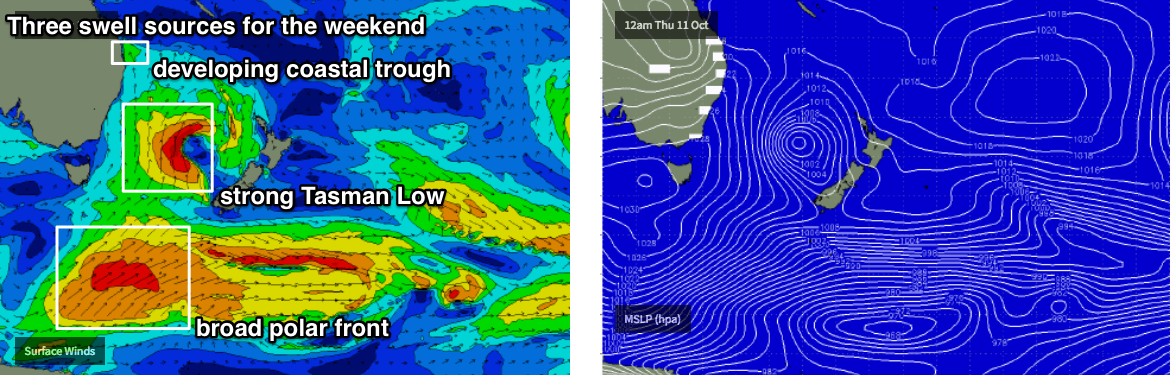
On Wednesday, an advancing polar front will merge with an eastward tracking upper and surface trough, forming a deep Tasman Low that’ll remain slow moving for a couple of days. It’ll drive a strong southerly change across Northern NSW during the day, though it’s doubtful we’ll see any appreciable surf in its wake to begin with. The best you can hope for is a period of slack winds ahead of the change, with small residual E’ly swells providing peaky waves to open beaches.
At this stage the S’ly is expected into Port Mac mid-morning, Yamba mid-afternoon before reaching the border just after dinnertime. Northerly winds are likely to persist across SE Qld on Wednesday as the change approaches though early morning should see a NW flow. Keep your expectations pegged appropriately low.
The model guidance shifted its predictions of the Tasman Low considerably over the weekend - first majorly upgrading Friday’s already-large estimate (from 10ft to about 12-15ft in Southern NSW!) but it’s subsequently pulled back predictions over the last day or so, mainly due to a slight eastward relocation of the low, and a tweak of the primary fetch out Southern NSW’s swell window.
However, this is actually a bonus for our region as the low’s likely new position off the West Coast of New Zealand will be very well positioned for Northern NSW, and thanks to its slow moving nature, will also be very beneficial for SE Qld.
So, Thursday will see rapidly increasing surf across the region though it’ll be accompanied by fresh to strong S/SE winds. They’ll tend SE into Friday as a trough intensifies off the Capricorn coast - though too far north of our SE Qld swell window to provide any major new swell - however, the groundswell will concurrently strengthen as longer period S/SE energy makes landfall from the actual Tasman Low: most of Thursday morning’s increase will be short range energy in the lee of Wednesday’s change; the stronger energy from the low will arrive from later Thursday onwards and peak into Friday.
How big? We need to keep in mind that strong S/SE winds will dictate our surfing opportunities, it’s worth pointing out that Thursday morning will likely display the largest variation in swell strength and size between exposed beaches and sheltered locations. So, south of the border, we’re likely to see south facing beaches pushing 5-6ft early, building to 6-8ft into the afternoon with the new energy.
Sheltered locations will be much smaller but we’ll see the size ratio tighten up a little into the afternoon, and further into Friday (i.e. bigger proportional surf size at southern ends on Fri, compared to Thurs AM).
But, the SE Qld points are really the draw card under this synoptic setup. Early Thursday should see 2-3ft sets at the outer points, building through the afternoon towards 3-4ft and bigger waves are likely through Friday approaching 3-5ft (exposed northern ends will be bigger but very wind affected). Sheltered inner points will see smaller surf though they’ll also pick up some small short range SE swell from the trough up north, into Friday.
So, leave your run until late Thursday or Friday as this is when we’re expecting the most size and the best conditions for the points.
This weekend (Oct 13 - 14)
This lovely big Tasman Low won’t be ideally aimed in the Tasman Sea, but it will be very slow moving and this will lend a lot of potential to our weekend forecast, thanks to a reintensifation around Thursday as a passing polar front gives it a nudge.
All weekend will see small underlying long period S’ly groundswell (from the related polar low) but we’ll see more size from sideband SE swell, that should manage 6-8ft sets across some exposed parts of Northern NSW at some point on Saturday and maybe even Sunday.
Across SE Qld, this should manage anywhere from 3ft to 5ft at reliable outer SE Qld, points, though it’ll be much smaller running through the sheltered inner points. Exposed northern ends will see larger waves.
Current model guidance (which should be taken with a grain of salt) actually has a couple of individual intensification periods - and thus two seperate pulses - so it’s hard to pin down the exact timing and size confidence, but I’d be leaning towards Saturday seeing the most size at this stage, with an easing through Sunday.
The main problem we have is that a new ridge is expected to build across the coast, deriving moderate easterlies into all regions. There’s a chance for brief, isolated periods of lighter winds but on the balance it’s looking like sheltered locations will see the only clean conditions.
Next week (Oct 15 onwards)
Enjoying this troughy patten? Looks like there’s more to come, with Sunday afternoon’s E’ly infeed expected to bring about another coastal trough and some short range E/NE swell for Monday, that’ll likely persist for a few days in and around the 3ft range with some assistance from a broadening ridge through the Northern Tasman Sea.
Winds may be a little suss - models suggest we’ll see anywhere from the E to the N/NE for seven days from next Monday until Sunday (or, nine if you kick it off from this Saturday), but hey! It’s an active period on the synoptics, and there’ll be waves - that's all that counts.
Comments
The weather patterns are really all over the place aren't they. Will take this forecast in October any time.
Might see some shortboarders return to Alex for the first time in forever.
Sorry, is it Oct or March?
The Autumn we never had, in Spring. It's cuckoo clock crazy but who could complain.
meanwhile the flathead gear gathers cobwebs.
Why ?
Aren’t you hitting the rivers at the time of year for flatties ?
I was in Indo for a couple of weeks and there's been waves, good waves, every day since I've been back.
pinned a nice keeper today though.
Best possible forecast for this time of year hope we have an active summer...
Thanks Ben, love how active the ocean is right now especially with the amount of E trade swell we have had, it really spreads out the crowds.
@Ben, do you know if there is an issue with this report and the email alerts for subscribers? I used to have this email each Mon/Wed/Fri but the email no longer comes through. No settings have changed on my side and I can see i am still subscribed to this report in account settings. Love hearing the email beep at around 5pm on those evenings to see whats in store for the next few days
My emails just started going to junk mail the last cpl weeks for some reason.
Our email provider (Mailchimp) has been having problems for the last week or so, and it's been a nightmare to sort out. We're working on it though (we're still sending out the emails, they're just not being received).
Yep last week has been the autumn we never had, and it's still kicking!
I recall last spring being pretty good. It was so good to get days of thick waves and peaks to your self. Like the trough set ups
Local winds look woeful later into the weekend and Monday based on latest forecasts.
Yeah been some big changes in the model output in the last 24 hours. Gonna leave it another day until I firm up my thoughts.
Seen it swing like a pendulum many times before.
Models are all over the place for later in the weekend and early next week. EC looks insanely Autumish!!