Minor weekend ahead; small E'ly swell Mon/Tues, then a complex ECL mid-late week onwards

South-east Queensland and Northern NSW Surf Forecast by Ben Matson (issued Friday 2nd March)
Best Days: Sat: get in early before the S'ly swell fades completely and the N'ly winds pick up. Tues: fun though small and very inconsisent E'ly swell with early offshores. Wed onwards: building S/SE swell from an ECL further south, though size may be limited to southern locations. Better prospects for SE Qld later next week onwards.
Recap: Thursday morning delivered great waves across most open beaches, around 3-5ft across Northern NSW and 2-3ft across northern ends of SE Qld with early NW winds tending NE ahead of a S’ly change. Size eased today and winds have abated, there’s been pockets of good surf out of the border, but SE Qld hasn’t seen enough size to be worthwhile.
Today’s Forecaster Notes are brought to you by Rip Curl
This weekend (Mar 3 - 4)
Wave heights will slowly ease all weekend, and with winds out of the north your best options will be south of the border at exposed south swell magnets. SE Qld will remain very small both days. The afternoons should see bumpy conditions with freshening NE breezes; mornings will be best under a more N/NW flow, light in strength.
There's really not much more to the weekend outlook than that - a small low off the SW tip of New Zealand today will generate a small flush of S/SE for Sunday afternoon (probably just the Mid North Coast) that won’t so much provide an increase in size, as arrest the easing trend.
Make sure you’ve got an appropriate high volume board, as there won’t be a lot of push in the surf over the next few days.
Next week (Mar 5 onwards)
In Wednesday’s notes I mentioned a small E’ly groundswell due early next week, from a low north of New Zealand later this week.
It’s still expected to show up, with extremely inconsistent 2-3ft sets at swell magnets in Northern NSW, slightly smaller across SE Qld through Monday afternoon and Tuesday, though freshening northerlies on Monday will create a few problems south of Ballina. With some luck winds will remain light north from Byron through SE Qld.
Tuesday morning is probably a better choice as we’ll see the most size - though still extremely inconsistent - and winds are likely to veer to the NW as a significant weather system develops to our south-east.
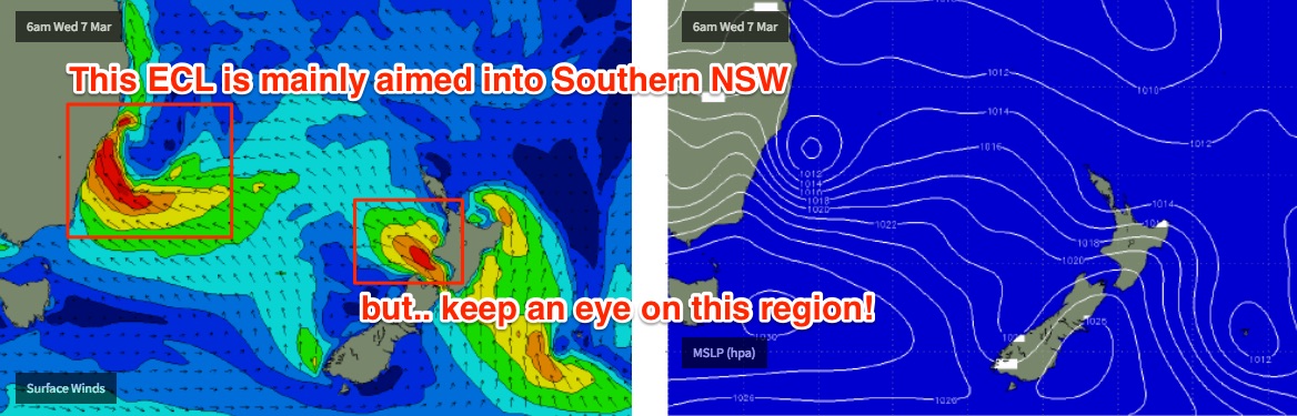
And, this system looks being quite a major event, for Southern NSW at least. A southerly change pushing up the Southern NSW cost on Sunday will be associated with a surface trough, which is expected to stall just below the Mid North Coast on Sunday, and a Tasman Low is expected to then slowly develop in the central/southern Tasman Sea from Monday onwards.
This system looks very interesting as it appears as though it’ll retrograde to the west as it strengthens, bringing strong onshore winds, very large surf and plenty of rain to Southern NSW - possibly as an East Coast Low (yes, it may end up ticking the correct classification boxes).
Initially, it’ll be poorly aligned for SE Qld, and only marginally aligned for Far Northern NSW. As you track to the south, size prospects increase - and with 8ft+ or more possible across the Southern NSW coast, there’ll be more than enough energy spreading northward to allow for some decent sized swells across the Mid North Coast. For now, sets in the 4-6ft+ range are likely at exposed beaches south from Port Mac or maybe Coffs Harbour through the middle of the week, though we'll need to refine this over the coming days.
However, local winds are tricky. A fresh southerly flow up the coast to begin with will probably veer offshore as the low tightens and draws closer to the coast (through Wed/Thurs, as the swell reaches a peak). This could mean potentially offshore winds for Northern NSW but its too early to have any real confidence.
Right now, swell prospects look grim for SE Qld early next/mid week from this system, though the latter part of the week and next weekend should bear more fruit as the tail end of this event spawns more favourably aligned fetches in the Tasman Sea.
Anyway, it’s an active period ahead - I’ll have a much more comprehensive update this system on Monday.
Have a great weekend!
Comments
*YAWN* .....Zzzzzzzzzzzzzzz
Gotta hate when the full forecast shows the wind and swell coming from the same direction the entire week. Ah well. Back to work to catch up