Easing S'ly swell tomorrow, kicking again Sunday afternoon, peaking Monday morning

South-east Queensland and Northern NSW Surf Forecast by Craig Brokensha (issued Friday 15th September)
Best Days: South magnets Saturday morning, Monday morning open beaches, Tuesday morning south magnets
Recap
Good amounts of N/NE swell across most regions yesterday morning, coming in around 3ft on the southern end of the Gold Coast and 2-3ft across northern NSW. An offshore change made its way up the coast, reaching the Gold Coast early afternoon.
Behind this change some new S'ly swell was seen across the northern NSW coast and this has hung in this morning with sets in the 4ft range, while the Gold Coast was a slow 2ft this morning, building further this afternoon.
This week and weekend (Sep 16 – 22)
Our current mid-period swell energy generated by a strong cold front pushing up the East Coast and into the Tasman Sea will ease overnight, only to be replaced by some new S'ly groundswell energy in the morning.
This has been generated by a great and persistent fetch of W/SW gales exiting eastern Bass Strait, with the fetch persisting into this morning, weakening this afternoon.
We should see 3-4ft waves across south magnets south of Byron, while the Gold Coast should continue around 2-3ft at exposed breaks to the south swell. The Sunny Coast will remain small with 1-2ft sets at south magnets.
Winds will be great for the locations picking up the most size with light W/NW offshore winds ahead of fresh N/NE sea breezes.
 A low point in swell is expected Sunday morning ahead of a mix of new mid-period S'ly swell and S'ly groundswell through the afternoon/late in the day across northern NSW.
The mid-period energy will be generated by another cold front pushing up the southern NSW coast Saturday afternoon and evening, with a small trough continuing north and influencing our winds on Sunday. This will also produce some weak S/SE windswell to the mix.
The mid-period energy should build into the afternoon, reaching 3ft+ across south facing spots.
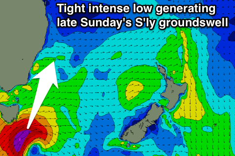
The groundswell component will be generated by a very intense low pushing under Tasmania and into our swell window tomorrow. We'll see a tight fetch of weakening severe-gale to storm-force S/SW winds generated in our southern swell window, producing a moderate to large sized S'ly groundswell.
The timing of this swell looks to be very late in the day Sunday, probably not getting above the size of the mid-period swell with a peak overnight and drop in size Monday.
As touched on above, winds will be poor Sunday with a moderate to fresh S/SW tending S/SE breeze due across the region.
 Monday morning will reveal the most size from the mid-period energy owing to the slow moving nature of the cold-outbreak through the Tasman Sea on Sunday.
South facing beaches on the northern NSW coast should see 4-5ft sets early, easing slowly through the day, further down into Tuesday. Northern ends of the Gold Coast may see 2ft to occasionally 3ft sets, 1ft to maybe 2ft on the Sunny Coast.
Conditions might be a little wobbly and morning sick with only variable breezes due Monday morning (possibly even lingering onshore on the Gold Coast) ahead of fresh afternoon N/NE winds.
Tuesday looks fun at south magnets with a moderate to fresh N/NW'ly ahead of an approaching change early Wednesday.
This change will bring with it a weak increase in S/SE windswell, but more on this Monday. Have a great weekend!
Comments
Arrrhhhh!!!!!!! Flat spell blues...
Plenty of size at D'Bah.. shame about everywhere else in SE Qld!
Still strong out of the south in Coffs Harbour.
You'd all wanna make the most of it.... Cos here comes the flat..........
Spring has sprung!!! Boing!!!!
Although at least EC's showing something reasonably optimistic from the south for early-mid next week.