Patchy surf for the coming days; good trade swell next week and long period E'ly swell afterwards

South-east Queensland and Northern NSW Surf Forecast by Ben Matson (issued Wednesday 15th February)
Best Days: Thurs: small peaky beachies with early light winds. Mon/Tues/Wed: building trade swell though initially wind affected with fresh S/SE winds (OK for outer SE Qld points). Best on Wed, easing slowly Thurs. Next Fri/Sat/Sun: long period E'ly groundswell in SE Qld and Far Northern NSW.
Recap: A southerly groundswell built across Northern NSW on Tuesday, reaching 3-5ft at exposed south facing beaches south of Byron, though local winds weren’t terribly favourable. Surf size remained small across the SE Qld region, being a mix of refracted S’ly swell and short range SE swell. Surf size eased a little into today though there are still good 3ft+ sets at south facing beaches south of Byron, and winds have been a little more convenient. The SE Qld region has remained small with mainly short period SE swells on offer.
This week (Feb 14th - 17th)
Winds will veer easterly then north-easterly over the coming days, limiting wave quality across open beaches. We’ll see more wind strength across the Mid North Coast than anywhere else, but even SE Qld won’t be immune from the devil breeze, even if it only ends up reaching moderate strength through the afternoons.
Thursday morning will offer the best window of opportunity with early light NW winds in most regions ahead of a freshening N’ly tending NE flow. As for surf, today’s S’ly groundswell will ease further and the only steady source of swell is a weak ridge through the central and northern Tasman Sea, which will supply peaky waves across open beaches.
The ridge is actually quite long - stretching from New Zealand’s North Island all the way up into the lower Coral Sea - however wind strengths are only 15-20kts so I doubt we’ll see much more than 2ft+ across open beaches in Northern NSW and smaller surf across SE Qld.
Also in the water from late Thursday (Mid North Coast) through Friday (remaining Northern NSW Coast) is a small S’ly swell, originating from a polar fetch related to the same system responsible for the Tues/Wed south swell.
Our model isn’t picking this swell up very well and I’m not especially confident in the likely size range, however we should see occasional 2ft+ sets at south facing beaches south of Byron, but almost nothing north of the border due to the swell source and direction. With freshening N/NE winds across the Northern NSW coast you’ll have to tuck inside a sheltered northern corner.
This weekend (Feb 18th - 19th)
The weekend looks pretty ordinary with mainly small swells and freshening northerly winds, strongest on Sunday.
The small ridge through the Central/Northern Tasman Sea will have weakened considerably by Friday, so this swell source will ease into Saturday.
Friday’s small south swell will also be on the way out during this period.
Otherwise, a small new trade swell will build throughout Saturday and Sunday though the models have wound back the responsible fetch since Monday’s guidance (around New Caledonia) so we’re not looking at a lot of size across the region.
On the whole, exposed beaches may see occasional 1-2ft sets but I’m not very confident for any major size or quality.
Got the fishing rods at the ready?
Next week (Feb 20th onwards)
A broad, multi-centered tropical low stretching from the northern Coral Sea through the South-western Pacific Ocean will remain slow moving for much of the forecast period.
Initially, a series of small E’ly fetches about its southern flank (south east of New Caledonia, and Fiji) will gradually coalesce into a broader trade flow over the weekend - becoming quite large in its coverage but without any major strength.
This should lead to an increase in E’ly swell across all coasts early next week - probably from Monday afternoon onwards - building towards a peak around Wednesday with sets in the 3ft+ range across SE Qld and Far Northern NSW, slightly smaller across the Mid North Coast.
At the same time, a new coastal ridge will push into the region on Monday, driving gusty S/SE winds across all coasts and building some junky short range windswell at south facing beaches. This will ease through Tuesday afternoon and Wednesday though.
Based on this information, the middle of next week should have some fun waves across most locations (mainly outer points) as the trade swell reaches a peak and the local winds throttle back a touch.
Elsewhere, two regions of potential were identified for significant surf in Monday’s notes, for next week.
However, the models have swung quite divergent regarding the strength and position of both developing weather systems. The Tasman system still has some promise though will probably favour Southern NSW early next week. So I’ll leave that for the time being.
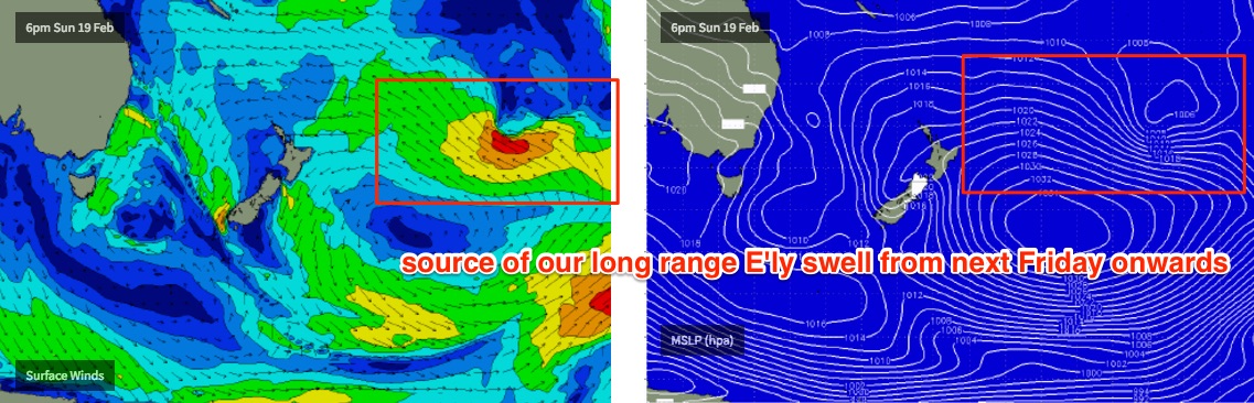
As for our tropical swell window, we’re still looking at a very large high pressure system east of New Zealand interacting with a broad area of tropical activity near the Fijian region. However it now looks like the convergent point between the two systems will occur further east and south than Monday’s model guidance placed it, which is inside the New Zealand swell shadow for Southern NSW and also some parts of Northern NSW (i.e. Mid North Coast).
At this stage I’m also concerned about the large travel distance to reach the SE Qld region. This will certainly erode some size however it’s such an impressive groundswell that we certainly can’t discount there being some good waves - the models have actually strengthened the fetch and also instigated a westward flow towards the end of the run that would likely supercharge the pre-existing swell.
The leading edge of this long range E'ly groundswell is expected spometime later Thursday or Friday next week, peaking over the weekend. Size? Very hard to have confidence in but let's ballpark inconsistent 4ft sets for now across SE Qld.
And if you’re inclined for a strike mission, the East Coast of New Zealand’s North Island is in for one heck of an excellent groundswell during the middle to latter part of next week, and possibly the following weekend.
Anyway, all of this is still quite some time away so let’s see how Friday’s model runs are looking.
Comments
Heading up to the Noosa festival of surfing SUP weekend March 4 & 5 , might just jag the goods!
Thanks for the warning
can we shift that Nth Is. NZ about 500km further south?
Mon arvo was pumpin here on the Mid Nth coast! Wed saw a small south swell in the morn but quality was suss! Bring on the large east swell event!!
Is that event still on course?