Small east swell; then southerly energy for Northern NSW this weekend

South East Queensland and Northern New South Wales Forecast by Ben Matson (issued Wednesday 25th March)
Best Days: Thurs/Fri: small E'ly swell, but SE Qld may suffer under N'ly winds on Thursday (should see NW early in some locations). Light offshore winds should occur south of Byron tho'. S'ly winds developing on Friday with protected beaches best. Sun: fun south swell in Northern NSW with early light winds.
Recap: Small average waves on Tuesday, however we saw a building E’ly swell today that appears to be the much-earlier-than-expected arrival of east swell from TC Rueben. Buoy data confirms this with E’ly swell showing 12.5 seconds at most location (Brisbane spiking to 14 seconds later this afternoon). Northerly winds ruined the surf at many locations but some areas did see brief period of NW winds.
This week (Mar 26 - 27)
This small, inconsistent E’ly swell from TC Rueben will dominate the next few days. Given that we’ve seen the leading edge arrive much earlier than expected, it’s plausible to expect that we may see this event plateau and trend downwards a half day earlier (or more) too.
You will have to aim for the early session on Thursday for the best waves though. Freshening northerly winds are expected in SE Qld during the day, but we should see a period of NW winds in the morning. South of about Byron, light W/NW winds are expected for much of the day (with the northerly trend kicking in later) so there should be good waves across the beach breaks. Surf size should hold around 2-3ft+ at exposed stretches but there will be long breaks between the bigger sets.
On Friday a slow easing trend is expected from this E’ly swell. However we’re looking at a marked change in conditions, thanks to a gusty S/SE change advancing along the coast - current ETA is somewhere around Yamba or Ballina at dawn, reaching the border mid-late morning and then the Sunny Coast early afternoon. Ahead of the change (i.e. in SE Qld), winds should be moderate NW.
Exposed south facing beaches in Northern NSW will probably pick up a low quality windswell in the wake of the change, but those beaches seeing any size will be very bumpy. So, your choices will be split between early beaches (in SE Qld and Far Northern NSW), or semi-exposed points thereafter. Keep your expectations low.
This weekend (Mar 28 - 29)
Our easterly swell from TC Rueben is expected to ease considerably by the weekend, and is not viewed as major source of swell for this period.
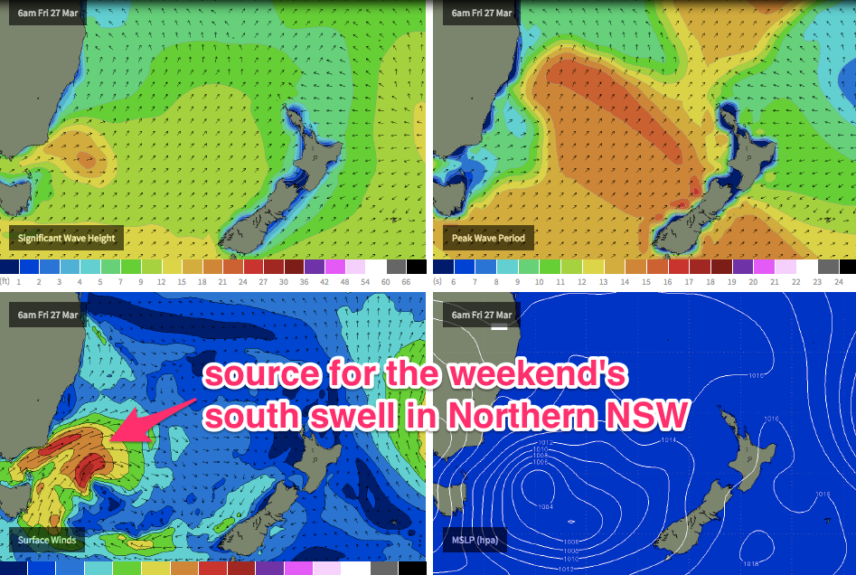
Fortunately (at least for surfers with access the Northern NSW), following Monday’s slight downgrade for the weekend’s south swell, the good news is that we’ve had a slight upgrade over the last few model runs.
The low pushing east of Tasmania on Friday looks like it’ll develop reasonably well inside Northern NSW’s south swell window. Two separate pulses of south swell are expected, one on Saturday morning (Mid North Coast) and afternoon (Far North Coast), with a second swell pushing through overnight Saturday that should still be in the water for the early session on Sunday.
We’ll also have some small short range SE swell in the mix - mainly SE Qld on Saturday - from a ridge building in the wake of Friday’s change. Don’t expect much size, strength or quality from this though, perhaps 1-2ft at most beaches with choppy 2-3ft sets at south facing beaches. It'll ease back in size on Sunday too.
Back to Northern NSW though: Saturday will probably start off small ahead of the new south swell, but once it kicks in we should see 3-4ft sets at south facing beaches. Winds look a little dicey on Saturday, maybe a brief period of early SW winds in some locations but otherwise moderate sou’westers that will cause some problems. So don't get too excited at this stage (I'll update on Friday).
Sunday looks like the pick of the weekend south of the border with early light winds and afternoon sea breezes. The south swell will be easing by this time but there should be good 3ft+ waves at south facing beaches early morning, ahead of an easing trend after lunch. Expect smaller surf at locations not open to the south, and everywhere north of about Byron Bay.
Next week (Mar 30 onwards)
Still nothing of interest beyond the weekend.
A steady procession of very strong fronts through the Southern Ocean will provide intermittent long period south swell (only small in size at the NSW south swell magnets due to the poorly aligned storm track), otherwise we’re mainly focusing our attention towards a slow intensification of the trades through the southern Coral Sea, which should provide a building easterly swell for SE Qld from about Tuesday onwards. More on this in Friday’s update.
Comments
Earlier arrival times means longer period hence more energy hence usually bigger (than forecast) swell heights. Given that the earlier fetch was aimed at regions further to our north the SC wave buoy is showing some more swell than goldy/tweed which would support this.
But what the frck is the go with the Byron buoy. Surely it's wrong with that low period SW wind swell?
Yeah that's a weird one Don, would only get that with a strong S'ly change.
Yeah that's exactly what I thought too Craig.
Ben, surely you're not serious about the Gold Coast reporters pics this morning!!!
Fecking joke!!!
What's the problem Don?
Pictures aren't worth a piece of wet shit mate!!!
Deep breath Don.. not worth getting worked up about. I'll have a chat to the reporter.
Going for the dazed and moody feel.
I like 'em!
Like craig and don, I was slightly surprised with the arrival time yesterday.... I'd expect another pulse today, but it's a shame about the wind......
I'm on the mid north coast , swell arrived yesterday morning and by 7.30am was a solid 3-4ft at the protected point I'm at. Tried to rockfish the front ledge and got say on my arse by much more solid swell there. Just surfed open backbeach with chunky 4ft+ sets. Still well overhead on the point.
Swell must be south of east then Steve as I'm not seeing 4ft+ sets on the wave buoys north of the border at the moment.
Brisbane buoy seems to picking up a bit of swell, Don....
Yep, agreed, but doesn't explain why the Goldy buoy is soooo small if the swell is from the east.
Yeah it's an odd one.......
And how's this also, Crowdy is picking up a strong SE swell, signal and our Coffs Cam (Gallows - south facing) shows strong 3-4ft (maybe a touch bigger)?sets in line with this.
But there's been nothing to generate an significant SE groundswell, and it should be coming in more from the E the further south down the coast you go.
Real weird one..
Craig, maybe swell from that little low which yesterday was around 160/40s
I thought possibly that as well, although it didn't have any major strength and moved fairly quickly to the east. ASCAT not too impressive.
You gents beat me to it.
I'm thinking with SD. Radial spreading and/or slightly better aligned fetch from this girl:
http://manati.star.nesdis.noaa.gov/ascat_images/cur_25km_META/zooms/WMBa...
http://manati.star.nesdis.noaa.gov/ascat_images/cur_25km_META/zooms/WMBa...
That would explain the reason it's missed Sydney and the swell periods on the Crowdy buoy would align with some low in the Tasman creating a fleeting pulse.
ASCAT B picked it up better IMO
http://manati.star.nesdis.noaa.gov/ascat_images/cur_25km_METB/zooms/WMBa...
WINDSAT shows it also
http://manati.star.nesdis.noaa.gov/windsat_images/wdsp_cur/zooms_noaa/WM...
BTW, craig, what is the difference between ascat metop A and metop B??? Are they 2 different satellites?...
Two seperate satellites, but I think they're not too far apart.
"The simultaneous operation of Metop-A and Metop-B will lead to an increased (short term) spatial coverage for the ASCAT-A and ASCAT-B constellation when compared to the coverage of ASCAT-A alone. The exact coverage depends amongst others on the phasing that is chosen for Metop-B with respect to Metop-A. The chosen phasing is a 48.93 minute delay which may be compared to the 101.36 minute orbit duration. Both satellites are in the same 9:30 LST morning orbit (Local Time of Descending Node) and thus almost half an orbit (173.790 ) apart. The Metop satellites have a repeat cycle of 412 orbits or 29 days. The phasing of Metop-B with respect to Metop-A can be simulated by using Metop-A data from a specific moment within the repeat cycle. In order to simulate the 48.93 minute phasing a 12 day (or equally a 17 day) shift in the repeat cycle has to be chosen (see Verspeek and Stoffelen, 2009). "
GFS model had a brief intensification of the SW flank fetch between 10am and 4pm yesterday.
Well then you might find this "b" image of interest...
http://manati.star.nesdis.noaa.gov/ascat_images/day_25km_METB/zooms/WMBd...
Yeah, looks to the source, also hitting Newy real nice!
Cheers on the "A" "B" thing btw.....
Bugger. I mentioned that low in the Sydney notes, but effectively wrote it off (which seems to have been correct, as it's only been 2ft across most Sydney beaches today). But that brief intensification was obviously just enough (I thought it was too short lived) and aimed right inside the perfect swell window for Northern NSW to dleiver this afternoon's pulse. Argh!
Not so sure that is the culprit. Swell is very east here and would have to be to get into the point I'm At. Swell still solid now and from the E.
Around coffs its solid on the sets but more se than east imo,bigger than the forcast.I wonder if the next low will do the same ,similar pattern tomorrow.
Ben, You very rarely let anything get through to the keeper.. So don't give ya'self an uppercut mate lol .... I don't think anyone saw that... And good luck to the boys who lucked a few this arvo down coffs way.. Must've been sweet....
Fr, yeah, different swell..... Rueben up your way...
Who knows.. maybe you're getting a swell combo by the look of the byron buoy....
Gallows was unreal this evening. 4 -5 ft with maybe a touch of S in the swell, but not too much. It wasn't rebounding and wedging the way S swells do.
Epic sesh anyway. Super light crowd, great vibe. Currently in surf coma.
Hope you guys got some where ever you are.
is the board coming out for easter?
proble a bit early