Lots of swell to end the week, best Friday

South Australian Forecast by Craig Brokensha (issued Wednesday 13th September)
Best Days: Keen surfers protected spots South Coast tomorrow morning, Friday South Coast, Sunday South Coast, Tuesday South Coast
Recap
Tiny waves to start the day on the Mid yesterday to 1ft, but the incoming tide and peak in new W/SW swell saw sets to 1-2ft across the coast. Today a semi-stormy 2-3ft of swell has come in across the region, with more size due into the afternoon.
The South Coast saw good sized sets with clean conditions through the morning, though there was a fair wait for the sets. This morning the swell was a touch smaller and conditions workable early, but an onshore change has since moved through.
This week and weekend (Sep 14 - 17)
These notes will be brief as Ben’s away today.
Today's increase in swell across the Mid Coast and change down South is due to a strong mid-latitude front pushing across us from the Bight.
We should see the Mid Coast reaching a more consistent 3ft this afternoon as the mid-period W/SW swell peaks, while the South Coast should see Middleton building to a messy 3-5ft.
Some stronger and better W/SW groundswell from the initial stages of the storm should fill in overnight and peak tomorrow morning mixed in with solid levels of mid-period SW swell.
 We should see the Mid Coast continuing around 3ft through the morning, easing into the afternoon while Middleton looks to come in around 4-5ft+, also easing through the day, back further Friday from 3-4ft.
Winds are expected to remain less than ideal tomorrow and fresh and gusty from the W/SW, but the Victor region should see a period of early W'ly winds.
Friday looks to be the day to surf with W/NW winds due to persist all day.
Moving into the weekend, and the benign mid-latitude front that was expected to strengthen late in our southern swell window is now looking to be a touch weaker.
We'll see a relatively weak fetch of SW winds aimed through our southern swell window on Friday, producing some building S/SW windswell through Saturday across the South Coast, easing Sunday.
Some better but inconsistent SW groundswell is due overnight Saturday, peaking Sunday morning, produced by a distant but slow moving polar low through the southern Indian Ocean.
This swell will be very inconsistent but we should see good 3ft+ waves across Middleton Sunday morning, easing into the afternoon and small Monday. Our models are incorrectly combining the windswell and groundswell from Saturday evening into Sunday morning and over-forecasting the size.
The Mid Coast isn't due to any size off this swell.
Winds will be poor Saturday and fresh from the S'th, tending SE into the afternoon, while Sunday looks excellent with fresh NE tending N/NE winds.
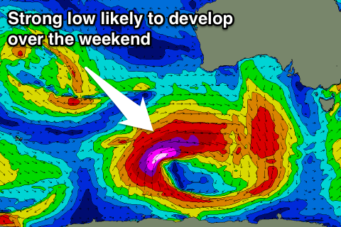
Moving into next week a vigorous polar low is forecast to develop south-west of WA over the weekend, projecting a slow moving fetch of severe-gale to storm-force W/SW winds through our south-western swell window.
A large powerful long-period SW groundswell is expected to fill in Tuesday under W'ly winds, but more on this Friday.
Comments
Reckon pondie would have a wave? Checking the model I figure about 3ft or so
Sorry which day? Guessing Saturday? Yeah should be waves but it's not the best direction.
Thanks dude! Sometimes I think things but don't say them, good guess though, Saturday haha