Indonesia/Maldives forecast October 3rd

Indian Ocean Basin analysis by Craig Brokensha (issued Tuesday 3rd October)
This week through next week (Oct 4 - 13)
Friday's strong S/SW groundswell pulsed well through the afternoon with large surf impacting Indonesia before easing off slowly into the weekend.
Some reinforcing mid-period swell has maintained fun surf into yesterday afternoon and this morning but we've got a much more significant swell on the way for the middle to end of the week.

The strong, slow moving frontal progression we've been discussing the last few updates has moved in and across Western Australia, bringing stormy XL surf to exposed coasts yesterday afternoon and this morning.
For Indonesia we'll see much higher quality, long-period groundswell energy spreading up and into us for Thursday, with an initial increase due through Wednesday afternoon.
A peak is due Thursday morning ahead of a slow easing trend Friday and Saturday.
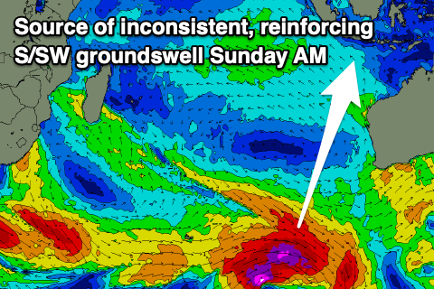
One final pulse of good, long-period S/SW groundswell is due on Sunday morning, generated by a 'bombing' low firing up to the south-southwest of Western Australia, late in eastern Indonesia's swell window yesterday.
The low is generating a fetch of severe-gales and should produce a moderate-large, reinforcing S/SW groundswell for Sunday morning, easing steadily through the day ahead of a much slower week of waves.
To the west the coming S/SW groundswell this week will be a little smaller but peak Thursday morning, while the S'ly groundswell for the weekend looks to be smaller in size.
Over across the Maldives and a spike in SE trade-swell over the weekend is now backing off, though a reinforcing pulse of swell is due over the coming days, maintain plenty of size.
Following this, weak trades throughout the Indian Ocean expected to maintain small to moderate waves through the end of the week and next week.
The S'ly groundswell from the frontal progression pushing up towards Western Australia is due to fill in Wednesday, peaking through the afternoon and then easing Thursday.
Smaller, inconsistent background levels of S'ly swell look to persist through the weekend and next week thanks to persistent relatively weak frontal activity moving through our swell window, south and south-east of South Africa.
We may see a larger swell generator developing south-east of Madagascar early next week but we'll review this Thursday.
Eastern Indonesia:
Large S/SW groundswell building tomorrow afternoon, reaching 8ft by dark and peaking Thursday morning to 10ft across exposed breaks, easing into the afternoon and further Friday.
Moderate-large, reinforcing inconsistent S'ly groundswell for Sunday morning to 6ft+, easing through the day.
Slower outlook next week.
Weak E/SE-SE trades, light and variable each morning. Slightly fresher winds Sunday afternoon and evening.
Uluwatu 16-day Forecast Graph/WAMs
Western Indonesia/Mentawais/South Sumatra:
Large S/SW groundswell building late Wednesday, peaking Thursday to 8ft across exposed breaks, easing Friday.
Small to moderate, reinforcing S'ly groundswell for Sunday to 4ft, easing into Monday.
Fresh to strong SE-S/SE trades across southern locations, fresh to the north over the coming days, easing slightly into Thursday and Friday.
Winds slowly strengthening over the weekend again and persisting next week though becoming more variable to the north.
Mentawai 16-day Forecast Graph/WAMs
Maldives:
Moderate sized SE trade-swell to 4-5ft across the southern atolls tomorrow and Thursday, easing slowly from Friday though not getting below 3-4ft.
Moderate sized S'ly groundswell building Wednesday to 4ft+ across the southern atolls (smaller Male).
Easing swell into Thursday with background levels of energy holding 3ft through the period.
SW-S/SW across central and northern locations, moderate to fresh S/SE-SE across southern locations.
Winds shifting more W/SW into the end of the week across central and northern locations, more variable to the south.
Variable winds into the weekend and next week, tending E/SE across southern locations.
Comments
Latest update is live. Steve's over there, hopefully getting some warm-up sessions in.
7'6 Desert Storm Action @ 8-10 ft + G.Land coming up
The Freeride Voice on Fire.....Yew
pressures on
Hope your not Seedy this morning Freeride gonna be some Action when the Tide turns...
Nice ..Going by sets at Ulu atm should be Double that Size there today.
And Fraser G pitted .
Larry is my surfing inspiration!
75 and still going hard