Indonesia/Maldives forecast September 28th

Indian Ocean Basin analysis by Craig Brokensha (issued Thursday 28th September)
This week through next week (Sep 29 – Oct 6)
The surf is easing across Indonesia, but we've got a good new pulse of energy due tomorrow, with it coming in really well across Western Australia yesterday.
The size now looks to be in the large size range, with a peak due into the afternoon/evening, easing through Saturday and Sunday.
The source was a great fetch of gale to severe-gale winds north and north-east of the Heard Island region, with weaker frontal activity trailing it.
This weaker activity will generate a moderate sized, reinforcing mid-period S/SW swell for Monday afternoon and Tuesday.
Of greater significance is the strong, slow moving frontal progression that's forecast to move up towards Western Australia through the weekend.
A small initial fetch of gales will broaden in scope and reach severe-gale at times while projecting slowly through Indonesia's swell window.
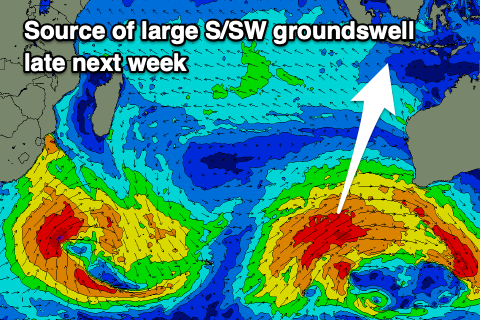
A large, consistent, long-period S/SW groundswell is due from this source with it still on track to kick strongly late Wednesday though peaking Thursday.
The swell should then ease through Friday and the weekend, slowed by a reinforcing pulse of more S'ly groundswell Sunday.
The source of the reinforcing swell will be a strong but late forming polar low in our swell window, to the south-west of Western Australia early-mid next week.
The size looks to be more moderate-large in scope but we'll review this Tuesday.
Weak E/SE-SE trades look to persist for the most part but there is the chance for a more S'ly shift at the peak of the swell next week. EC doesn't have winds going any more south of S/SE though.
Across to the Maldives and small levels of SE trade-swell and background S'ly groundswell are padding out exposed breaks.
We should see both muscle up into next week, with the trade-swell building on the weekend thanks to a strengthening of SE trades over the coming days. It looks to be moderate in size, peaking Sunday followed by reinforcing pulses next week.
The large groundswell impacting Indonesia is due to arrive through Wednesday across the Maldives though only moderate in size, peaking into the afternoon while the secondary reinforcing pulse will be generated too far east and out of our swell window.
Eastern Indonesia:
Large sized S/SW groundswell for Friday, peaking into the afternoon to 6-8ft across exposed breaks, easing through Saturday and further Sunday.
Moderate, mid-period background S/SW swells for early next week to 4-6ft mostly later Monday and Tuesday morning, easing into Wednesday.
Large, consistent, long-period S/SW groundswell building late Wednesday, peaking Thursday to 8-10ft range across exposed breaks.
Weak E/SE-SE trades, light and variable each morning. Similar strength trades shifting a little more S/SE mid-late next week.
Uluwatu 16-day Forecast Graph/WAMs
Western Indonesia/Mentawais/South Sumatra:
Moderate sized + S/SW groundswell building Friday and peaking into the afternoon to 6ft across exposed breaks, easing Saturday.
Reinforcing mid-period S/SW swell for Sunday/Monday to 4-5ft+.
Large S/SW groundswell building late Wednesday, peaking Thursday to 8ft across exposed breaks, easing Friday.
Fresh to strong SE-S/SE trades across southern locations, fresh to the north.
Mentawai 16-day Forecast Graph/WAMs
Maldives:
Smaller levels of SE trade-swell to 3ft. Slightly smaller Male.
Inconsistent S'ly groundswell for the coming days to 3ft+ across the southern atolls, smaller Male.
Moderate sized + SE trade-swell building Saturday afternoon, peaking Sunday/Monday to 4-5ft+ across the southern atolls, slightly smaller Male.
Moderate sized S'ly groundswell for Wednesday to 4ft across the southern atolls (smaller Male).
Slowly strengthening W/SW-SW winds across northern to central atolls, gusty S/SE-SE to the south.
Winds weakening across northern and central locations next week but remaining fresh W/SW, S/SE-SE to the south.
Comments
Notes are live.
Your forecasts are gold and much appreciated, so much more accurate than surfline imo !
Cheers SD!
"Large, consistent, long-period S/SW groundswell building late Wednesday, peaking Thursday to 8-10ft range across exposed breaks."
Gulp.
Haha, yep. Solid! Looks like magnets now could be 10ft+.
Geezus!!!
At least G-Land isn't a magnet... oh, wait...
Yeah, that Java trench is horrible at focussing swells.
F.......K!
https://www.aliexpress.com/item/1005005781698658.html?src=google&src=goo...
https://www.aliexpress.com/item/1005006057290755.html?spm=a2g0o.productl...
Damn Brewer is too Long For Virgin Flight.
^^^
737 - up to 3 mts...Will Fit.
Solid on the Bukit atm.