Fun S'ly swell pulses followed by a larger N/NE swell event

Eastern Tasmania Surf Forecast by Craig Brokensha (issued Wednesday 10th October)
Best Days: Thursday morning, Friday south magnets, Saturday south magnets, northern corners Monday through Wednesday, open beaches Thursday
Recap
Fun small levels of E/NE swell yesterday, with a junky new S/SE windswell today with average conditions.
Today’s Forecaster Notes are brought to you by Rip Curl
This week and next week (Oct 11 – 19)
The strong cold front pushing up past us last night, responsible for today's S/SE windswell is currently clearing to the west and with this we'll see a drop in size through tomorrow and further Friday.
Northern ends and south magnets look to ease from 3ft+ with a morning W'ly offshore, tending S/SE later morning.
Friday morning looks smaller and weak with 2ft to maybe 3ft sets at south magnets, but a stronger S'ly groundswell is due to build later in the day, peaking overnight and easing Saturday.
 This will be generated today and early tomorrow by a strong polar fetch of W/SW tending SW gales projecting towards New Zealand through our southern swell window.
We should see 3ft+ of groundswell later Friday across south swell magnets with a morning W/NW offshore, giving into E/NE tending NE sea breezes.
NW tending N/NE winds are then expected on Saturday as the swell eases 3ft to possibly 4ft.
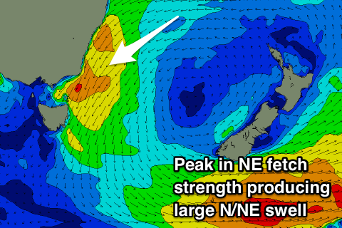
This S'ly groundswell will continue to fade through Sunday, replaced by building levels of N/NE windswell that is expected to reach the moderate to large size range early-mid next week.
This swell event will develop as a strong and stubborn high in the Tasman Sea is squeezed by a deepening inland surface trough and then mid-latitude low forming in the Bight, stalling into early next week west of Victoria.
A broadening and strengthening fetch of N/NE winds will be aimed through our north-eastern swell window resulting in building levels of N/NE windswell tending mid-period swell from Sunday through Thursday next week, largest Tuesday when winds are strongest Monday evening.
Size wise we're looking at surf reaching the 6ft range at this stage with winds from the N/NE initially, tending more N/NW through Tuesday and more so Wednesday ahead of a W'ly change Thursday as the low moves east.
The timing of this change and the peak of the swell are moving around a bit still so check back Friday for more of an idea on this swell event.