Dynamic outlook from the weekend

Eastern Tasmania Surf Forecast by Craig Brokensha (issued Monday 22nd January)
Best Days: The weekend onwards
Recap
Easing surf from 2-3ft though with less than ideal winds on Saturday, best in protected spots, cleaner and back to 1-2ft yesterday.
This morning we've got tiny clean waves leftover on the coast.
Today’s Forecaster Notes are brought to you by Rip Curl
This week and weekend (Jan 23 - 28)
We're not likely too see much NE windswell tomorrow, with a weak fetch off the southern NSW coast not expected to generate much above 1ft.
There's then nothing major due until later in the week onwards, and this is where things get interesting.
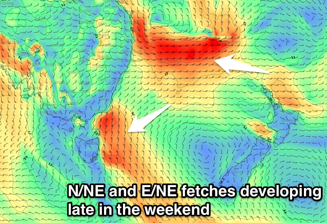 Firstly we'll see a strong high in the Tasman Sea stall as a surface trough across Victoria and deepening tropical low to the highs north squeeze it on two flanks.
The trough will see a building N/NE windswell through the weekend, growing strongest Sunday/Monday.
We'll then see the trough moving east, cutting off the infeed of NE winds but the fetch on the northern flank of the high will dip down more towards us as the tropical low drifts south.
This will generate some good E/NE swell once the NE windswell eases, arriving mid-week.
Size wise we're probably looking at surf between 3-5ft out of the NE and E/NE, but we'll have a closer look at this Wednesday as the models are still coming to terms with the coming setup.