Small SE swell tomorrow morning, S'ly swell for the weekend

Eastern Tasmania Surf Forecast by Craig Brokensha (issued Wednesday 13th September)
Best Days: Thursday morning, Sunday and Monday morning south magnets
Recap
Some tiny clean E/SE swell yesterday, while today similar amounts of S'ly swell have been seen across the coast.
This week and weekend (Sep 14 - 17)
We should hopefully see a slightly stronger SE signal in the water tomorrow, generated by a broad and good fetch of SE gales south of New Zealand earlier this week.
Open beaches should hopefully see 2ft sets in the morning, fading through the day. Conditions are looking clean all day with a fresh W'ly tending W/SW breeze.
Into Friday the coast is expected to become tiny, but into the weekend we should see some new south swell out on the coast.
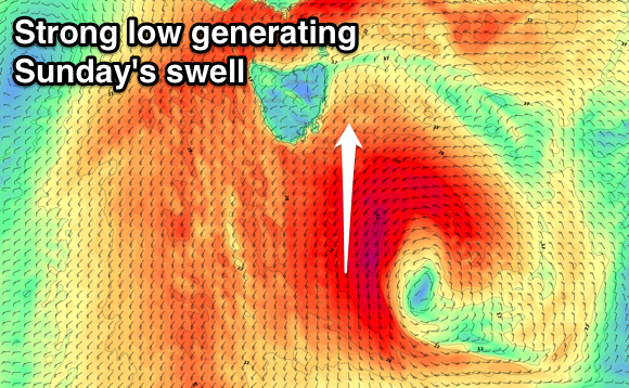 The dynamics of a deepening low moving across us have changed a little, with the low now forecast to form south of the state and more in the South Arm's swell window rather than ours.
Through Friday afternoon and evening we'll see a very tight and intense low pressure system generating a fetch of severe-gale to storm-force W/SW winds through our southern swell window, followed by a better aligned fetch of S/SW gales on the tail of the low through Saturday.
Some very acute S'ly groundswell is due off the initial fetch for Saturday, coming in at 2ft across south magnets but with W/SW tending S'ly winds.
Sunday should see a better S'ly swell filling in coming in around 3-4ft across south magnets with W'ly tending NW winds. The swell will fade through the day, smaller into Monday with some weak N/NE windswell on the cards for Tuesday. More on this Friday though.