Weak high pressure is moving in over the continent with a highly mobile passage across the Tasman from tomorrow. Rapid movement of fronts re-occurs over the weekend with a stronger S swell signal now expected into next week.
Primary tabs
/reports/forecaster-notes/eastern-tasmania/2025/09/17/small-blend-ne-windswells-and-s-pulses-under
freeride76
Wednesday, 17 September 2025
/reports/forecaster-notes/eastern-tasmania/2025/09/15/gusty-w-nw-winds-ahead-alternating-small-ne-and
freeride76
Monday, 15 September 2025
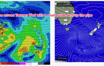
High pressure is in the Tasman in typical spring position- with a N’ly-NW’ly flow being enhanced as a mid-latitude low approaches from well south of the Bight. An inland trough and a front associated with the low move across the SE of the country and into the Tasman later Tues, with following fronts and a trough into the Tasman Wed.
/reports/forecaster-notes/eastern-tasmania/2025/09/12/s-swells-easing-over-the-weekend-small-swells
freeride76
Friday, 12 September 2025
High pressure moves into the Tasman Sun and winds get a more NW tilt as a front approaches from the W.
/reports/forecaster-notes/eastern-tasmania/2025/09/10/more-s-pulses-ahead
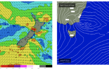
freeride76
Wednesday, 10 September 2025
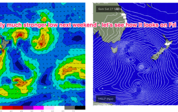
Into the weekend and we’ll see fast moving lows racing under Tasmania Thurs and Fri/Sat.

/reports/forecaster-notes/eastern-tasmania/2025/09/08/south-south-south
Craig
Monday, 8 September 2025
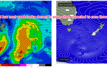
We've got multiple pulse of southerly swell on the cards from Wednesday through the weekend and beyond.

/reports/forecaster-notes/eastern-tasmania/2025/09/05/small-blend-s-and-ne-windswell-continues
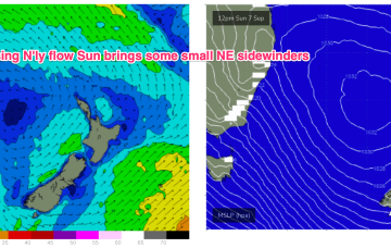
freeride76
Friday, 5 September 2025
High pressure sits in the NE Tasman for a couple of days early next week- holding a N’ly wind flow through Mon and Tues with minor NE windswell offers some rideable surf.
/reports/forecaster-notes/eastern-tasmania/2025/09/03/small-swells-around-the-compass-in-the-short
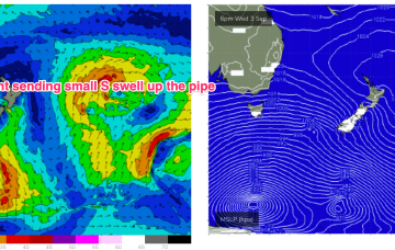
freeride76
Wednesday, 3 September 2025
The front passing Thurs is followed by a trough and more well angled SW-S fetch which will see some short range S swell build to 2-3ft during the day.
/reports/forecaster-notes/eastern-tasmania/2025/09/01/small-s-pulses-week-fresh-wlies
freeride76
Monday, 1 September 2025
Still on track for S pulses this week for the first week of spring.
/reports/forecaster-notes/eastern-tasmania/2025/08/29/sly-swell-spike-sat-more-small-s-pulses-next
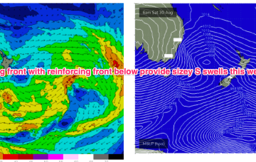
freeride76
Friday, 29 August 2025
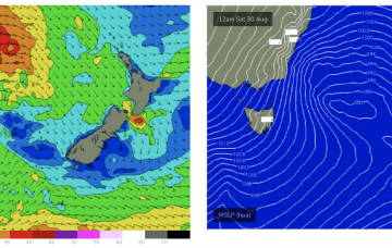
Still on track for a wintry blast this weekend as a strong cold front tied to an intense low currently west of Tasmania sweeps up over the SE overnight and enters the Tasman early tomorrow morning.
/reports/forecaster-notes/eastern-tasmania/2025/08/27/s-swell-spike-ahead-wintry-blast-over-the
freeride76
Wednesday, 27 August 2025
A powerful front and low forming near Tasmania drives gales up from the Bight over the inland of the SE of the continent, then re-enters the Tasman as SW gales to severe gales early Sat morning.