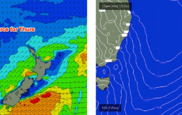
The key to scoring good surf will be to identify the timing of the wind change, as we should see westerlies somewhere in the middle.
Primary tabs
/reports/forecaster-notes/sydney-hunter-illawarra/2023/12/15/coupla-windows-opportunity-target
thermalben
Friday, 15 December 2023
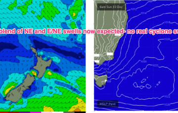
/reports/forecaster-notes/sydney-hunter-illawarra/2023/12/13/scrappy-surf-ahead-brief-windows
thermalben
Wednesday, 13 December 2023
Easing southerly swells will dominate tomorrow, and we’ll also see a small level of local NE windswell thanks to this afternoon’s developing breeze.
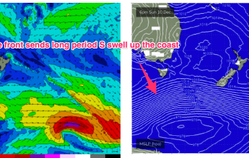
/reports/forecaster-notes/sydney-hunter-illawarra/2023/12/11/nice-round-long-period-south-swell-ahead
thermalben
Monday, 11 December 2023
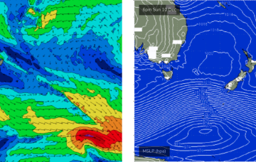
From about lunchtime onwards (South Coast) and late afternoon across the Sydney region, we'll be on high alert for the leading edge of a decent long period southerly groundswell.
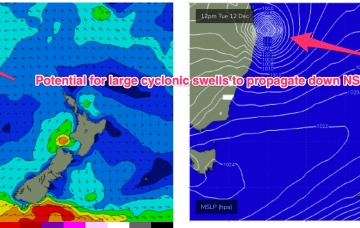
/reports/forecaster-notes/sydney-hunter-illawarra/2023/12/07/back-small-mixed-bag-some-sly
freeride76
Friday, 8 December 2023
TC Jasper is set to take a W’ly track with a Far North QLD coastal crossing now the most likely outcome and thus no real surf potential for temperate NSW.
/reports/forecaster-notes/sydney-hunter-illawarra/2023/12/06/big-downgrade-tc-jasper-heads-qld
freeride76
Wednesday, 6 December 2023
TC Jasper has formed in water surrounding the Solomon Islands and is intensifying under favourable conditions. Most models now are suggesting a SW-W curvature as it enters the Coral Sea, with a limited surf potential compared to Mondays notes, especially for temperate NSW.
/reports/forecaster-notes/sydney-hunter-illawarra/2023/12/04/doldrums-pattern-week-all-eyes-tc-next
freeride76
Monday, 4 December 2023
Weak high pressure in the Tasman and a trough is creating a “doldrums” type pattern of slack pressure gradients and small swells this week, with a few wind changes to negotiate. No major swells expected this week. The headline feature is a potential major tropical cyclone drifting into the Coral Sea with a poleward (southwards) track late this week, over the weekend and into next week.
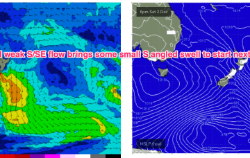
/reports/forecaster-notes/sydney-hunter-illawarra/2023/11/30/fun-easing-surf-over-the-weekend-plenty
freeride76
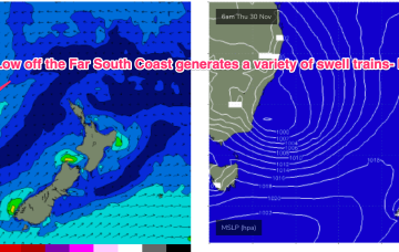
Friday, 1 December 2023
Low pressure has moved off the coast and is slow moving, with a broad fetch of strong E’ly winds on the southern flank of the low supplying plenty of E-E/SE swell to Southern NSW (and Tasmania).
/reports/forecaster-notes/sydney-hunter-illawarra/2023/11/29/troughy-dynamic-pattern-keeps-active
freeride76
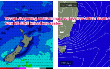
Wednesday, 29 November 2023
A dynamic weather event is underway as a complex inland low approaches the Far South Coast of NSW, expected to enter the Tasman Sea tomorrow. A moist NE-E/NE infeed into the low is generating plenty of rain (heaviest falls on the South Coast) and building swells from the same direction.
/reports/forecaster-notes/sydney-hunter-illawarra/2023/11/26/tricky-dynamic-week-approaching-trough
freeride76
Monday, 27 November 2023
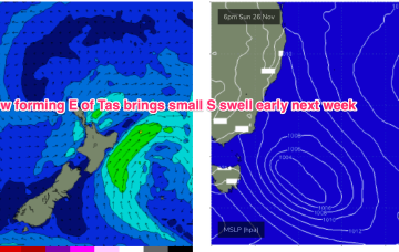
Another dynamic week ahead with a complex trough expected to form a surface low off the NSW South Coast mid week, details below.
/reports/forecaster-notes/sydney-hunter-illawarra/2023/11/23/lots-little-swell-sources-popping-in-the
freeride76
Friday, 24 November 2023
Not a great deal of action likely this weekend. High pressure is straddling Tasmania with the remnants of a front lingering near New Zealand with an off-axis fetch. A coastal trough and an inland trough maintain unstable conditions with a developing N-NE flow over the weekend.