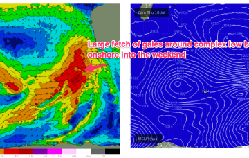
A week of solid, blustery surf ahead (after the weekend)
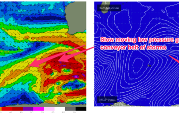
I remain unconvinced as to the weekend’s surf potential, relative to the vigorous storm track pushing through the Bight.
A slow moving complex low gyre is well to the south of WA with constant conveyor belt fetches reinforcing already active sea states and generating large swells for WA. A northwards sitting high is producing W’ly onshore ridging with the massive gyre. Pretty standard active winter pattern.
ECMWF has a slightly stronger tradewind style fetch extending southwards from the tropics into the Central Coral Sea by mid next week.
A slightly stronger NE windswell looks on track for Fri into Sat as pre-frontal winds freshen.
A trough of low pressure and front rapidly push into the Tasman during Sat with the low deepening rapidly. Gales will be short-lived as the system is whisked away to the NE but sufficient to whip up a spike in S swell Sun.
Much stronger S swell signal for Sunday. A trough of low pressure and front rapidly push into the Tasman. Gales will be short-lived but sufficient to whip up a spike in S swell.
We still have an unusual S/SE groundswell inbound for Thursday, generated by an earlier incarnation of this system when it was at more polar latitudes.
The models have strengthened things in the last few runs so there’s been a subsequent upgrade in surf and wind for the forecast period.
The storm track for the end of this week and weekend looks very impressive on the synoptic charts, but once you analyse the surface wind field, it starts to fall apart at the seams, just a little bit.
A long fetch of SW gales is aimed up and moving towards WA as part of a complex gyre well south off the state. Rotating fetches around the edge of the gyre will hold large pulses of SW swell right through the end of the week into and over the weekend