Quite a few tiny days ahead
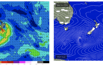
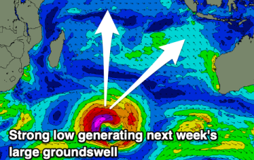
Weak high pressure in the Tasman is holding a very weak fetch of SE winds in the Coral Sea which is adding minor amounts of energy to a tradeswell on it’s last legs.
There’s really nothing of interest at all next week with surf remaining tiny right into next weekend.
A passage of weak but favourable frontal system should generate small, fun surf from Sunday.
Today's swell will ease over the coming days ahead of a large, powerful groundswell early next week.
Longer term and we’ll be watching the South Pacific Convergence Zone for signs of low pressure development near Fiji later next week, possibly even retrograding back towards the Australian continent.
The coming period looks less favourable with the Mid Coast swells peaking with onshore winds, mostly onshore down South.
The beaches are the pick today ahead of a favourable run for the Surf Coast.
We’re still looking at a peak in S swell Mon but the frontal passage responsible for it now looks more mobile and poorly aligned so wave heights get a haircut.
Strengthening westerly winds across Indonesia with slower swells in the Maldives. The incoming swell for Indonesia looks to be under-forecast on the charts.
Once the new high sets up shop in the Tasman we’ll see a weak E’ly flow set up in the Coral Sea which will generate a tiny, just rideable surf into the weekend.