Fun blend of swells ahead with a dynamic outlook for Xmas week
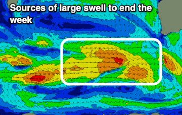
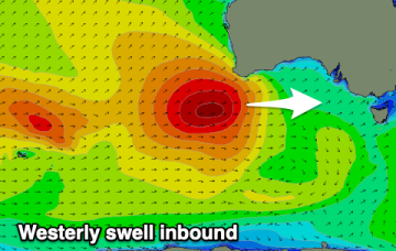
A small spike in short range S swell will be reinforced by better quality SE-E/SE swells later this week.
Conditions won't be as favourable but more large surf is due to end off the week.
We currently have a deepening trough of low pressure developing behind a front which is bringing fresh and gusty S’ly winds up the NSW coastline, extending into the sub-tropics through the day. This trough of low pressure deepens into a surface low in the Tasman and is expected to track in a northerly direction through the short term.
Today is one of the days of the year across the Mid Coast.
This trough of low pressure deepens into a surface low in the Tasman and is expected to track in a northerly direction through the short term. The initial spike in short range S swell will be reinforced by better quality S/SE swells late this week into the weekend.
Hit the beaches over the coming days ahead of tricky, mostly onshore winds from the weekend into early-mid next week.
An infeed into the low is better aimed at SEQLD so we are only seeing tiny surf in CQ. That tiny signal then eases right back through this week to surf less than 1ft.
Try the East Coast for a surf.
We’ll see some swell from this pattern, first from the initial short range S swell and then some better quality S/SE swell as the surface low retrogrades from near the South Island back into the Tasman.