Hang in there just a little longer
Monday, 24 October 2022
Hang in there just a little longer
Monday, 24 October 2022
Friday looks terrible, albeit interesting. Saturday morning has some potential.
Friday looks terrible, albeit interesting. Saturday morning has some potential.
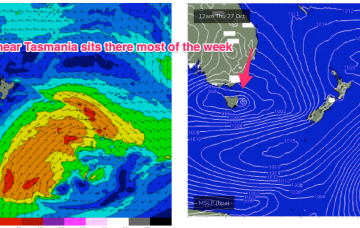
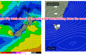
A sub-tropical low which threatened SEQLD and NENSW over the weekend after it formed off the Capricorn coast is now steaming southwards at a fair clip, sliding along a high pressure ridge from a large (1035 hPa) high under Tasmania and dragging a strong fetch with it. The low is expected to merge with an inland low and horseshoe trough on the Gippsland Coast tomorrow forming a stalled low pressure gyre near Tasmania.
A sub-tropical low which threatened SEQLD and NENSW over the weekend after it formed off the Capricorn coast is now steaming southwards at a fair clip, sliding along a high pressure ridge from a large (1035 hPa) high under Tasmania. The low is expected to merge with an inland low and horseshoe trough on the Gippsland Coast tomorrow forming a stalled low pressure gyre near Tasmania.
A stationary synoptic pattern for most of next week means generally poor surf across both coasts.
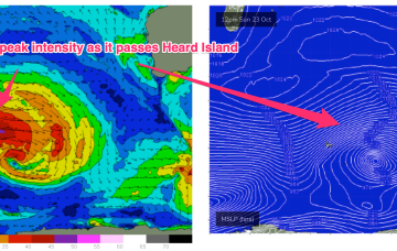
Late Wed will see the next increase in swell and the system responsible, a polar low which intensifies as it passes Heard Island Sun, now looks stronger and less zonal, with a swathe of 30ft seas sending groundswell to WA.
It's a tricky weekend of waves ahead. But there are items worth monitoring.
Dynamic weekend f/cast ahead as a strong NE fetch builds a chunky windswell and a trough then brings an extended period of elevated wave heights from the SE to E.
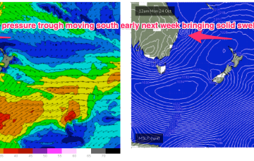
Very dynamic weekend forecast ahead as a low pressure trough forms off the CQ coast today and forms a small surface low which drifts south to hug the coast over the weekend, accelerating away to the south through early next week.
A trough of low pressure off the QLD Coast forms a small surface low over the weekend and this moves south Mon, interacting with a strong high moving south of Tasmania and another interior low forming in a trough line late in the weekend. This potent brew intensifies the NE-E/NE fetch forming in the Coral Sea and drags it south, where it more directly impacts temperate NSW.
We’ve got a couple of small swells inbound over the next few days, but Sunday has the most potential.