Good swell for the weekend with an improvement in winds
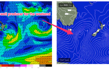
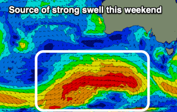
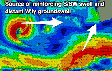
The wind forecast for tomorrow has improved slightly for the South Coast along with a good, new swell.
Eyes back to the E next week. The high in the Tasman and a blocking band of high pressure well to the south of the continent effectively annuls the southern swell window. With that shut down we’ll be looking to the East.
An upgrade is now expected for Sat as the low east of Tasmania deepened and produced a longer and stronger fetch of SSW winds extending north and south of Tasmanian latitudes.
There's no change to the weekend outlook, while next week and beyond looks very sub-par.
Lack of swell generating tradewinds in the Coral Sea sees tiny/flat surf extend through this weekend.
In the short run and the outlook is dynamic. The low sitting off the East coats maintains an E/NE-E infeed so E swell will hold in the 3ft range.
We're looking at a poor end to the week with better options developing into the weekend.
Still a complex, troughy pattern in play with a slow moving trough of low pressure drifting south off the Gippsland coast towards waters East of Tasmania. A front sweeping in behind the trough is bringing a clearing W’ly flow through temperate NSW today, reaching the sub-tropics tomorrow.
Conditions are clean with an inconsistent new W/SW groundswell, while some stronger swell with favourable winds is due later week.
There'll be plenty of swell for the South Coast from later Friday but winds look dicey initially before slowly improving.