Strong swell for the weekend, average next week

Victorian Surf Forecast by Craig Brokensha (issued Friday 31st March)
Best Days: Early afternoon today Surf Coast ahead of the change, keen and experienced surfers tomorrow, keen surfers Sunday morning, beaches Monday morning, desperate surfers Tuesday morning, exposed beaches Thursday morning
Features of the Forecast (tl;dr)
- Moderate sized + SW groundswell arriving later Fri with freshening S/SW winds, peaking Sat with gusty but slowly abating S/SW tending S winds
- Slowly easing mid-period SW swell Sun with light-moderate S/SE-SE winds, freshening later
- Easing surf Mon with early E/SE tending E/NE winds ahead of S/SE sea breezes
- Smaller Tue with variable offshore tending SE winds
- Smaller Wed with mod-fresh SE winds
- Small, inconsistent mid-period S/SW swell Thu, easing Fri
- Fresh N/NE winds Thu, gusty N/NW Fri
Recap
A weak kick in SW swell following Wednesday's change coming in at 2-3ft on the Surf Coast magnets and 4ft to the east. Winds and conditions were workable for the keen in selected spots to the west, poor to the east.
We've hit a low point in activity this morning but a new pulse of moderate sized + SW groundswell should arrive into the afternoon, with it starting to build on the Cape Sorell wave buoy. Winds will start shifting SW by early-mid afternoon and then become strong from the S/SW into the late afternoon as the swell really starts to build.
This weekend and next week (Apr 1 - 7)
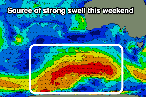
The weekend ahead will see a moderate sized + SW groundswell peaking through tomorrow, easing slowly through Sunday and early next week. This prolonged run of swell has been generated by a strong polar frontal progression that formed to the south-southwest of Western Australia on Tuesday, with a fetch of gale to severe-gale W/SW winds projected east, then weakening as a secondary front pushed up on its tail.
This front has since weakened to our south-west, with trailing weak frontal activity due to produce some small reinforcing mid-period swell for Monday/Tuesday.
Looking at the groundswell and with it building this afternoon and evening, a peak is due tomorrow across the Surf Coast with 4-5ft waves expected across most exposed breaks, with the magnets likely to see the rare bigger cleanup. To the east we should see 6ft+ surf with the rare 8ft cleanup.
Conditions will remain poor following this afternoon's change as a high pushes in from west, bringing gusty S/SW winds that are due to slowly ease in strength through the afternoon.
Into Sunday winds will be weaker but lingering out of the S/SE-SE creating bumpy conditions as the swell starts to ease back from 3-5ft on the Surf Coast magnets, 6ft to the east.
Early next week is still looking best for the beaches to the east with the slowly easing swell and winds from the eastern quadrant.
Monday will improve through the morning as winds shift from the E/SE to E/NE and weaken along with easing 4ft sets on the exposed beaches, smaller and 3ft on the Surf Coast magnets (mostly 2-3ft).
Into Tuesday the Surf Coast should see variable tending offshore winds, with light NE winds to the east but the swell will be smaller and fading from 2ft+ on the Surf Coast magnets, 3ft to the east.
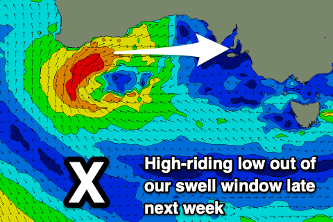
Now, the models are coming into alignment regarding the outlook for the end of the week and beyond and unfortunately it's not great. A deepening mid-latitude low in the Bight will prevent any major swell generating systems from forming in the Southern Ocean, while sitting too far north to generate any meaningful westerly swell for us next weekend.
It'll bring strengthening N/NE winds on Thursday, shifting N/NW on Friday but with only small levels of background mid-period S/SW swell to 2ft max on the Surf Coast Thursday and 2-3ft to the east.
The low is then due to progress slowly east and move into the Tasman Sea, bringing strong SE winds and a run of poor SE windswell. More on this into next week. Have a great weekend!
Comments
Geez. A true reflection of last 3 years down here , aside from a little fix here and there. Sad send off for Owen.
Heard a rumour at the Kennett River Pub that Kelly has been working with an Indonesian witch doctor to curse all wassle events now it’s clear he can no longer win the thing. Seems a bit rough for the good burghers of surfcoast shire wanting a little wiggle over the Easter break.
Could the Bells Easter classic be transitioning to a beach break near you?
I don’t think they do that anymore? You’d think Johanna would be pretty decent at times over the period
Looking at Metuv ( Victoria University, Wellington NZ) weather maps for victoria for the next week or so, which is usually very accurate modelling, it doesn't look good.
I reckon there’ll be some super fun waves on the beaches Sunday avo, Monday and Tuesday.
Wind prognosis not too bad if you don’t mind slight onshore glass.