Great tomorrow, deteriorating from Sunday

Western Australian Forecast by Craig Brokensha (issued Friday June 27th)
Best Days: Today, tomorrow, early Sunday, Tuesday morning selected locations Perth/Mandurah, next Friday Perth/Mandurah
Features of the Forecast (tl;dr)
- Easing W/SW groundswell tomorrow while tweaking more SW in direction
- Large reinforcing S/SW groundswell for the South West into the PM, easing Sun
- Mod-fresh E/NE winds tomorrow
- Strengthening E/NE tending NE winds Sun
- Moderate + sized, inconsistent W/SW groundswell Mon, easing slowly Tue
- Strong N/NE tending N/NW winds Mon
- Mix of mid-period W/SW swell Tue and new mod-large SW groundswell for the PM, easing Wed
- Mod-fresh W/NW winds Tue, NE in the AM to the north
- Strengthening W/NW winds with a building mid-period swell Wed, stronger SW and larger Thu
- Easing swell Fri with S'ly winds in the South West, E/NE to the north
Recap
The good groundswell from Wednesday continued to ease into yesterday with less favourable northerly winds kicking across most locations apart from a window of cleaner conditions in Perth through the morning.
Today, we’ve got our large W/SW groundswell filling in with the swell coming in strong and to 10ft+ across the South West, 3-4ft in Mandurah while Perth started small and to 2ft but has since kicked more to 3ft on the sets.
Conditions are best across the metro locations with variable offshore winds, lumpy in the South West with funky, variable winds and a bit of lump/crumble (conditions have since improved).
Winds are due to remain variable all day across the South West from the north-eastern quadrant, possibly swinging more E’ly later. Perth and Mandurah will remain clean all day.

Strong, clean sets this morning
This week and next (Jun 28 - Jul 4)
Today’s peak in W/SW groundswell will ease over the weekend but this trend only looks to be slow owing to the slow moving nature of the east-southeast tracking low linked to it.
This low moved through our south-western swell window while at strength, resulting in tomorrow morning still being large from the SW, while into the afternoon a new pulse of large S/SW groundswell is due across the South West. This was generated by an intensification of severe-gale to sub-gale-force W/SW winds through our southern swell yesterday.
Size wise, the South West should still be 8-10ft, with the reinforcing pulse slowing this trend into the afternoon, easing more noticeably from 6ft Sunday morning.
Mandurah should still be 3ft tomorrow morning, with 2ft to possibly 3ft sets in Perth, easing and smaller Sunday.
Conditions should be great tomorrow with a moderate to fresh E/NE offshore expected to last all day, stronger E/NE tending NE through Sunday.
Monday looks average with stronger N/NE tending N-N/NW winds, spoiling a new, moderate + sized pulse of W/SW groundswell.
This swell was generated by a strong but weakening frontal progression moving out from under South Africa earlier this week, with fetches of W/SW gales, breaking down once north of about the Heard Island region.
The South West should see inconsistent 6ft+ waves with 2-3ft sets in Mandurah and 2ft+ waves across Perth but with those poor northerly winds.
A reinforcing pulse of groundswell looks to offer a touch less size through Tuesday, mixed in with some small mid-period W’ly swell generated by a weak mid-latitude low moving in over the weekend, bringing the strengthening winds Monday.
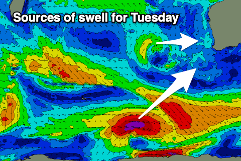
This should maintain 2ft+ waves across Perth and 2-3ft sets in Mandurah with early NE winds, onshore in the South West with W/NW winds.
Into the afternoon a new pulse of inconsistent SW groundswell is due in the South West, generated by a tight, polar fetch of severe-gale W’ly winds moving along the polar shelf, from the Heard Island region this evening and tomorrow.
A kick to 6-8ft is due in the South West, easing Wednesday along with strengthening W/NW winds. Perth and Mandurah will be smaller Wednesday and with possible early N/NE winds.
Into Wednesday a strengthening polar front pushing up and into us will bring with it stronger W/NW winds, shifting W/SW-SW through Thursday and bringing with it some moderate to large sized, mid-period SW swell.
No major quality is due, with Friday seeing easing levels of weak swell, cleaner across Perth/Mandurah but with S’ly winds persisting in the South West.
Longer term, a much more significant cold outbreak may be seen into early next week bringing larger, stormy surf but more on this Monday. Have a great weekend!