Plenty of great waves this week, next week looking even better

Western Australian Forecast by Ben Matson (issued Monday May 12th)
Features of the Forecast (tl;dr)
- Smaller but cleaner on Tuesday
- New groundswell building late Wed, peaking late Thurs, easing Fri, solid and clean in Margs, small and clean on the metro beaches
- Easing surf with N'ly winds for the weekend
- Large surf pulsing next Tues/Wed/Thurs with generally good winds
- Chance for a windy XL event the following weekend
Recap
Metro beaches were tiny early Saturday, and a late new swell was accompanied by fresh cross shore winds. Sunday saw small clean leftovers on the metro beaches that eased throughout the day and we’ve seen another small swell provide fun waves today. Margaret River saw early light S’ly winds become fresh by mid-morning Saturday, with a late building swell showing best Sunday with clean 4ft sets under early offshore winds. A new swell for today has arrived a little earlier than expected (peaking around lunchtime instead of late afternoon), and it’s also pushed right at the top of the expected size range with some solid 6ft sets across the reefs (see below). Fresh onshore winds kicked in around noon, creating bumpy conditions this afternoon.
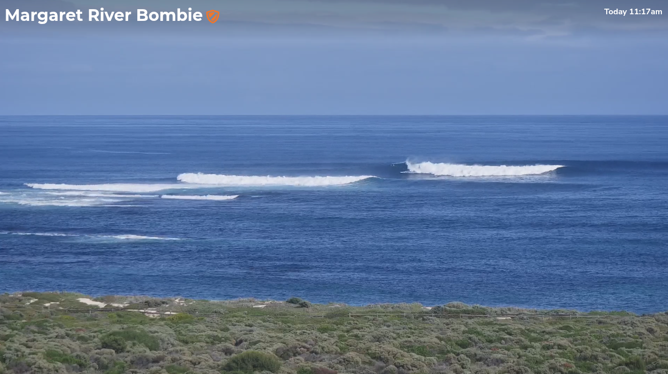
Perfect glassy walls on offer just before lunchtime today
This week (May 13 - 16)
Tuesday will see easing size from today but better conditions with winds around to the SE. Overnight southerlies will create some surface bump across exposed Margs regions but it should clean up. Expect inconsistent 3-5ft sets slowly easing through the day.
Metro beaches will be small but clean with SE winds and slow 1-2ft sets tops. There won't be a lot in it.
The rest of the week look nice and clean with weak high pressure leading to generally light variable winds and sea breezes.
Wednesday morning will start off small, but a new swell is expected to push through during the day, generated by a broad but poorly aligned storm track that developed south of Africa last week and has been slowly tracking eastwards through the southern Indian Ocean.
Because the primary fetch was aimed away fom our region (towards Antarctica), we’ll see less consistent sideband energy push into the coast - however the broad, sustained nature of this fetch should override some of the directional deficiencies, and with a peak in size due late Thursday, maybe early Friday (ahead of a slow easing into the weekend) we’re looking at a couple of days of very nice surf.
Late Wednesday should see 4-6ft sets across exposed reefs in the lower south-west, with late Thursday looking more towards a steady 6ft with occasional 6-8ft bombs at the swell magnets. Friday will ease from a similar size early morning, back to a less consistent 4-6ft through the day.
Metro beaches are looking at a similar trend but with much size, reaching 2ft in Perth and maybe 2-3ft throughout Mandurah at the height of the swell (smaller either side).
This weekend (May 17 - 18)
Slowly easing size is expected all weekend, and winds will be around to the north as a high develops in the Bight and a series of powerful fronts strengthen in the southern Indian Ocean.
Metro beaches will be very small and slow, and not really worthwhile. Early Saturday is your best chance for an occasional 1ft+ wave.
Across the Margs region, Saturday should still offer some early 3-5ft sets (smaller later) and the morning's winds should be NE ahead of a gradual swing to the north. Expect smaller sets on Sunday in the 2-3ft+ range with a similar wind regime.
Next week (May 19 onwards)
The long term outlook is shaping up to deliver a series of large, back to back groundswells.
Over the coming days a powerful storm pattern is expected to track below Africa. Although a long way from the mainland, this will set into motion a conveyor belt of polar lows and fronts that will slingshot around an amplifying Long Wave Trough to the west of Heard Island.
Ideally, we like the storm track to be close to the coast so that there’s the least amount of size loss as possible, but in this case the long duration of the storm track means that the extra distance isn’t as much of an issue. What it will ensure is a round of quality, overlapping groundswells that’re expected to nose into the coast from late Monday onwards, pulsing in size through Tuesday, Wednesday and Thursday.
It’s too early to pin down specific daily swell trends for this period but at its height we could be looking at solid 8-10ft sets across the swell magnets, maybe more. Winds should be favourable for at least one or two days of this period as well. I'll be able to find tune the specifics as the week progresses.
Some model guidance is also suggesting a powerful cut-off low may develop behind this frontal progression, clipping the WA coast sometime around next Friday or Saturday and generating a windy XL swell for the region. However this is a very long time away and will require close monitoring.
Either way, the surf outlook for next week is shaping up to deliver quite a few days of large waves to the region, which is great timing for the WSL event.