One more large swell to come

Western Australian forecast by Craig Brokensha (issued Wednesday February 5th)
Best Days: This morning, protected spots tomorrow afternoon, Friday morning, Saturday morning in the South West
Features of the Forecast (tl;dr)
- Temp low point in swell tomorrow AM ahead of a large SW-S/SW groundswell into the PM, peaking late, easing Fri
- Strong S/SE winds tomorrow, mod-fresh E/SE Fri AM ahead of sea breezes
- Smaller Sat with E-E/NE winds ahead of sea breezes
- Strengthening W/NW winds Sun with a small-mod sized, building mid-period swell
- Easing surf Mon with S/SE winds
- Mod sized SW swell for mid-week with S/SW winds
Recap
Yesterday started windy and clean across all locations with building levels of mid-period swell and less consistent groundswell. The South West was 6ft or so before building more towards 8ft+ into the afternoon but not before sea breezes kicked in.
Mandurah kicked to a good 3ft with offshore winds holding until early afternoon with Perth building to 2ft.
This morning the swell is on the ease but nice and clean again under gusty offshore winds. The South West is 6-8ft, with 3ft sets persisting across Mandurah, 2ft in Perth.

Strong lines at midday yesterday
This week and next (Feb 6 - 14)
The swell is expected to ease temporarily into tomorrow morning across the state, but our next pulse of large S/SW groundswell is due to arrive through the day, peaking into the late afternoon/evening and then easing Friday.
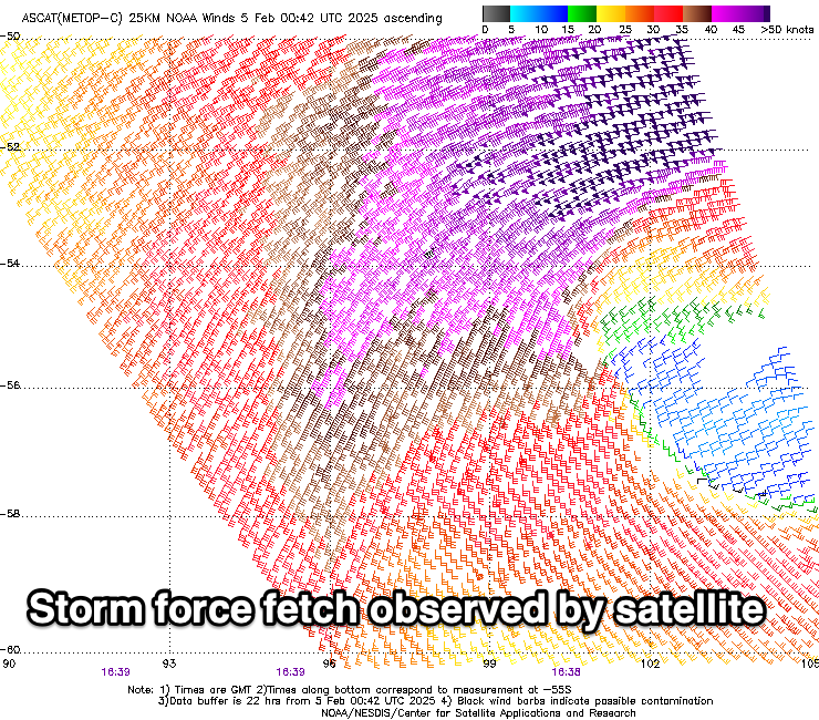
As touched on in Monday’s update, the remnants of Tropical Cyclone Elvis drifted south-east from Madagascar and was absorbed into the westerly storm track, resulting in a great fetch of severe-gale to storm-force winds being projected through our south-western and southern swell windows.
We should see a large spike of swell to 8ft+ later tomorrow, easing from 6-8ft on Friday with Mandurah kicking late to 2-3ft, easing from 2ft+ Friday, 2ft or so in Perth.
Local winds will be generally average tomorrow and strong from the S/SE, favouring protected spots while Friday looks the pick under a moderate to fresh E/SE offshore ahead of strong sea breezes.
Saturday will be nice and clean with lighter offshore winds but smaller and fading, best in the South West.
Now, as also mentioned on Monday, a weak trough moving in from the west on the weekend looks to bring no major swell, and in any case, strengthening W/NW winds will create poor conditions Sunday as it builds, S/SE on Monday along with no real size.
Into next week, a strengthening polar front may generate a mid-period SW swell mid-week under average S/SW winds but we’ll have a closer look at this Friday.
Comments
The Northern Indian Ocean looks like it's about to light up big time. Can imagine all types of normally docile stretches of coast in it's far Northern boundaries all the way across to the Middle East would be turning into all kinds of epic ness.