Active week of swells with workable winds

Western Australian Surf Forecast by Craig Brokensha (issued Monday February 26th)
Best Days: Wednesday morning in the South West. Thursday morning in the South West, Friday, Saturday in the South West, Sunday morning in the South West
Features of the Forecast (tl;dr)
- Moderate sized, mid-period SW swell for tomorrow PM and Wed AM
- Strong S-S/SE winds tomorrow AM, shifting S/SW, E/SE-SE tending strong S/SW Wed
- Moderate sized mid-period SW swell for Thu AM, with a larger groundswell for later in the day and Fri AM, easing
- Mod-fresh SE tending strong S/SW winds Thu, strong SE tending S/SE Fri
- Strong SE tending E/SE winds Sat with easing surf, E/NE tending N/NW Sun
Recap
Poor weather and surf on Saturday with strengthening onshore winds thanks to a trough moving across the region, much better yesterday across metro locations with 1-2ft of leftover swell with clean conditions. The South West offered a touch more size with protected spots fairing best under strong SE winds.
Today looks much better around Margs with clean conditions and fun 4ft surf, tiny to the north.
This week and weekend (Feb 27 – Mar 3)
The coming week looks active and productive for surf with strengthening Southern Ocean storm activity currently taking place to the south-west of the state.
Firstly some fun mid-period SW swell is due into tomorrow afternoon, generated by a broad but relatively weak frontal system that was south-west of us on Friday and Saturday.
A fun kick to 4-5ft+ is due through tomorrow afternoon/evening, easing from a similar size Wednesday morning, only 1-1.5ft to the north.
Conditions still look average tomorrow with strong S tending S/SE winds during the morning, S/SW into the afternoon with Wednesday morning looking much better with an E/SE-SE offshore ahead of strong S/SW sea breezes.
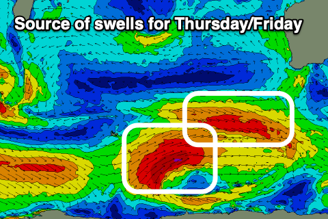
Into Thursday and Friday our stronger pulses of SW swell are due, with a good mid-period increase due Thursday morning ahead of the stronger groundswell later afternoon, holding early Friday morning.
Thursday's swell will be generated by pre-frontal gale-force W/NW winds at the head of a polar low, with post-frontal gale to severe-gale W/SW winds at the tail, generating the larger groundswell.
Thursday should see 5-6ft waves in the South West, 1-2ft to the north in Mandurah and 1-1.5ft across Perth with the groundswell building to the 8ft range through the afternoon, easing Friday from a similar sized with 2-3ft sets in Mandurah and 2ft waves across Perth.
Locally, winds on Thursday morning look SE ahead of sea breezes, similar Friday morning and stronger, favouring protected spots.
The weekend looks cleaner but windy with easing levels of swell (slowed by a reinforcing pulse Saturday afternoon/Sunday morning) and developing, strong E/SE winds Saturday morning, weaker and more E/NE on Sunday morning.
Following this activity it looks like we'll see some downtime ahead of stronger surf later next week. More on this Wednesday though.