Fun weekend, smaller swells next week

Western Australian Surf Forecast by Craig Brokensha (issued Friday December 8th)
Best Days: Tomorrow morning, Sunday and Monday mornings in the South West, Tuesday in the South West ahead of sea breezes
Features of the Forecast (tl;dr)
- Moderate sized +, inconsistent SW groundswell for later today, peaking early tomorrow, easing
- Fresh E/SE-E winds ahead of strong sea breezes tomorrow
- Easing swell Sun with fresh E winds ahead of sea breezes
- Small pulse of SW groundswell for Mon AM with E/NE tending N winds ahead of sea breezes
- Small-moderate sized mid-period W/SW swell building Tue PM, peaking Wed AM, easing
- E/NE winds ahead of late sea breezes Tue, S/SE tending S/SW winds Wed
- Easing swell Thu with strong SE tending S/SE winds
Recap
Easing surf yesterday with workable conditions in the South West through the morning, coming in at 4ft or so, 2ft across Mandurah and 1-2ft in Perth. This morning is smaller and more windswelly across metro locations, doable for the keen while the South West is choppy and average.
This weekend and next week (Dec 9 - 15)
The weekend is looking fun for a surf thanks to the arrival of an inconsistent and good sized SW groundswell, generated to the south-east of South Africa last weekend.
Due to the large travel distance the swell will lose size and consistency, with it due to arrive later today but peak tomorrow morning to 5-6ft in the South West, 2ft in Mandurah and 1-2ft across Perth, easing through the day.
A high moving in under the state should swing winds to the E/SE-E tomorrow morning (fresh and gusty), creating great conditions ahead of strong sea breezes, with fresh E winds on Sunday morning ahead of sea breezes as the swell fades away.
As touched on in Wednesday's update, a quick-fire and short fetch of W/SW gales dipping south-east through our swell window should generate a small spike of glancing SW groundswell Monday which now looks to peak in the morning to 3-4ft or so.
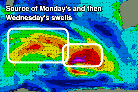
Behind this, a better, broader fetch of strong to near-gale-force W/SW winds will be generated, producing an inconsistent but fun sized mid-period W/SW swell that's due to build slowly Tuesday but peak Wednesday.
A peak to 4-5ft is due in the South West, likely early Wednesday, easing thereafter with inconsistent 1-2ft sets to the north.
Looking at the local winds and favourable E/NE winds are due on Monday morning ahead of later, weaker developing sea breezes.
E/NE winds are due again Tuesday ahead of weak sea breezes, with Wednesday unfortunately seeing a S/SE change as a trough slides east. Stronger SE winds are then due as the swell eases Thursday.
Longer term we may see some healthy storm activity firing up to the south-west of us later next week and weekend, generating S/SW swells (though at this stage not overly sizey), but more on this Monday. Have a great weekend!