Small, hot and windy

Western Australian Surf Forecast by Craig Brokensha (issued Wednesday November 22nd)
Best Days: South West swell magnets for the keen tomorrow and Friday when winds ease, Tuesday morning for the keen across the South West magnets
Features of the Forecast (tl;dr)
- Easing surf into the end of the week, slowed a touch Friday with a small background swell
- Strong E/NE winds, giving into mid-PM sea breezes tomorrow, early-PM Fri
- Fading surf on the weekend with strong E/SE tending S winds Sat, strong E tending S Sun
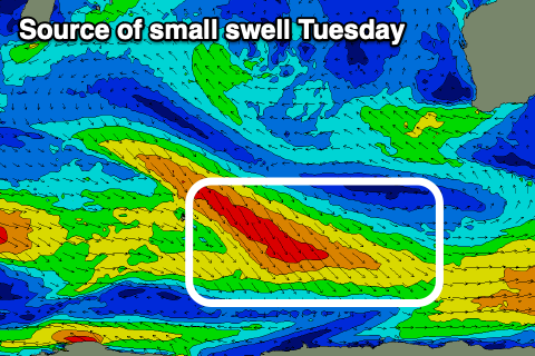
- Small mid-period S/SW swell for Tue with strong E/NE tending S/SE winds
- Small, inconsistent mid-period SW swell building Thu PM, peaking Fri AM with strong S/SE winds
Recap
A small pulse of swell with clean conditions across the South West yesterday, easing a touch today while Perth and Mandurah remained tiny but hot, great for a swim.
This week and weekend (Nov 23 - 26)
The swell seen the last two days will fade into the end of the week, with a small reinforcing pulse of background swell showing Friday not due to top the existing size (3ft sets on the South West magnets).
Strong, hot E/NE winds are due both tomorrow and Friday mornings, tending variable into the early-mid afternoons ahead of sea breezes (early Friday).
Small, fading surf is due on the weekend with strong, morning E/SE winds Saturday ahead of sea breezes, strong E Sunday ahead of mid-late afternoon sea breezes.
Moving into next week, the outlook remains very slow thanks to persistent, blocking high pressure setting up camp south and south-west of us, shutting down our main swell generating region.
Weak fronts skirting around the base of the high look to generate more, small pulses of mid-period S/SW swell. The first is due Tuesday but only to 2-3ft or so, followed by a secondary better pulse of mid-period SW swell Thursday/Friday that looks to be more to 3-4ft or so.
Perth and Mandurah will remain tiny and unsurfable for the most part.
Unfortunately the heat trough and low linked to the current strong morning winds and hot days will shift south-east across us early next week, bringing an onshore change and then strong S/SE winds mid-late week, spoiling the small swells.
The longer term outlook remains slow unfortunately but check back Friday for any improvement.